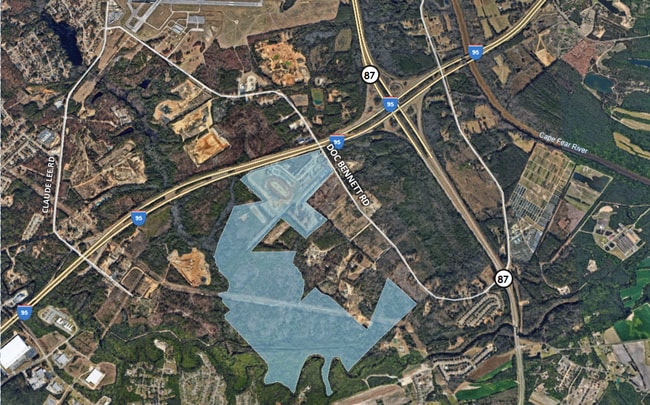
Property Record
3035 Whitman Rd, Fayetteville, NC 28306
NEARBY LISTINGS FOR SALE OR LEASE
Property Detail
3035 Whitman Rd
Fayetteville, NC
Airport Area (Comm)
0434-92-0838
PL:0089-0157
Commercialnec
Cumberland
X
North Carolina
3720044400J
4599
2025
129.82 AC
2025
East Fayetteville
001603
Fayetteville
539 SF
DEMOGRAPHICS near 3035 Whitman Rd
1 Mile
3 Mile
5 Mile
2024 Total Population
171
10,168
43,177
2029 Population
177
10,411
43,992
Pop Growth 2024-2029
+ 3.51%
+ 2.39%
+ 1.89%
Average Age
40
36
37
2024 Total Households
66
3,668
16,195
HH Growth 2024-2029
+ 4.55%
+ 2.54%
+ 2.04%
Median Household Inc
$73,124
$69,940
$61,418
Avg Household Size
2.50
2.70
2.60
2024 Avg HH Vehicles
2.00
2.00
2.00
Median Home Value
$247,058
$256,892
$228,730
Median Year Built
1988
1998
1995
Nearby Places
Map Layers
Map Styles
 Street
 Aerial
- Restaurants
- Banks
- Shops
- Fitness
- Groceries
PUBLIC TRANSPORTATION
COMMUTER RAIL
Fayetteville Amtrak Station (Palmetto - Amtrak, Silver Meteor - Amtrak)
DRIVE
WALK
Distance
Fayetteville Amtrak Station (Palmetto - Amtrak, Silver Meteor - Amtrak)
14 min
7.8 mi
AIRPORT
Fayetteville Regional/Grannis Field
DRIVE
WALK
Distance
Fayetteville Regional/Grannis Field
9 min
3.4 mi
Freight Ports
Port of Wilmington
DRIVE
WALK
Distance
Port of Wilmington
121 min
85.6 mi
Nearby Properties
Address
Land Use
TOTAL SIZE
Lot Size
Zoning
Address
Land Use
TOTAL SIZE
Lot Size
Zoning
4,947 SF
937.13 AC
MA
Address
Land Use
TOTAL SIZE
Lot Size
Zoning
1,117,824 SF
227 AC
MP
Address
Land Use
TOTAL SIZE
Lot Size
Zoning
14,000 SF
97.50 AC
MP
Address
Land Use
TOTAL SIZE
Lot Size
Zoning
500,548 SF
45.12 AC
MP
Address
Land Use
TOTAL SIZE
Lot Size
Zoning
13.78 AC
M1P-LIGHT
Address
Land Use
TOTAL SIZE
Lot Size
Zoning
365,607 SF
59.08 AC
HI
Address
Land Use
TOTAL SIZE
Lot Size
Zoning
259,960 SF
31 AC
MP
Address
Land Use
TOTAL SIZE
Lot Size
Zoning
182,589 SF
39.04 AC
MP
Address
Land Use
TOTAL SIZE
Lot Size
Zoning
21.10 AC
MP
Address
Land Use
TOTAL SIZE
Lot Size
Zoning
88,383 SF
13.30 AC
CC
Address
Land Use
TOTAL SIZE
Lot Size
Zoning
16.41 AC
MP
Address
Land Use
TOTAL SIZE
Lot Size
Zoning
9,404 SF
62.05 AC
RR
Address
Land Use
TOTAL SIZE
Lot Size
Zoning
35,242 SF
56.61 AC
MP
Address
Land Use
TOTAL SIZE
Lot Size
Zoning
58,915 SF
18.75 AC
MP
Address
Land Use
TOTAL SIZE
Lot Size
Zoning
64,445 SF
37.03 AC
MP
Address
Land Use
TOTAL SIZE
Lot Size
Zoning
56,282 SF
9.68 AC
CP
Address
Land Use
TOTAL SIZE
Lot Size
Zoning
115,200 SF
33.80 AC
MP
Address
Land Use
TOTAL SIZE
Lot Size
Zoning
5,544 SF
244.73 AC
MP
Address
Land Use
TOTAL SIZE
Lot Size
Zoning
144,000 SF
21.30 AC
MP
Address
Land Use
TOTAL SIZE
Lot Size
Zoning
1,104 SF
4.33 AC
CP
Address
Land Use
TOTAL SIZE
Lot Size
Zoning
29,240 SF
5.33 AC
MP
Address
Land Use
TOTAL SIZE
Lot Size
Zoning
8,000 SF
5.73 AC
M1P-LIGHT
Address
Land Use
TOTAL SIZE
Lot Size
Zoning
8,778 SF
3.51 AC
CP
Address
Land Use
TOTAL SIZE
Lot Size
Zoning
66,428 SF
8.50 AC
MP
Address
Land Use
TOTAL SIZE
Lot Size
Zoning
37,392 SF
11 AC
C3
Address
Land Use
TOTAL SIZE
Lot Size
Zoning
1,860 SF
25.40 AC
CP
Address
Land Use
TOTAL SIZE
Lot Size
Zoning
2,931 SF
100 AC
R6A
Address
Land Use
TOTAL SIZE
Lot Size
Zoning
8,989 SF
2.46 AC
HI
Address
Land Use
TOTAL SIZE
Lot Size
Zoning
109,250 SF
11 AC
MP
Address
Land Use
TOTAL SIZE
Lot Size
Zoning
18,750 SF
3.94 AC
C2P
The World's #1 Commercial Real Estate Marketplace
Connect with us
© 2026 CoStar Group
The information above has been obtained from sources believed reliable. While we do not doubt its accuracy we have not verified it and make no guarantee, warranty or representation about it. It is your responsibility to independently confirm its accuracy and completeness. Any projections, opinions, assumptions, or estimates used are for example only and do not represent the current or future performance of the property. The value of this transaction to you depends on tax and other factors which should be evaluated by your tax, financial, and legal advisors. You and your advisors should conduct a careful, independent investigation of the property to determine to your satisfaction the suitability of the property for your needs.