Property Record
3037 Mustang Dr, Grapevine, TX 76051
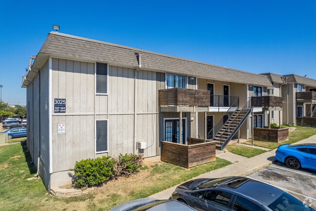


Property Detail
3037 Mustang Dr
Dallas-Fort Worth-Arlington, TX
SHADY OAKS ESTATES ADDITION BLOCK A LOT A2
04540808
TARRANT
Multifamilydwelling
Texas
B and X Area of moderate flood hazard, usually the area between the limits of the 100-year and 500-year floods.
a2
2024
3.79 AC
2025
Grapevine
113635
Dallas/Ft Worth
85,568 SF
NEARBY LISTINGS FOR SALE OR LEASE
-
-
View all Grapevine listings for sale on LoopNet.com
DEMOGRAPHICS near 3037 Mustang Dr
1 mile
3 mile
5 mile
2025 Total Population
10,353
61,486
160,543
2030 Population
10,837
64,354
168,481
Pop Growth 2025-2030
+ 4.67%
+ 4.66%
+ 4.94%
Average Age
37
41
41
2025 Total Households
4,058
22,862
60,817
HH Growth 2025-2030
+ 4.85%
+ 4.87%
+ 4.96%
Median Household Inc
$74,116
$141,557
$128,607
Avg Household Size
2.50
2.60
2.60
2025 Avg HH Vehicles
2.00
2.00
2.00
Median Home Value
$479,946
$680,466
$626,488
Median Year Built
1988
1992
1991
Nearby Places
Map Layers
Map Styles
 Street
 Aerial
Layers
 Traffic
 Biking
Places
Listings with unknown addresses are not visible on the map
- Restaurants
- Banks
- Shops
- Fitness
- Groceries
PUBLIC TRANSPORTATION
COMMUTER RAIL
Drive
Walk
Distance
14 min
9.2 mi
AIRPORT
Dallas-Fort Worth International
Drive
Walk
Distance
Dallas-Fort Worth International
11 min
7.1 mi
Dallas Love Field
Drive
Walk
Distance
Dallas Love Field
29 min
20.8 mi
Nearby Properties
Address
Land Use
TOTAL SIZE
Lot Size
Zoning
Address
Land Use
TOTAL SIZE
Lot Size
Zoning
624,642 SF
15.38 AC
Address
Land Use
TOTAL SIZE
Lot Size
Zoning
332,665 SF
9.83 AC
Address
Land Use
TOTAL SIZE
Lot Size
Zoning
397,272 SF
12.35 AC
Address
Land Use
TOTAL SIZE
Lot Size
Zoning
360,898 SF
5.51 AC
Address
Land Use
TOTAL SIZE
Lot Size
Zoning
464,476 SF
5.08 AC
Address
Land Use
TOTAL SIZE
Lot Size
Zoning
401,397 SF
14.94 AC
Address
Land Use
TOTAL SIZE
Lot Size
Zoning
321,993 SF
18.20 AC
Address
Land Use
TOTAL SIZE
Lot Size
Zoning
203,458 SF
16.58 AC
Address
Land Use
TOTAL SIZE
Lot Size
Zoning
264,000 SF
15.06 AC
Address
Land Use
TOTAL SIZE
Lot Size
Zoning
234,200 SF
274.75 AC
Address
Land Use
TOTAL SIZE
Lot Size
Zoning
235,902 SF
16.20 AC
Address
Land Use
TOTAL SIZE
Lot Size
Zoning
230,666 SF
13.33 AC
Address
Land Use
TOTAL SIZE
Lot Size
Zoning
300,000 SF
27.13 AC
Address
Land Use
TOTAL SIZE
Lot Size
Zoning
242,000 SF
3.72 AC
Address
Land Use
TOTAL SIZE
Lot Size
Zoning
150,510 SF
6.35 AC
Address
Land Use
TOTAL SIZE
Lot Size
Zoning
261,466 SF
6.83 AC
Address
Land Use
TOTAL SIZE
Lot Size
Zoning
214,908 SF
13.55 AC
Address
Land Use
TOTAL SIZE
Lot Size
Zoning
196,350 SF
12.05 AC
Address
Land Use
TOTAL SIZE
Lot Size
Zoning
921,172 SF
105 AC
Address
Land Use
TOTAL SIZE
Lot Size
Zoning
177,093 SF
10.79 AC
Address
Land Use
TOTAL SIZE
Lot Size
Zoning
247,505 SF
32 AC
Address
Land Use
TOTAL SIZE
Lot Size
Zoning
306,052 SF
1.92 AC
Address
Land Use
TOTAL SIZE
Lot Size
Zoning
255,288 SF
10.57 AC
Address
Land Use
TOTAL SIZE
Lot Size
Zoning
99,780 SF
0.38 AC
Address
Land Use
TOTAL SIZE
Lot Size
Zoning
206,950 SF
12.13 AC
Address
Land Use
TOTAL SIZE
Lot Size
Zoning
89,500 SF
8.47 AC
Address
Land Use
TOTAL SIZE
Lot Size
Zoning
266,000 SF
0.56 AC
Address
Land Use
TOTAL SIZE
Lot Size
Zoning
136,358 SF
16.51 AC
Address
Land Use
TOTAL SIZE
Lot Size
Zoning
167,847 SF
8.39 AC
Address
Land Use
TOTAL SIZE
Lot Size
Zoning
100.88 AC
The World's #1 Commercial Real Estate Marketplace
Connect with us
© 2026 CoStar Group
The information above has been obtained from sources believed reliable. While we do not doubt its accuracy we have not verified it and make no guarantee, warranty or representation about it. It is your responsibility to independently confirm its accuracy and completeness. Any projections, opinions, assumptions, or estimates used are for example only and do not represent the current or future performance of the property. The value of this transaction to you depends on tax and other factors which should be evaluated by your tax, financial, and legal advisors. You and your advisors should conduct a careful, independent investigation of the property to determine to your satisfaction the suitability of the property for your needs.