Property Record
3039 Date St, Riverside, CA 92507
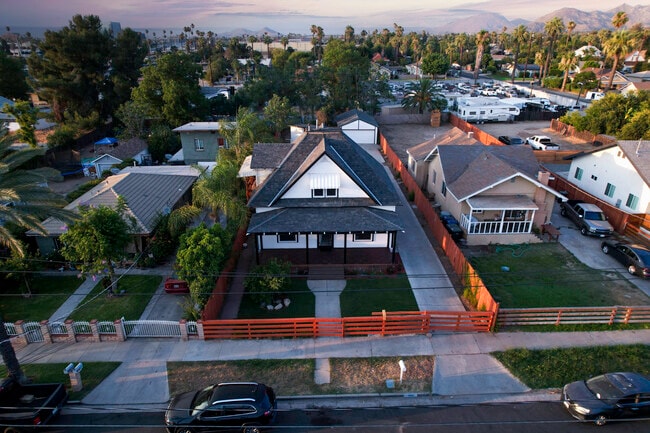

This Property Is For Sale
NEARBY LISTINGS FOR SALE OR LEASE
Property Detail
3039 Date St
Riverside-San Bernardino-Ontario, CA
Halls Add Div B
219-121-010
POR LOT 26 MB 009/002 SB HALLS ADD DIV B
Sfr
Riverside
X
California
06065C0728G
26
2024
0.21 AC
2025
Eastside
030400
Inland Empire (California)
2,103 SF
DEMOGRAPHICS near 3039 Date St
1 mile
3 mile
5 mile
2024 Total Population
15,679
128,679
249,096
2029 Population
16,983
138,748
268,760
Pop Growth 2024-2029
+ 8.32%
+ 7.82%
+ 7.89%
Average Age
36
36
36
2024 Total Households
4,546
40,073
75,519
HH Growth 2024-2029
+ 7.96%
+ 7.65%
+ 7.68%
Median Household Inc
$82,140
$84,116
$90,082
Avg Household Size
3.00
2.90
3.00
2024 Avg HH Vehicles
2.00
2.00
2.00
Median Home Value
$654,290
$627,566
$629,605
Median Year Built
1953
1970
1974
Nearby Places
Map Layers
Map Styles
 Street
 Aerial
Transit
 Traffic
 Biking
Places
Listings with unknown addresses are not visible on the map
- Restaurants
- Banks
- Shops
- Fitness
- Groceries
PUBLIC TRANSPORTATION
COMMUTER RAIL
Riverside-Downtown (91 Line - Southern California Regional Rail Authority (Metrolink), Inland Empire-Orange County Line - Southern California Regional Rail Authority (Metrolink), Riverside Line - Southern California Regional Rail Authority (Metrolink))
Drive
Walk
Distance
Riverside-Downtown (91 Line - Southern California Regional Rail Authority (Metrolink), Inland Empire-Orange County Line - Southern California Regional Rail Authority (Metrolink), Riverside Line - Southern California Regional Rail Authority (Metrolink))
3 min
17 min
0.9 mi
Riverside-Hunter Park/Ucr (Metrolink 91-Perris Valley Line - Metrolink Trains)
Drive
Walk
Distance
Riverside-Hunter Park/Ucr (Metrolink 91-Perris Valley Line - Metrolink Trains)
7 min
4.3 mi
AIRPORT
Ontario International
Drive
Walk
Distance
Ontario International
26 min
18.8 mi
Freight Ports
Port of Long Beach
Drive
Walk
Distance
Port of Long Beach
72 min
56.4 mi
Nearby Properties
Address
Land Use
TOTAL SIZE
Lot Size
Zoning
Address
Land Use
TOTAL SIZE
Lot Size
Zoning
412,950 SF
23.16 AC
C2
Address
Land Use
TOTAL SIZE
Lot Size
Zoning
247,416 SF
10.17 AC
Address
Land Use
TOTAL SIZE
Lot Size
Zoning
350,278 SF
1.21 AC
Address
Land Use
TOTAL SIZE
Lot Size
Zoning
26,879 SF
16.27 AC
R3
Address
Land Use
TOTAL SIZE
Lot Size
Zoning
217,036 SF
1.66 AC
C2
Address
Land Use
TOTAL SIZE
Lot Size
Zoning
169,980 SF
10.51 AC
C3
Address
Land Use
TOTAL SIZE
Lot Size
Zoning
156,241 SF
2.55 AC
Address
Land Use
TOTAL SIZE
Lot Size
Zoning
209,734 SF
10.87 AC
R3
Address
Land Use
TOTAL SIZE
Lot Size
Zoning
139,454 SF
0.97 AC
DSP
Address
Land Use
TOTAL SIZE
Lot Size
Zoning
37,729 SF
3.23 AC
Address
Land Use
TOTAL SIZE
Lot Size
Zoning
36,010 SF
11.76 AC
R3
Address
Land Use
TOTAL SIZE
Lot Size
Zoning
87,600 SF
0.39 AC
Address
Land Use
TOTAL SIZE
Lot Size
Zoning
134,944 SF
2.52 AC
Address
Land Use
TOTAL SIZE
Lot Size
Zoning
415,990 SF
5.16 AC
Address
Land Use
TOTAL SIZE
Lot Size
Zoning
129,739 SF
5.08 AC
Address
Land Use
TOTAL SIZE
Lot Size
Zoning
69,660 SF
0.62 AC
C3
Address
Land Use
TOTAL SIZE
Lot Size
Zoning
108,930 SF
4.89 AC
Address
Land Use
TOTAL SIZE
Lot Size
Zoning
446,832 SF
5.03 AC
Address
Land Use
TOTAL SIZE
Lot Size
Zoning
Address
Land Use
TOTAL SIZE
Lot Size
Zoning
156,998 SF
11.90 AC
MP
Address
Land Use
TOTAL SIZE
Lot Size
Zoning
83,572 SF
2.93 AC
Address
Land Use
TOTAL SIZE
Lot Size
Zoning
8.81 AC
R3S3
Address
Land Use
TOTAL SIZE
Lot Size
Zoning
17,542 SF
8.27 AC
R1
Address
Land Use
TOTAL SIZE
Lot Size
Zoning
156,688 SF
6.09 AC
BMP
Address
Land Use
TOTAL SIZE
Lot Size
Zoning
306,278 SF
2.50 AC
C3
Address
Land Use
TOTAL SIZE
Lot Size
Zoning
85,322 SF
0.48 AC
The World's #1 Commercial Real Estate Marketplace
Connect with us
© 2026 CoStar Group
The information above has been obtained from sources believed reliable. While we do not doubt its accuracy we have not verified it and make no guarantee, warranty or representation about it. It is your responsibility to independently confirm its accuracy and completeness. Any projections, opinions, assumptions, or estimates used are for example only and do not represent the current or future performance of the property. The value of this transaction to you depends on tax and other factors which should be evaluated by your tax, financial, and legal advisors. You and your advisors should conduct a careful, independent investigation of the property to determine to your satisfaction the suitability of the property for your needs.