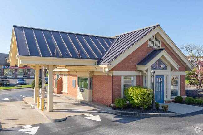
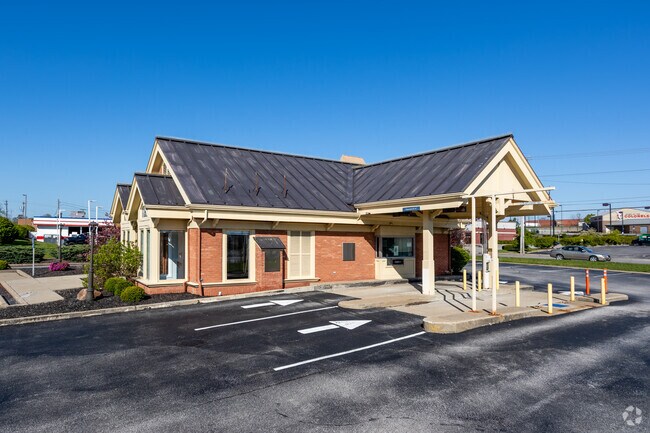
Property Record
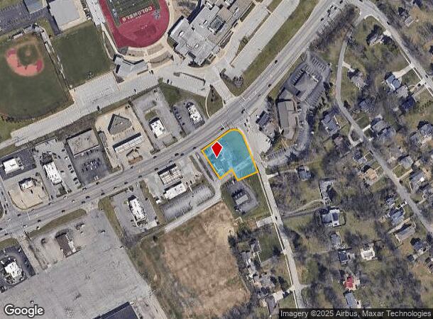
3039 Dixie Hwy, Edgewood, KY 41017
NEARBY LISTINGS FOR SALE OR LEASE
Property Detail
3039 Dixie Hwy
Cincinnati, OH-KY-IN
Edgewood Addn
015-30-10-003.01
EDGEWOOD ADDN LOTS 15-16 PT LOTS 17-18 0.79 ACS SWC DIXIE HGWY & EDGEWOOD RD
Restaurantdrivein
Kenton
X
Kentucky
21037C0025E
16,17
2025
0.79 AC
2025
Cincinnati Intl Airport
064500
Cincinnati/Dayton
1,154 SF
DEMOGRAPHICS near 3039 Dixie Hwy
1 Mile
3 Mile
5 Mile
2024 Total Population
6,522
69,433
148,132
2029 Population
6,641
71,325
152,683
Pop Growth 2024-2029
+ 1.82%
+ 2.72%
+ 3.07%
Average Age
42
40
40
2024 Total Households
2,744
27,693
59,360
HH Growth 2024-2029
+ 1.75%
+ 2.74%
+ 3.10%
Median Household Inc
$69,138
$72,331
$68,529
Avg Household Size
2.30
2.40
2.40
2024 Avg HH Vehicles
2.00
2.00
2.00
Median Home Value
$202,755
$210,550
$197,654
Median Year Built
1965
1975
1976
Nearby Places
Map Layers
Map Styles
 Street
 Aerial
- Restaurants
- Banks
- Shops
- Fitness
- Groceries
PUBLIC TRANSPORTATION
COMMUTER RAIL
Cincinnati Union Terminal (Cardinal - Amtrak)
DRIVE
WALK
Distance
Cincinnati Union Terminal (Cardinal - Amtrak)
17 min
8.8 mi
AIRPORT
Cincinnati/Northern Kentucky International
DRIVE
WALK
Distance
Cincinnati/Northern Kentucky International
17 min
6.7 mi
Freight Ports
Port of Toledo
DRIVE
WALK
Distance
Port of Toledo
253 min
213.4 mi
SALE & LEASE HISTORY
LISTING DATE
SALE/LEASE

Nov 08, 2019
For Lease
Nearby Properties
Address
Land Use
TOTAL SIZE
Lot Size
Zoning
Address
Land Use
TOTAL SIZE
Lot Size
Zoning
Address
Land Use
TOTAL SIZE
Lot Size
Zoning
600 SF
196.95 AC
Address
Land Use
TOTAL SIZE
Lot Size
Zoning
43.58 AC
Address
Land Use
TOTAL SIZE
Lot Size
Zoning
Address
Land Use
TOTAL SIZE
Lot Size
Zoning
70.34 AC
Address
Land Use
TOTAL SIZE
Lot Size
Zoning
20.52 AC
Address
Land Use
TOTAL SIZE
Lot Size
Zoning
19.61 AC
Address
Land Use
TOTAL SIZE
Lot Size
Zoning
475,250 SF
37.16 AC
Address
Land Use
TOTAL SIZE
Lot Size
Zoning
13.62 AC
Address
Land Use
TOTAL SIZE
Lot Size
Zoning
1,170 SF
41.17 AC
Address
Land Use
TOTAL SIZE
Lot Size
Zoning
56.94 AC
Address
Land Use
TOTAL SIZE
Lot Size
Zoning
12.85 AC
Address
Land Use
TOTAL SIZE
Lot Size
Zoning
769,604 SF
14 AC
Address
Land Use
TOTAL SIZE
Lot Size
Zoning
Address
Land Use
TOTAL SIZE
Lot Size
Zoning
30.11 AC
Address
Land Use
TOTAL SIZE
Lot Size
Zoning
24.80 AC
Address
Land Use
TOTAL SIZE
Lot Size
Zoning
24.28 AC
Address
Land Use
TOTAL SIZE
Lot Size
Zoning
157,520 SF
18.05 AC
Address
Land Use
TOTAL SIZE
Lot Size
Zoning
50,536 SF
34.12 AC
Address
Land Use
TOTAL SIZE
Lot Size
Zoning
57,030 SF
7 AC
Address
Land Use
TOTAL SIZE
Lot Size
Zoning
12.60 AC
Address
Land Use
TOTAL SIZE
Lot Size
Zoning
Address
Land Use
TOTAL SIZE
Lot Size
Zoning
85,726 SF
15.07 AC
Address
Land Use
TOTAL SIZE
Lot Size
Zoning
Address
Land Use
TOTAL SIZE
Lot Size
Zoning
Address
Land Use
TOTAL SIZE
Lot Size
Zoning
176,588 SF
24.35 AC
Address
Land Use
TOTAL SIZE
Lot Size
Zoning
10.62 AC
Address
Land Use
TOTAL SIZE
Lot Size
Zoning
264,653 SF
22.47 AC
Address
Land Use
TOTAL SIZE
Lot Size
Zoning
20.05 AC
Address
Land Use
TOTAL SIZE
Lot Size
Zoning
The World's #1 Commercial Real Estate Marketplace
Connect with us
© 2025 CoStar Group
The information above has been obtained from sources believed reliable. While we do not doubt its accuracy we have not verified it and make no guarantee, warranty or representation about it. It is your responsibility to independently confirm its accuracy and completeness. Any projections, opinions, assumptions, or estimates used are for example only and do not represent the current or future performance of the property. The value of this transaction to you depends on tax and other factors which should be evaluated by your tax, financial, and legal advisors. You and your advisors should conduct a careful, independent investigation of the property to determine to your satisfaction the suitability of the property for your needs.