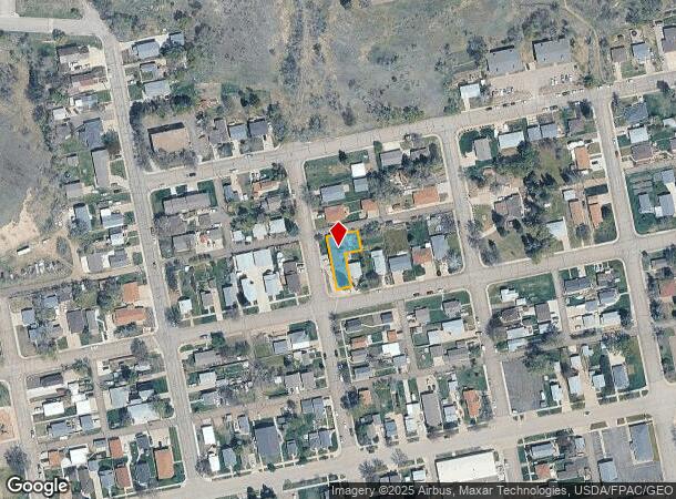
Property Record
304 10Th Ave Ne, Mandan, ND 58554
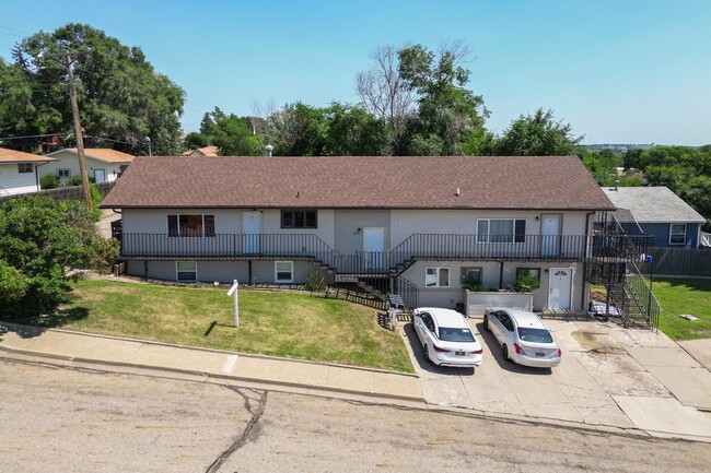
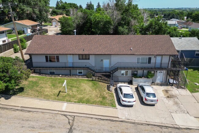
This Property Is For Sale
NEARBY LISTINGS FOR SALE OR LEASE
Property Detail
304 10Th Ave Ne
Other Market Areas
Helmsworth-Mcleans Addition
Bismarck, ND
Morton
65-1475000
North Dakota
Residentialnec
0.19 AC
X
Downtown Mandan
38015C0760E
DEMOGRAPHICS near 304 10Th Ave Ne
1 Mile
3 Mile
5 Mile
2024 Total Population
6,950
24,945
66,178
2029 Population
7,048
25,486
67,931
Pop Growth 2024-2029
+ 1.41%
+ 2.17%
+ 2.65%
Average Age
40
40
41
2024 Total Households
3,079
10,336
28,305
HH Growth 2024-2029
+ 1.27%
+ 2.18%
+ 2.91%
Median Household Inc
$72,079
$86,810
$87,094
Avg Household Size
2.20
2.30
2.20
2024 Avg HH Vehicles
2.00
2.00
2.00
Median Home Value
$212,401
$272,467
$294,774
Median Year Built
1972
1981
1981
Nearby Places
- Restaurants
- Banks
- Shops
- Fitness
- Groceries
PUBLIC TRANSPORTATION
AIRPORT
Bismarck Municipal
DRIVE
WALK
Distance
Bismarck Municipal
23 min
9.4 mi
Nearby Properties
Address
Land Use
TOTAL SIZE
Lot Size
Zoning
Address
Land Use
TOTAL SIZE
Lot Size
Zoning
13.98 AC
CG
Address
Land Use
TOTAL SIZE
Lot Size
Zoning
8.64 AC
ETZ
Address
Land Use
TOTAL SIZE
Lot Size
Zoning
28,802 SF
1.82 AC
CG
Address
Land Use
TOTAL SIZE
Lot Size
Zoning
43,708 SF
3.87 AC
CG
Address
Land Use
TOTAL SIZE
Lot Size
Zoning
24,283 SF
2.02 AC
RT
Address
Land Use
TOTAL SIZE
Lot Size
Zoning
2.08 AC
ETZ
Address
Land Use
TOTAL SIZE
Lot Size
Zoning
60,582 SF
2.21 AC
CG
Address
Land Use
TOTAL SIZE
Lot Size
Zoning
1.91 AC
ETZ
Address
Land Use
TOTAL SIZE
Lot Size
Zoning
0.72 AC
ETZ
Address
Land Use
TOTAL SIZE
Lot Size
Zoning
Address
Land Use
TOTAL SIZE
Lot Size
Zoning
12,696 SF
1.33 AC
CG
Address
Land Use
TOTAL SIZE
Lot Size
Zoning
1.40 AC
ETZ
Address
Land Use
TOTAL SIZE
Lot Size
Zoning
Address
Land Use
TOTAL SIZE
Lot Size
Zoning
7,882 SF
2.33 AC
CG
Address
Land Use
TOTAL SIZE
Lot Size
Zoning
8.99 AC
ETZ
Address
Land Use
TOTAL SIZE
Lot Size
Zoning
15,969 SF
1.69 AC
RT
Address
Land Use
TOTAL SIZE
Lot Size
Zoning
9,892 SF
3.30 AC
CG
Address
Land Use
TOTAL SIZE
Lot Size
Zoning
11,714 SF
1.88 AC
RT
Address
Land Use
TOTAL SIZE
Lot Size
Zoning
4,923 SF
1.77 AC
CG
Address
Land Use
TOTAL SIZE
Lot Size
Zoning
7,113 SF
2.27 AC
CG
Address
Land Use
TOTAL SIZE
Lot Size
Zoning
7,641 SF
1.94 AC
CG
Address
Land Use
TOTAL SIZE
Lot Size
Zoning
5,668 SF
1.29 AC
CG
Address
Land Use
TOTAL SIZE
Lot Size
Zoning
3,902 SF
1.55 AC
CA
Address
Land Use
TOTAL SIZE
Lot Size
Zoning
12,248 SF
0.95 AC
CG
Address
Land Use
TOTAL SIZE
Lot Size
Zoning
6,377 SF
1.85 AC
RT
Address
Land Use
TOTAL SIZE
Lot Size
Zoning
6,255 SF
1 AC
CG
Address
Land Use
TOTAL SIZE
Lot Size
Zoning
8,354 SF
1.33 AC
RT
Address
Land Use
TOTAL SIZE
Lot Size
Zoning
5,552 SF
1.72 AC
RT
Address
Land Use
TOTAL SIZE
Lot Size
Zoning
Address
Land Use
TOTAL SIZE
Lot Size
Zoning
1.20 AC
ETZ
The World's #1 Commercial Real Estate Marketplace
Connect with us
© 2025 CoStar Group
The information above has been obtained from sources believed reliable. While we do not doubt its accuracy we have not verified it and make no guarantee, warranty or representation about it. It is your responsibility to independently confirm its accuracy and completeness. Any projections, opinions, assumptions, or estimates used are for example only and do not represent the current or future performance of the property. The value of this transaction to you depends on tax and other factors which should be evaluated by your tax, financial, and legal advisors. You and your advisors should conduct a careful, independent investigation of the property to determine to your satisfaction the suitability of the property for your needs.