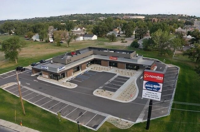
Property Record
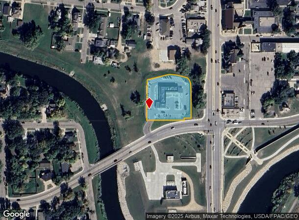
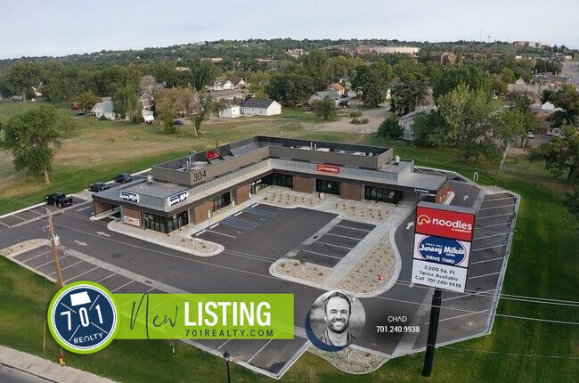
304 4Th Ave Nw, Minot, ND 58703
NEARBY LISTINGS FOR SALE OR LEASE
Property Detail
304 4Th Ave Nw
Other Market Areas
The Mchenry Add
Minot, ND
SUB: MI14F55 LOT: 1 THE MCHENRY ADDITION LOT 1
MI14F550000010
Ward
Commercialacreage
North Dakota
2024
1
2024
1.24 AC
010400
Downtown Minot
5,705 SF
DEMOGRAPHICS near 304 4Th Ave Nw
1 Mile
3 Mile
5 Mile
2024 Total Population
10,642
45,311
52,733
2029 Population
10,494
44,675
51,947
Pop Growth 2024-2029
(1.39%)
(1.40%)
(1.49%)
Average Age
36
38
38
2024 Total Households
4,512
19,602
22,563
HH Growth 2024-2029
(1.53%)
(1.46%)
(1.54%)
Median Household Inc
$64,043
$68,273
$69,290
Avg Household Size
2.10
2.20
2.20
2024 Avg HH Vehicles
2.00
2.00
2.00
Median Home Value
$193,387
$230,629
$237,756
Median Year Built
1963
1982
1983
Nearby Places
Map Layers
Map Styles
 Street
 Aerial
- Restaurants
- Banks
- Shops
- Fitness
- Groceries
PUBLIC TRANSPORTATION
COMMUTER RAIL
Minot Amtrak Station (Empire Builder - Amtrak)
DRIVE
WALK
Distance
Minot Amtrak Station (Empire Builder - Amtrak)
1 min
13 min
0.6 mi
AIRPORT
Minot International
DRIVE
WALK
Distance
Minot International
5 min
2.0 mi
Freight Ports
Port Milwaukee
DRIVE
WALK
Distance
Port Milwaukee
944 min
871.9 mi
SALE & LEASE HISTORY
LISTING DATE
SALE/LEASE

Nov 01, 2021
For Lease
Feb 01, 2017
For Sale
Nearby Properties
Address
Land Use
TOTAL SIZE
Lot Size
Zoning
Address
Land Use
TOTAL SIZE
Lot Size
Zoning
142,655 SF
9.54 AC
Address
Land Use
TOTAL SIZE
Lot Size
Zoning
55,908 SF
5.89 AC
Address
Land Use
TOTAL SIZE
Lot Size
Zoning
121,307 SF
2.97 AC
Address
Land Use
TOTAL SIZE
Lot Size
Zoning
29,172 SF
9.19 AC
Address
Land Use
TOTAL SIZE
Lot Size
Zoning
41,710 SF
2.45 AC
Address
Land Use
TOTAL SIZE
Lot Size
Zoning
14,400 SF
4.46 AC
Address
Land Use
TOTAL SIZE
Lot Size
Zoning
39,667 SF
0.02 AC
Address
Land Use
TOTAL SIZE
Lot Size
Zoning
13.96 AC
Address
Land Use
TOTAL SIZE
Lot Size
Zoning
4,000 SF
59.25 AC
Address
Land Use
TOTAL SIZE
Lot Size
Zoning
45,052 SF
3.78 AC
Address
Land Use
TOTAL SIZE
Lot Size
Zoning
46,496 SF
2.41 AC
Address
Land Use
TOTAL SIZE
Lot Size
Zoning
47,150 SF
6.43 AC
Address
Land Use
TOTAL SIZE
Lot Size
Zoning
30,000 SF
8.53 AC
Address
Land Use
TOTAL SIZE
Lot Size
Zoning
24,471 SF
1.54 AC
Address
Land Use
TOTAL SIZE
Lot Size
Zoning
31,924 SF
2.82 AC
Address
Land Use
TOTAL SIZE
Lot Size
Zoning
9.49 AC
Address
Land Use
TOTAL SIZE
Lot Size
Zoning
55,520 SF
2.50 AC
Address
Land Use
TOTAL SIZE
Lot Size
Zoning
8,060 SF
1.02 AC
Address
Land Use
TOTAL SIZE
Lot Size
Zoning
6,868 SF
1.52 AC
Address
Land Use
TOTAL SIZE
Lot Size
Zoning
14,112 SF
1.71 AC
Address
Land Use
TOTAL SIZE
Lot Size
Zoning
36,633 SF
2.07 AC
Address
Land Use
TOTAL SIZE
Lot Size
Zoning
24,110 SF
5.83 AC
Address
Land Use
TOTAL SIZE
Lot Size
Zoning
36,158 SF
Address
Land Use
TOTAL SIZE
Lot Size
Zoning
7,200 SF
1.10 AC
Address
Land Use
TOTAL SIZE
Lot Size
Zoning
6,120 SF
0.53 AC
Address
Land Use
TOTAL SIZE
Lot Size
Zoning
9,715 SF
0.86 AC
The World's #1 Commercial Real Estate Marketplace
Connect with us
© 2026 CoStar Group
The information above has been obtained from sources believed reliable. While we do not doubt its accuracy we have not verified it and make no guarantee, warranty or representation about it. It is your responsibility to independently confirm its accuracy and completeness. Any projections, opinions, assumptions, or estimates used are for example only and do not represent the current or future performance of the property. The value of this transaction to you depends on tax and other factors which should be evaluated by your tax, financial, and legal advisors. You and your advisors should conduct a careful, independent investigation of the property to determine to your satisfaction the suitability of the property for your needs.