Property Record
304 Arlington Ave, Berkeley, CA 94707
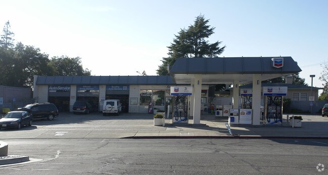

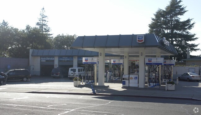
Property Detail
304 Arlington Ave
571-050-021-5
KENSINGTON PARK LOT 3 & POR 4 BLK 2
Servicestation
CONTRA COSTA
RB
California
B and X Area of moderate flood hazard, usually the area between the limits of the 100-year and 500-year floods.
3
2025
0.28 AC
2025
Berkeley
391000
East Bay/Oakland
2,072 SF
Oakland-Fremont-Berkeley, CA
NEARBY LISTINGS FOR SALE OR LEASE
DEMOGRAPHICS near 304 Arlington Ave
1 mile
3 mile
5 mile
2025 Total Population
18,693
155,208
322,709
2030 Population
18,612
155,765
323,910
Pop Growth 2025-2030
(0.43%)
+ 0.36%
+ 0.37%
Average Age
48
40
40
2025 Total Households
7,537
59,256
124,353
HH Growth 2025-2030
(0.52%)
+ 0.50%
+ 0.41%
Median Household Inc
$199,094
$109,292
$112,838
Avg Household Size
2.50
2.30
2.40
2025 Avg HH Vehicles
2.00
1.00
2.00
Median Home Value
$1,126,238
$1,083,136
$1,027,626
Median Year Built
1946
1953
1955
Nearby Places
Map Layers
Map Styles
 Street
 Aerial
Transit
 Traffic
 Biking
Places
Listings with unknown addresses are not visible on the map
- Restaurants
- Banks
- Shops
- Fitness
- Groceries
PUBLIC TRANSPORTATION
COMMUTER RAIL
Drive
Walk
Distance
12 min
4.9 mi
Drive
Walk
Distance
14 min
6.2 mi
AIRPORT
Metro Oakland International
Drive
Walk
Distance
Metro Oakland International
33 min
19.8 mi
San Francisco International
Drive
Walk
Distance
San Francisco International
45 min
27.3 mi
Freight Ports
Port of Richmond
Drive
Walk
Distance
Port of Richmond
21 min
9.7 mi
Nearby Properties
Address
Land Use
TOTAL SIZE
Lot Size
Zoning
Address
Land Use
TOTAL SIZE
Lot Size
Zoning
167,071 SF
0.70 AC
Address
Land Use
TOTAL SIZE
Lot Size
Zoning
4.77 AC
Address
Land Use
TOTAL SIZE
Lot Size
Zoning
309,451 SF
0.87 AC
Address
Land Use
TOTAL SIZE
Lot Size
Zoning
123,750 SF
0.81 AC
Address
Land Use
TOTAL SIZE
Lot Size
Zoning
254,000 SF
1.71 AC
Address
Land Use
TOTAL SIZE
Lot Size
Zoning
166,731 SF
0.54 AC
Address
Land Use
TOTAL SIZE
Lot Size
Zoning
86,144 SF
0.52 AC
Address
Land Use
TOTAL SIZE
Lot Size
Zoning
159,705 SF
1.64 AC
COMM
Address
Land Use
TOTAL SIZE
Lot Size
Zoning
65,839 SF
0.62 AC
C2
Address
Land Use
TOTAL SIZE
Lot Size
Zoning
12.31 AC
Address
Land Use
TOTAL SIZE
Lot Size
Zoning
0.61 AC
Address
Land Use
TOTAL SIZE
Lot Size
Zoning
3.61 AC
Address
Land Use
TOTAL SIZE
Lot Size
Zoning
30,500 SF
0.24 AC
R4
Address
Land Use
TOTAL SIZE
Lot Size
Zoning
67,558 SF
0.32 AC
Address
Land Use
TOTAL SIZE
Lot Size
Zoning
136,811 SF
1.01 AC
Address
Land Use
TOTAL SIZE
Lot Size
Zoning
83,874 SF
0.60 AC
Address
Land Use
TOTAL SIZE
Lot Size
Zoning
81,410 SF
0.51 AC
Address
Land Use
TOTAL SIZE
Lot Size
Zoning
63,982 SF
0.44 AC
Address
Land Use
TOTAL SIZE
Lot Size
Zoning
75,558 SF
0.52 AC
Address
Land Use
TOTAL SIZE
Lot Size
Zoning
66,235 SF
0.46 AC
Address
Land Use
TOTAL SIZE
Lot Size
Zoning
108,048 SF
1 AC
Address
Land Use
TOTAL SIZE
Lot Size
Zoning
191,800 SF
1.09 AC
Address
Land Use
TOTAL SIZE
Lot Size
Zoning
81,149 SF
1.87 AC
Address
Land Use
TOTAL SIZE
Lot Size
Zoning
83,538 SF
0.60 AC
Address
Land Use
TOTAL SIZE
Lot Size
Zoning
139,929 SF
0.51 AC
Address
Land Use
TOTAL SIZE
Lot Size
Zoning
124,257 SF
2.72 AC
Address
Land Use
TOTAL SIZE
Lot Size
Zoning
62,050 SF
0.38 AC
Address
Land Use
TOTAL SIZE
Lot Size
Zoning
47,575 SF
1.79 AC
Address
Land Use
TOTAL SIZE
Lot Size
Zoning
3,600 SF
0.28 AC
Address
Land Use
TOTAL SIZE
Lot Size
Zoning
45,836 SF
0.39 AC
The World's #1 Commercial Real Estate Marketplace
Connect with us
© 2026 CoStar Group
The information above has been obtained from sources believed reliable. While we do not doubt its accuracy we have not verified it and make no guarantee, warranty or representation about it. It is your responsibility to independently confirm its accuracy and completeness. Any projections, opinions, assumptions, or estimates used are for example only and do not represent the current or future performance of the property. The value of this transaction to you depends on tax and other factors which should be evaluated by your tax, financial, and legal advisors. You and your advisors should conduct a careful, independent investigation of the property to determine to your satisfaction the suitability of the property for your needs.