Property Record
304 Raymond Rd, Candia, NH 03034
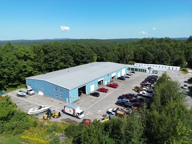

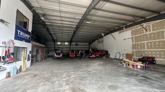
This Property Is For Sale
Property Detail
304 Raymond Rd
CAND-000409-000116-000001
Rockingham
Commercialnec
New Hampshire
3
1
B and X Area of moderate flood hazard, usually the area between the limits of the 100-year and 500-year floods.
19.98 AC
2025
Rockingham
2025
Boston
050000
Boston-Cambridge-Newton, MA-NH
20,000 SF
NEARBY LISTINGS FOR SALE OR LEASE
-
-
View all Candia listings for sale on LoopNet.com
DEMOGRAPHICS near 304 Raymond Rd
1 mile
3 mile
5 mile
2025 Total Population
303
5,157
14,168
2030 Population
301
5,208
14,379
Pop Growth 2025-2030
(0.66%)
+ 0.99%
+ 1.49%
Average Age
45
45
44
2025 Total Households
117
2,017
5,428
HH Growth 2025-2030
(0.85%)
+ 0.99%
+ 1.44%
Median Household Inc
$128,750
$114,601
$114,372
Avg Household Size
2.60
2.50
2.60
2025 Avg HH Vehicles
3.00
2.00
2.00
Median Home Value
$467,241
$406,651
$417,713
Median Year Built
1948
1978
1980
Nearby Places
Map Layers
Map Styles
 Street
 Aerial
Layers
 Traffic
 Biking
Places
Listings with unknown addresses are not visible on the map
- Restaurants
- Banks
- Shops
- Fitness
- Groceries
PUBLIC TRANSPORTATION
AIRPORT
Manchester Boston Regional
Drive
Walk
Distance
Manchester Boston Regional
29 min
17.1 mi
Portsmouth International at Pease
Drive
Walk
Distance
Portsmouth International at Pease
52 min
31.8 mi
Freight Ports
Port of Boston
Drive
Walk
Distance
Port of Boston
92 min
61.1 mi
Nearby Properties
Address
Land Use
TOTAL SIZE
Lot Size
Zoning
Address
Land Use
TOTAL SIZE
Lot Size
Zoning
45,952 SF
16.07 AC
5
Address
Land Use
TOTAL SIZE
Lot Size
Zoning
936 SF
89 AC
C1
Address
Land Use
TOTAL SIZE
Lot Size
Zoning
8.62 AC
C1
Address
Land Use
TOTAL SIZE
Lot Size
Zoning
23,340 SF
9 AC
C1
Address
Land Use
TOTAL SIZE
Lot Size
Zoning
8,498 SF
13.86 AC
4
Address
Land Use
TOTAL SIZE
Lot Size
Zoning
3.30 AC
2
Address
Land Use
TOTAL SIZE
Lot Size
Zoning
1,500 SF
180 AC
B
Address
Land Use
TOTAL SIZE
Lot Size
Zoning
10.11 AC
1
Address
Land Use
TOTAL SIZE
Lot Size
Zoning
42.49 AC
3
Address
Land Use
TOTAL SIZE
Lot Size
Zoning
11.23 AC
1
Address
Land Use
TOTAL SIZE
Lot Size
Zoning
21.62 AC
2
Address
Land Use
TOTAL SIZE
Lot Size
Zoning
14,736 SF
13.45 AC
1
Address
Land Use
TOTAL SIZE
Lot Size
Zoning
8,528 SF
5.14 AC
2
Address
Land Use
TOTAL SIZE
Lot Size
Zoning
3,734 SF
0.64 AC
5
Address
Land Use
TOTAL SIZE
Lot Size
Zoning
26,386 SF
5.47 AC
3
Address
Land Use
TOTAL SIZE
Lot Size
Zoning
9,950 SF
2.53 AC
2
Address
Land Use
TOTAL SIZE
Lot Size
Zoning
6,731 SF
9.14 AC
5
Address
Land Use
TOTAL SIZE
Lot Size
Zoning
18,884 SF
45.17 AC
1
Address
Land Use
TOTAL SIZE
Lot Size
Zoning
4,382 SF
105.50 AC
AR AGR
Address
Land Use
TOTAL SIZE
Lot Size
Zoning
1,720 SF
5.13 AC
2
Address
Land Use
TOTAL SIZE
Lot Size
Zoning
6,370 SF
3.95 AC
1
Address
Land Use
TOTAL SIZE
Lot Size
Zoning
8.70 AC
5
Address
Land Use
TOTAL SIZE
Lot Size
Zoning
4,561 SF
7.92 AC
AR AGR
Address
Land Use
TOTAL SIZE
Lot Size
Zoning
3.50 AC
1
Address
Land Use
TOTAL SIZE
Lot Size
Zoning
5,773 SF
2.50 AC
AR AGR
Address
Land Use
TOTAL SIZE
Lot Size
Zoning
12,420 SF
15 AC
C1
Address
Land Use
TOTAL SIZE
Lot Size
Zoning
3,989 SF
6.23 AC
AR AGR
Address
Land Use
TOTAL SIZE
Lot Size
Zoning
6.64 AC
1
Address
Land Use
TOTAL SIZE
Lot Size
Zoning
0.43 AC
6
The World's #1 Commercial Real Estate Marketplace
Connect with us
© 2026 CoStar Group
The information above has been obtained from sources believed reliable. While we do not doubt its accuracy we have not verified it and make no guarantee, warranty or representation about it. It is your responsibility to independently confirm its accuracy and completeness. Any projections, opinions, assumptions, or estimates used are for example only and do not represent the current or future performance of the property. The value of this transaction to you depends on tax and other factors which should be evaluated by your tax, financial, and legal advisors. You and your advisors should conduct a careful, independent investigation of the property to determine to your satisfaction the suitability of the property for your needs.