Property Record
304 Rt 34, Colts Neck, NJ 07722
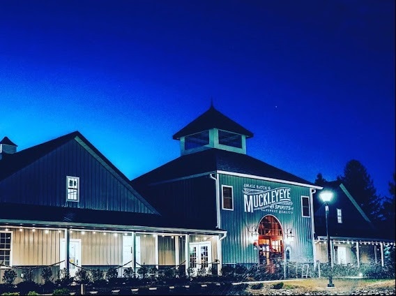

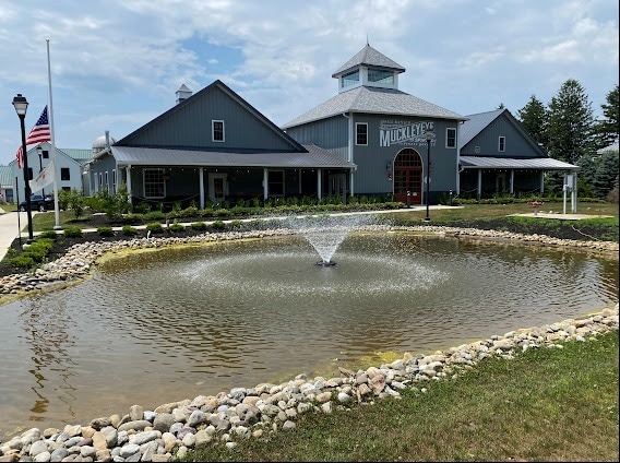
This Property Is For Sale
Property Detail
304 Rt 34
10-00046-0000-00017-14
MONMOUTH
Winery
New Jersey
B-3
17.14
AE The base floodplain where base flood elevations are provided. AE Zones are now used on new format FIRMs instead of A1-A30 Zones.
1 AC
2024
Western Monmouth
2025
Northern New Jersey
809901
Lakewood-New Brunswick, NJ
5,114 SF
NEARBY LISTINGS FOR SALE OR LEASE
DEMOGRAPHICS near 304 Rt 34
1 mile
3 mile
5 mile
2025 Total Population
1,179
7,912
44,384
2030 Population
1,195
7,919
44,163
Pop Growth 2025-2030
+ 1.36%
+ 0.09%
(0.50%)
Average Age
40
42
42
2025 Total Households
380
2,599
15,247
HH Growth 2025-2030
+ 1.32%
(0.08%)
(0.75%)
Median Household Inc
$167,073
$190,766
$173,657
Avg Household Size
3.10
3.00
2.80
2025 Avg HH Vehicles
2.00
2.00
2.00
Median Home Value
$952,302
$893,029
$752,806
Median Year Built
1988
1984
1986
Nearby Places
Map Layers
Map Styles
 Street
 Aerial
Layers
 Traffic
 Biking
Places
Listings with unknown addresses are not visible on the map
- Restaurants
- Banks
- Shops
- Fitness
- Groceries
PUBLIC TRANSPORTATION
COMMUTER RAIL
Little Silver (North Jersey Coast Line - NJ Transit Commuter Rail (NJ Transit))
Drive
Walk
Distance
Little Silver (North Jersey Coast Line - NJ Transit Commuter Rail (NJ Transit))
16 min
9.3 mi
Red Bank (North Jersey Coast Line - NJ Transit Commuter Rail (NJ Transit))
Drive
Walk
Distance
Red Bank (North Jersey Coast Line - NJ Transit Commuter Rail (NJ Transit))
16 min
9.5 mi
AIRPORT
Newark Liberty International
Drive
Walk
Distance
Newark Liberty International
53 min
44.1 mi
Freight Ports
New York Container Terminal
Drive
Walk
Distance
New York Container Terminal
46 min
36.3 mi
Nearby Properties
Address
Land Use
TOTAL SIZE
Lot Size
Zoning
Address
Land Use
TOTAL SIZE
Lot Size
Zoning
3.65 AC
SF80
Address
Land Use
TOTAL SIZE
Lot Size
Zoning
3,255.78 AC
ARE6
Address
Land Use
TOTAL SIZE
Lot Size
Zoning
69.99 AC
SF80
Address
Land Use
TOTAL SIZE
Lot Size
Zoning
241.06 AC
AG
Address
Land Use
TOTAL SIZE
Lot Size
Zoning
1.06 AC
SF80
Address
Land Use
TOTAL SIZE
Lot Size
Zoning
22.95 AC
A-1
Address
Land Use
TOTAL SIZE
Lot Size
Zoning
647.36 AC
HD03
Address
Land Use
TOTAL SIZE
Lot Size
Zoning
18,128 SF
6 AC
Address
Land Use
TOTAL SIZE
Lot Size
Zoning
3,663 SF
179.80 AC
SF80
Address
Land Use
TOTAL SIZE
Lot Size
Zoning
13,365 SF
3 AC
AG
Address
Land Use
TOTAL SIZE
Lot Size
Zoning
39,321 SF
6.77 AC
C125
Address
Land Use
TOTAL SIZE
Lot Size
Zoning
6,072 SF
31.59 AC
OB0
Address
Land Use
TOTAL SIZE
Lot Size
Zoning
17,199 SF
4 AC
Address
Land Use
TOTAL SIZE
Lot Size
Zoning
27.87 AC
A-1
Address
Land Use
TOTAL SIZE
Lot Size
Zoning
15.17 AC
SF80
Address
Land Use
TOTAL SIZE
Lot Size
Zoning
10,734 SF
25.16 AC
SF80
Address
Land Use
TOTAL SIZE
Lot Size
Zoning
154,800 SF
19.25 AC
ROWL10
Address
Land Use
TOTAL SIZE
Lot Size
Zoning
50,565 SF
4 AC
B
Address
Land Use
TOTAL SIZE
Lot Size
Zoning
33,408 SF
8.27 AC
B-1
Address
Land Use
TOTAL SIZE
Lot Size
Zoning
17,296 SF
12.54 AC
AG
Address
Land Use
TOTAL SIZE
Lot Size
Zoning
16,997 SF
4.30 AC
C125
Address
Land Use
TOTAL SIZE
Lot Size
Zoning
13,103 SF
2 AC
Address
Land Use
TOTAL SIZE
Lot Size
Zoning
163.69 AC
AG
Address
Land Use
TOTAL SIZE
Lot Size
Zoning
38.92 AC
AGCL
Address
Land Use
TOTAL SIZE
Lot Size
Zoning
10,907 SF
3.89 AC
Address
Land Use
TOTAL SIZE
Lot Size
Zoning
11,390 SF
1 AC
SF80
Address
Land Use
TOTAL SIZE
Lot Size
Zoning
5,000 SF
61.09 AC
SF80
Address
Land Use
TOTAL SIZE
Lot Size
Zoning
89.75 AC
SF80
Address
Land Use
TOTAL SIZE
Lot Size
Zoning
3,328 SF
133.38 AC
SF80
Address
Land Use
TOTAL SIZE
Lot Size
Zoning
10,284 SF
16.04 AC
AG
The World's #1 Commercial Real Estate Marketplace
Connect with us
© 2026 CoStar Group
The information above has been obtained from sources believed reliable. While we do not doubt its accuracy we have not verified it and make no guarantee, warranty or representation about it. It is your responsibility to independently confirm its accuracy and completeness. Any projections, opinions, assumptions, or estimates used are for example only and do not represent the current or future performance of the property. The value of this transaction to you depends on tax and other factors which should be evaluated by your tax, financial, and legal advisors. You and your advisors should conduct a careful, independent investigation of the property to determine to your satisfaction the suitability of the property for your needs.