Property Record
304 S Randy Lowery Rd, Statesboro, GA 30461

NEARBY LISTINGS FOR SALE OR LEASE
Property Detail
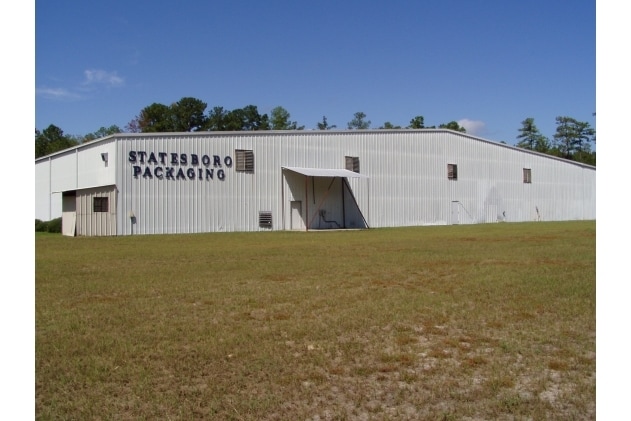
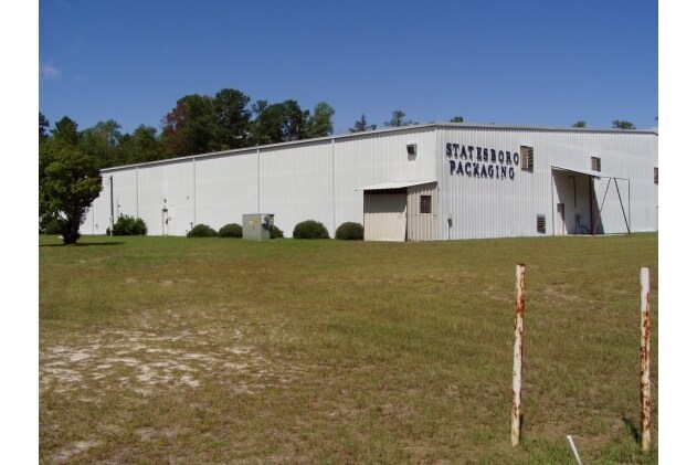
304 S Randy Lowery Rd
MS79000004-000
5.50 AC/HOLLAND LOT 19
Commercialnec
Bulloch
X
Georgia
13031C0207D
19
2024
5.50 AC
2025
Georgia South Area
110201
Other Market Areas
70,000 SF
Statesboro, GA
DEMOGRAPHICS near 304 S Randy Lowery Rd
1 Mile
3 Mile
5 Mile
2024 Total Population
182
12,868
33,530
2029 Population
202
14,261
36,735
Pop Growth 2024-2029
+ 10.99%
+ 10.83%
+ 9.56%
Average Age
38
37
35
2024 Total Households
59
5,078
12,663
HH Growth 2024-2029
+ 11.86%
+ 11.58%
+ 10.48%
Median Household Inc
$59,166
$50,716
$52,316
Avg Household Size
2.70
2.40
2.30
2024 Avg HH Vehicles
2.00
2.00
2.00
Median Home Value
$173,529
$179,936
$183,174
Median Year Built
1987
1988
1987
Nearby Places
Map Layers
Map Styles
 Street
 Aerial
- Restaurants
- Banks
- Shops
- Fitness
- Groceries
Nearby Properties
Address
Land Use
TOTAL SIZE
Lot Size
Zoning
Address
Land Use
TOTAL SIZE
Lot Size
Zoning
1,280 SF
792.45 AC
LI
Address
Land Use
TOTAL SIZE
Lot Size
Zoning
41.09 AC
R3/R15
Address
Land Use
TOTAL SIZE
Lot Size
Zoning
950 SF
12.73 AC
PUD/R4
Address
Land Use
TOTAL SIZE
Lot Size
Zoning
153.74 AC
R40
Address
Land Use
TOTAL SIZE
Lot Size
Zoning
13 AC
R20
Address
Land Use
TOTAL SIZE
Lot Size
Zoning
13,820 SF
5.14 AC
CR
Address
Land Use
TOTAL SIZE
Lot Size
Zoning
4,248 SF
19.24 AC
R40
Address
Land Use
TOTAL SIZE
Lot Size
Zoning
52.59 AC
HC/R-80
Address
Land Use
TOTAL SIZE
Lot Size
Zoning
70,000 SF
12 AC
R4/HOC
Address
Land Use
TOTAL SIZE
Lot Size
Zoning
1,893 SF
10.73 AC
R4
Address
Land Use
TOTAL SIZE
Lot Size
Zoning
40,517 SF
12.42 AC
R4
Address
Land Use
TOTAL SIZE
Lot Size
Zoning
52,320 SF
7.36 AC
R4
Address
Land Use
TOTAL SIZE
Lot Size
Zoning
1,036 SF
11.70 AC
R4
Address
Land Use
TOTAL SIZE
Lot Size
Zoning
953 SF
4.89 AC
PUD/R4
Address
Land Use
TOTAL SIZE
Lot Size
Zoning
5 AC
R20
Address
Land Use
TOTAL SIZE
Lot Size
Zoning
112,500 SF
4.91 AC
HOC/LI
Address
Land Use
TOTAL SIZE
Lot Size
Zoning
852 SF
4.28 AC
R4/LI
Address
Land Use
TOTAL SIZE
Lot Size
Zoning
2,276 SF
11.34 AC
R4
Address
Land Use
TOTAL SIZE
Lot Size
Zoning
71,195 SF
1.88 AC
R4
Address
Land Use
TOTAL SIZE
Lot Size
Zoning
176,166 SF
24.70 AC
LI
Address
Land Use
TOTAL SIZE
Lot Size
Zoning
20,877 SF
2.17 AC
CBD
Address
Land Use
TOTAL SIZE
Lot Size
Zoning
50,803 SF
6 AC
LI
Address
Land Use
TOTAL SIZE
Lot Size
Zoning
1,764 SF
39.97 AC
HOC/R4
Address
Land Use
TOTAL SIZE
Lot Size
Zoning
45,599 SF
4.38 AC
LI/R15
Address
Land Use
TOTAL SIZE
Lot Size
Zoning
5,512 SF
1.30 AC
HOC
Address
Land Use
TOTAL SIZE
Lot Size
Zoning
16.94 AC
R15
Address
Land Use
TOTAL SIZE
Lot Size
Zoning
9,600 SF
15 AC
R80
Address
Land Use
TOTAL SIZE
Lot Size
Zoning
4.84 AC
R15
Address
Land Use
TOTAL SIZE
Lot Size
Zoning
12,814 SF
1.94 AC
HC
Address
Land Use
TOTAL SIZE
Lot Size
Zoning
2.62 AC
CR
The World's #1 Commercial Real Estate Marketplace
Connect with us
© 2026 CoStar Group
The information above has been obtained from sources believed reliable. While we do not doubt its accuracy we have not verified it and make no guarantee, warranty or representation about it. It is your responsibility to independently confirm its accuracy and completeness. Any projections, opinions, assumptions, or estimates used are for example only and do not represent the current or future performance of the property. The value of this transaction to you depends on tax and other factors which should be evaluated by your tax, financial, and legal advisors. You and your advisors should conduct a careful, independent investigation of the property to determine to your satisfaction the suitability of the property for your needs.