Property Record
3041 S Pine Ave, Ocala, FL 34471
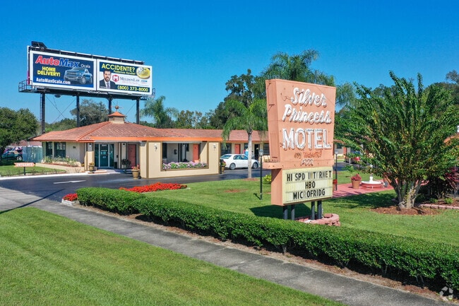


This Property Is For Sale
Property Detail
3041 S Pine Ave
3029-002-003
SEC 29 TWP 15 RGE 22 PLAT BOOK F PAGE 002 SOUTHWOOD BLK B LOTS 2.3.4 & 5 EXC COM AT THE SW COR OF LOT 2 TH S 39-23-23 E ALONG THE NLY ROW LINE OF US HWY 441 39.75 FT TH N 52-00-25 E 217.43 FT TO THE NELY BDY LINE OF LOT 2 TH N 38-42-10 W ALONG SAID N
Motel
Marion
B4
Florida
B and X Area of moderate flood hazard, usually the area between the limits of the 100-year and 500-year floods.
2
2025
1.71 AC
2025
Ocala
002303
Ocala
7,974 SF
Ocala, FL
NEARBY LISTINGS FOR SALE OR LEASE
-
-
View all Ocala listings for sale on LoopNet.com
DEMOGRAPHICS near 3041 S Pine Ave
1 mile
3 mile
5 mile
2025 Total Population
5,879
43,210
99,060
2030 Population
6,597
48,443
110,946
Pop Growth 2025-2030
+ 12.21%
+ 12.11%
+ 12.00%
Average Age
43
41
40
2025 Total Households
2,427
17,793
39,702
HH Growth 2025-2030
+ 12.73%
+ 12.48%
+ 12.36%
Median Household Inc
$57,736
$56,560
$59,375
Avg Household Size
2.20
2.30
2.40
2025 Avg HH Vehicles
2.00
2.00
2.00
Median Home Value
$285,436
$314,936
$284,159
Median Year Built
1983
1981
1984
Nearby Places
Map Layers
Map Styles
 Street
 Aerial
Transit
 Traffic
 Biking
Places
Listings with unknown addresses are not visible on the map
- Restaurants
- Banks
- Shops
- Fitness
- Groceries
Nearby Properties
Address
Land Use
TOTAL SIZE
Lot Size
Zoning
Address
Land Use
TOTAL SIZE
Lot Size
Zoning
207,950 SF
14.08 AC
INST
Address
Land Use
TOTAL SIZE
Lot Size
Zoning
331,687 SF
11.66 AC
INST
Address
Land Use
TOTAL SIZE
Lot Size
Zoning
446,764 SF
138.06 AC
GU
Address
Land Use
TOTAL SIZE
Lot Size
Zoning
189,025 SF
35.42 AC
PD08
Address
Land Use
TOTAL SIZE
Lot Size
Zoning
195,992 SF
5.72 AC
FBC
Address
Land Use
TOTAL SIZE
Lot Size
Zoning
422,264 SF
40.87 AC
SC
Address
Land Use
TOTAL SIZE
Lot Size
Zoning
154,675 SF
23.62 AC
PD09
Address
Land Use
TOTAL SIZE
Lot Size
Zoning
178,015 SF
18.28 AC
PD07
Address
Land Use
TOTAL SIZE
Lot Size
Zoning
111,644 SF
19 AC
PD09
Address
Land Use
TOTAL SIZE
Lot Size
Zoning
222,210 SF
22.14 AC
SC
Address
Land Use
TOTAL SIZE
Lot Size
Zoning
92,049 SF
15.75 AC
R3
Address
Land Use
TOTAL SIZE
Lot Size
Zoning
110,226 SF
19.56 AC
PD09
Address
Land Use
TOTAL SIZE
Lot Size
Zoning
266,503 SF
25.48 AC
SC
Address
Land Use
TOTAL SIZE
Lot Size
Zoning
88,462 SF
31.76 AC
INST
Address
Land Use
TOTAL SIZE
Lot Size
Zoning
89,719 SF
15.16 AC
PD12
Address
Land Use
TOTAL SIZE
Lot Size
Zoning
80,532 SF
53.56 AC
INST
Address
Land Use
TOTAL SIZE
Lot Size
Zoning
76,062 SF
23.73 AC
B4
Address
Land Use
TOTAL SIZE
Lot Size
Zoning
30,274 SF
3.94 AC
FBC
Address
Land Use
TOTAL SIZE
Lot Size
Zoning
56,484 SF
12.50 AC
PD14
Address
Land Use
TOTAL SIZE
Lot Size
Zoning
234,097 SF
22.89 AC
SC
Address
Land Use
TOTAL SIZE
Lot Size
Zoning
65,882 SF
13.34 AC
R3
Address
Land Use
TOTAL SIZE
Lot Size
Zoning
111,395 SF
13 AC
B2
Address
Land Use
TOTAL SIZE
Lot Size
Zoning
180,334 SF
24.29 AC
INST
Address
Land Use
TOTAL SIZE
Lot Size
Zoning
101,892 SF
16.81 AC
INST
Address
Land Use
TOTAL SIZE
Lot Size
Zoning
95,552 SF
11.31 AC
SC
Address
Land Use
TOTAL SIZE
Lot Size
Zoning
69,607 SF
6.74 AC
INST
Address
Land Use
TOTAL SIZE
Lot Size
Zoning
78,719 SF
7.42 AC
PD09
Address
Land Use
TOTAL SIZE
Lot Size
Zoning
78,410 SF
9.13 AC
PD
Address
Land Use
TOTAL SIZE
Lot Size
Zoning
19,117 SF
0.98 AC
FBC
Address
Land Use
TOTAL SIZE
Lot Size
Zoning
71,065 SF
12.01 AC
B2
The World's #1 Commercial Real Estate Marketplace
Connect with us
© 2026 CoStar Group
The information above has been obtained from sources believed reliable. While we do not doubt its accuracy we have not verified it and make no guarantee, warranty or representation about it. It is your responsibility to independently confirm its accuracy and completeness. Any projections, opinions, assumptions, or estimates used are for example only and do not represent the current or future performance of the property. The value of this transaction to you depends on tax and other factors which should be evaluated by your tax, financial, and legal advisors. You and your advisors should conduct a careful, independent investigation of the property to determine to your satisfaction the suitability of the property for your needs.