Property Record
3042 Creek Dr, Ann Arbor, MI 48108

NEARBY LISTINGS FOR SALE OR LEASE
-
-
View all Ann Arbor listings for sale on LoopNet.com
Property Detail
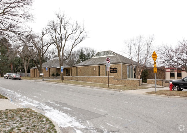
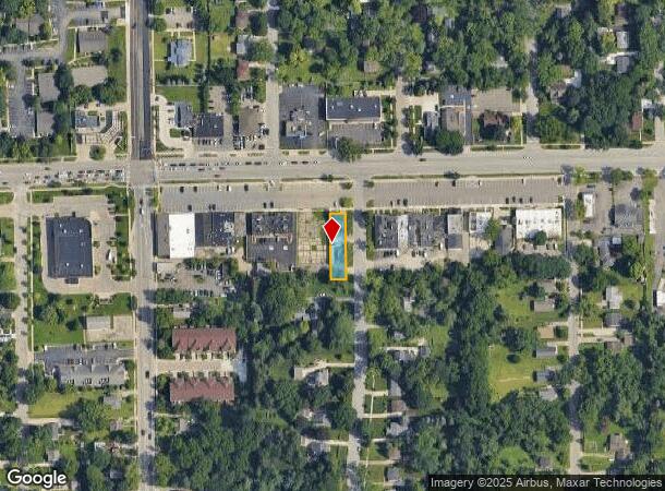
3042 Creek Dr
Ann Arbor, MI
Wagner Mccomb Blvd Gardens
12-11-208-008
E 40 FT LOT 4 WAGNER MC COMB BLVD GARDENS
Commercialnec
Washtenaw
X
Michigan
26161C0402E
4
2025
0.16 AC
2025
Washtenaw W of 23
405500
Detroit
4,150 SF
DEMOGRAPHICS near 3042 Creek Dr
1 Mile
3 Mile
5 Mile
2024 Total Population
10,155
79,789
182,613
2029 Population
10,003
78,520
180,660
Pop Growth 2024-2029
(1.50%)
(1.59%)
(1.07%)
Average Age
41
36
36
2024 Total Households
4,681
32,837
76,403
HH Growth 2024-2029
(1.67%)
(1.61%)
(1.08%)
Median Household Inc
$59,555
$65,490
$68,858
Avg Household Size
2.10
2.10
2.10
2024 Avg HH Vehicles
2.00
2.00
2.00
Median Home Value
$246,869
$326,237
$373,300
Median Year Built
1968
1976
1975
Nearby Places
Map Layers
Map Styles
 Street
 Aerial
- Restaurants
- Banks
- Shops
- Fitness
- Groceries
PUBLIC TRANSPORTATION
COMMUTER RAIL
DRIVE
WALK
Distance
10 min
4.4 mi
AIRPORT
Detroit Metro Wayne County
DRIVE
WALK
Distance
Detroit Metro Wayne County
36 min
24.1 mi
Freight Ports
DRIVE
WALK
Distance
74 min
55.9 mi
Nearby Properties
Address
Land Use
TOTAL SIZE
Lot Size
Zoning
Address
Land Use
TOTAL SIZE
Lot Size
Zoning
235,070 SF
0.80 AC
D1
Address
Land Use
TOTAL SIZE
Lot Size
Zoning
407,374 SF
35.17 AC
C3
Address
Land Use
TOTAL SIZE
Lot Size
Zoning
Address
Land Use
TOTAL SIZE
Lot Size
Zoning
211,670 SF
0.54 AC
D1
Address
Land Use
TOTAL SIZE
Lot Size
Zoning
222,126 SF
0.52 AC
D1
Address
Land Use
TOTAL SIZE
Lot Size
Zoning
2,668 SF
31.60 AC
PUD
Address
Land Use
TOTAL SIZE
Lot Size
Zoning
315,108 SF
6.57 AC
C1B
Address
Land Use
TOTAL SIZE
Lot Size
Zoning
524,946 SF
10.43 AC
PUD
Address
Land Use
TOTAL SIZE
Lot Size
Zoning
173,885 SF
0.45 AC
D1
Address
Land Use
TOTAL SIZE
Lot Size
Zoning
334,077 SF
20.41 AC
R4B
Address
Land Use
TOTAL SIZE
Lot Size
Zoning
36,000 SF
27.61 AC
BI
Address
Land Use
TOTAL SIZE
Lot Size
Zoning
357,978 SF
19.32 AC
R4B
Address
Land Use
TOTAL SIZE
Lot Size
Zoning
112,994 SF
45.12 AC
IH
Address
Land Use
TOTAL SIZE
Lot Size
Zoning
99,982 SF
0.35 AC
D1
Address
Land Use
TOTAL SIZE
Lot Size
Zoning
140,039 SF
Address
Land Use
TOTAL SIZE
Lot Size
Zoning
127,076 SF
0.39 AC
D1
Address
Land Use
TOTAL SIZE
Lot Size
Zoning
214,559 SF
16.18 AC
PUD
Address
Land Use
TOTAL SIZE
Lot Size
Zoning
37,500 SF
25.94 AC
BI
Address
Land Use
TOTAL SIZE
Lot Size
Zoning
125,073 SF
0.26 AC
D1
Address
Land Use
TOTAL SIZE
Lot Size
Zoning
1.19 AC
R4C
Address
Land Use
TOTAL SIZE
Lot Size
Zoning
17,672 SF
33.37 AC
BI
Address
Land Use
TOTAL SIZE
Lot Size
Zoning
361,634 SF
17.09 AC
Address
Land Use
TOTAL SIZE
Lot Size
Zoning
32,040 SF
22.33 AC
BI
Address
Land Use
TOTAL SIZE
Lot Size
Zoning
5,416 SF
30.14 AC
R-9
Address
Land Use
TOTAL SIZE
Lot Size
Zoning
27,603 SF
35.42 AC
BI
Address
Land Use
TOTAL SIZE
Lot Size
Zoning
111,435 SF
21.38 AC
R4B
Address
Land Use
TOTAL SIZE
Lot Size
Zoning
175,536 SF
12.98 AC
R4B
Address
Land Use
TOTAL SIZE
Lot Size
Zoning
119,631 SF
7.85 AC
PUD
Address
Land Use
TOTAL SIZE
Lot Size
Zoning
13,720 SF
37.87 AC
Address
Land Use
TOTAL SIZE
Lot Size
Zoning
192,726 SF
6.45 AC
O
The World's #1 Commercial Real Estate Marketplace
Connect with us
© 2025 CoStar Group
The information above has been obtained from sources believed reliable. While we do not doubt its accuracy we have not verified it and make no guarantee, warranty or representation about it. It is your responsibility to independently confirm its accuracy and completeness. Any projections, opinions, assumptions, or estimates used are for example only and do not represent the current or future performance of the property. The value of this transaction to you depends on tax and other factors which should be evaluated by your tax, financial, and legal advisors. You and your advisors should conduct a careful, independent investigation of the property to determine to your satisfaction the suitability of the property for your needs.