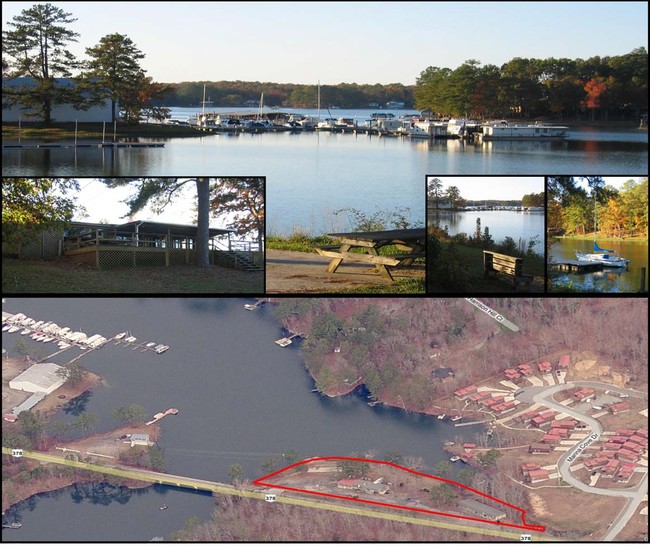
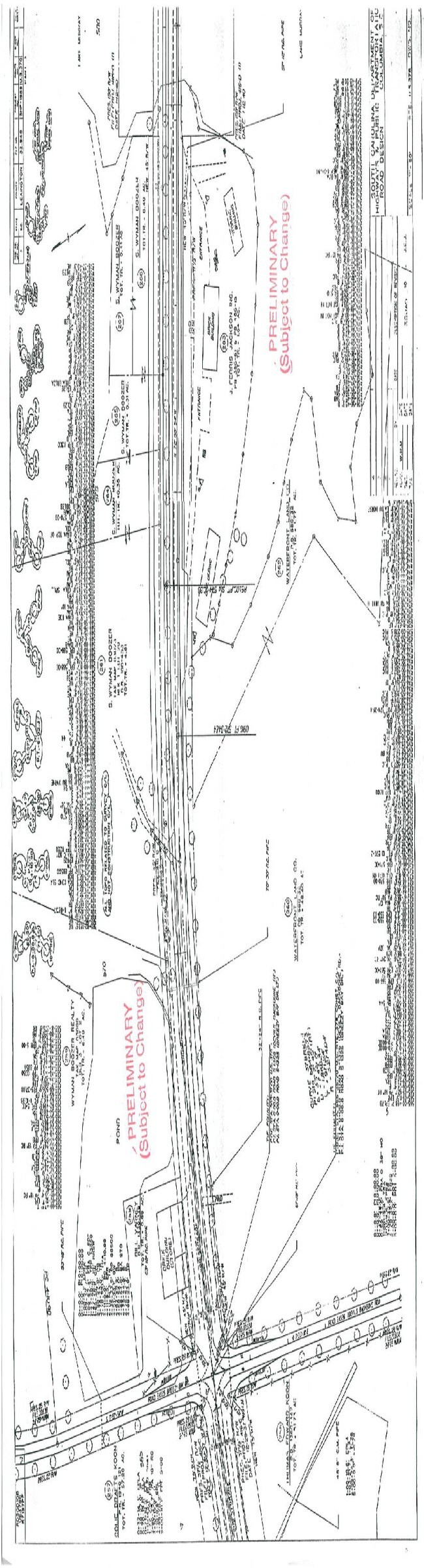
Property Record
3044 Highway 378, Leesville, SC 29070

Property Detail
3044 Highway 378
003000-02-048
LEXINGTON
Realpropertynec
South Carolina
ID
1.60 AC
AE The base floodplain where base flood elevations are provided. AE Zones are now used on new format FIRMs instead of A1-A30 Zones.
Outlying Lexington County
2025
Columbia
2024
Columbia, SC
021303
NEARBY LISTINGS FOR SALE OR LEASE
DEMOGRAPHICS near 3044 Highway 378
1 mile
3 mile
5 mile
2025 Total Population
1,070
4,893
13,255
2030 Population
1,139
5,235
14,112
Pop Growth 2025-2030
+ 6.45%
+ 6.99%
+ 6.47%
Average Age
48
48
46
2025 Total Households
466
2,083
5,428
HH Growth 2025-2030
+ 6.65%
+ 7.25%
+ 6.69%
Median Household Inc
$104,471
$107,296
$107,331
Avg Household Size
2.30
2.30
2.40
2025 Avg HH Vehicles
3.00
2.00
3.00
Median Home Value
$385,592
$437,988
$420,909
Median Year Built
1994
1997
1998
Nearby Places
Map Layers
Map Styles
 Street
 Aerial
Layers
 Traffic
 Biking
Places
Listings with unknown addresses are not visible on the map
- Restaurants
- Banks
- Shops
- Fitness
- Groceries
PUBLIC TRANSPORTATION
AIRPORT
Columbia Metro
Drive
Walk
Distance
Columbia Metro
44 min
24.1 mi
Freight Ports
North Charleston Terminal
Drive
Walk
Distance
North Charleston Terminal
146 min
122.0 mi
Nearby Properties
Address
Land Use
TOTAL SIZE
Lot Size
Zoning
Address
Land Use
TOTAL SIZE
Lot Size
Zoning
24,000 SF
4.61 AC
ID
Address
Land Use
TOTAL SIZE
Lot Size
Zoning
5,145 SF
2 AC
ID
Address
Land Use
TOTAL SIZE
Lot Size
Zoning
9,090 SF
2.15 AC
ID
Address
Land Use
TOTAL SIZE
Lot Size
Zoning
1,712 SF
4.65 AC
ID
Address
Land Use
TOTAL SIZE
Lot Size
Zoning
750 SF
1.59 AC
LR
Address
Land Use
TOTAL SIZE
Lot Size
Zoning
7,960 SF
2.71 AC
ID
Address
Land Use
TOTAL SIZE
Lot Size
Zoning
19,336 SF
1.31 AC
ID
Address
Land Use
TOTAL SIZE
Lot Size
Zoning
11,615 SF
1.11 AC
ID
Address
Land Use
TOTAL SIZE
Lot Size
Zoning
960 SF
3.17 AC
ID
Address
Land Use
TOTAL SIZE
Lot Size
Zoning
3,570 SF
0.39 AC
ID
Address
Land Use
TOTAL SIZE
Lot Size
Zoning
1,604 SF
0.32 AC
RD
Address
Land Use
TOTAL SIZE
Lot Size
Zoning
5,050 SF
0.38 AC
RD
Address
Land Use
TOTAL SIZE
Lot Size
Zoning
3,007 SF
0.38 AC
RD
Address
Land Use
TOTAL SIZE
Lot Size
Zoning
2,252 SF
3.33 AC
LR
Address
Land Use
TOTAL SIZE
Lot Size
Zoning
5,000 SF
2.37 AC
ID
Address
Land Use
TOTAL SIZE
Lot Size
Zoning
3,057 SF
0.33 AC
RD
Address
Land Use
TOTAL SIZE
Lot Size
Zoning
4,122 SF
1.35 AC
Address
Land Use
TOTAL SIZE
Lot Size
Zoning
2.78 AC
RD
Address
Land Use
TOTAL SIZE
Lot Size
Zoning
6,498 SF
32.50 AC
RD
Address
Land Use
TOTAL SIZE
Lot Size
Zoning
0.56 AC
RD
Address
Land Use
TOTAL SIZE
Lot Size
Zoning
3,000 SF
3.51 AC
ID
Address
Land Use
TOTAL SIZE
Lot Size
Zoning
3.27 AC
RD
Address
Land Use
TOTAL SIZE
Lot Size
Zoning
560 SF
RD
Address
Land Use
TOTAL SIZE
Lot Size
Zoning
1,673 SF
1.79 AC
ID
Address
Land Use
TOTAL SIZE
Lot Size
Zoning
3,094 SF
0.49 AC
RD
Address
Land Use
TOTAL SIZE
Lot Size
Zoning
0.87 AC
RD
Address
Land Use
TOTAL SIZE
Lot Size
Zoning
1,848 SF
0.74 AC
RD
Address
Land Use
TOTAL SIZE
Lot Size
Zoning
5.48 AC
LR
Address
Land Use
TOTAL SIZE
Lot Size
Zoning
0.63 AC
RD
The World's #1 Commercial Real Estate Marketplace
Connect with us
© 2026 CoStar Group
The information above has been obtained from sources believed reliable. While we do not doubt its accuracy we have not verified it and make no guarantee, warranty or representation about it. It is your responsibility to independently confirm its accuracy and completeness. Any projections, opinions, assumptions, or estimates used are for example only and do not represent the current or future performance of the property. The value of this transaction to you depends on tax and other factors which should be evaluated by your tax, financial, and legal advisors. You and your advisors should conduct a careful, independent investigation of the property to determine to your satisfaction the suitability of the property for your needs.