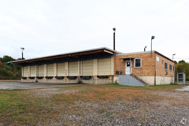
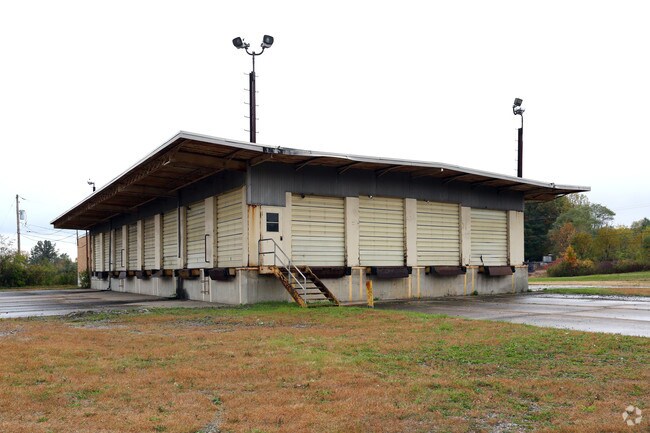
Property Record
3045 Gale Dr, Hubbard, OH 44425

Property Detail
3045 Gale Dr
Youngstown-Warren, OH
41 1 4.528A GALE DR HUBBARD TWP
01-514770
Trumbull
Distributionwarehouseregional
Ohio
B and X Area of moderate flood hazard, usually the area between the limits of the 100-year and 500-year floods.
1
2025
4.53 AC
2025
Trumbull County
931500
Youngstown/Warren/Boardman
5,850 SF
NEARBY LISTINGS FOR SALE OR LEASE
DEMOGRAPHICS near 3045 Gale Dr
1 mile
3 mile
5 mile
2025 Total Population
1,281
22,054
59,000
2030 Population
1,278
21,957
58,861
Pop Growth 2025-2030
(0.23%)
(0.44%)
(0.24%)
Average Age
44
43
42
2025 Total Households
572
9,250
24,696
HH Growth 2025-2030
(0.17%)
(0.52%)
(0.27%)
Median Household Inc
$49,166
$52,426
$42,200
Avg Household Size
2.20
2.20
2.20
2025 Avg HH Vehicles
2.00
2.00
2.00
Median Home Value
$150,246
$143,387
$119,516
Median Year Built
1965
1962
1958
Nearby Places
Map Layers
Map Styles
 Street
 Aerial
Layers
 Traffic
 Biking
Places
Listings with unknown addresses are not visible on the map
- Restaurants
- Banks
- Shops
- Fitness
- Groceries
Nearby Properties
Address
Land Use
TOTAL SIZE
Lot Size
Zoning
Address
Land Use
TOTAL SIZE
Lot Size
Zoning
402,080 SF
72.11 AC
Address
Land Use
TOTAL SIZE
Lot Size
Zoning
15,762 SF
23.14 AC
Address
Land Use
TOTAL SIZE
Lot Size
Zoning
55,398 SF
36.73 AC
Address
Land Use
TOTAL SIZE
Lot Size
Zoning
166,146 SF
22.30 AC
Address
Land Use
TOTAL SIZE
Lot Size
Zoning
9,999 SF
19.67 AC
Address
Land Use
TOTAL SIZE
Lot Size
Zoning
57,541 SF
1.50 AC
Address
Land Use
TOTAL SIZE
Lot Size
Zoning
77,280 SF
17.54 AC
Address
Land Use
TOTAL SIZE
Lot Size
Zoning
56.29 AC
Address
Land Use
TOTAL SIZE
Lot Size
Zoning
55,633 SF
8.75 AC
Address
Land Use
TOTAL SIZE
Lot Size
Zoning
53,934 SF
2.59 AC
Address
Land Use
TOTAL SIZE
Lot Size
Zoning
36,921 SF
3.47 AC
Address
Land Use
TOTAL SIZE
Lot Size
Zoning
66,738 SF
9.35 AC
Address
Land Use
TOTAL SIZE
Lot Size
Zoning
76,220 SF
12.16 AC
Address
Land Use
TOTAL SIZE
Lot Size
Zoning
72,771 SF
2.63 AC
Address
Land Use
TOTAL SIZE
Lot Size
Zoning
122,156 SF
10.77 AC
Address
Land Use
TOTAL SIZE
Lot Size
Zoning
36,544 SF
6.19 AC
Address
Land Use
TOTAL SIZE
Lot Size
Zoning
47,026 SF
5.62 AC
Address
Land Use
TOTAL SIZE
Lot Size
Zoning
9,104 SF
4.50 AC
Address
Land Use
TOTAL SIZE
Lot Size
Zoning
17,913 SF
2.23 AC
Address
Land Use
TOTAL SIZE
Lot Size
Zoning
16,608 SF
2.50 AC
Address
Land Use
TOTAL SIZE
Lot Size
Zoning
45,368 SF
4.88 AC
Address
Land Use
TOTAL SIZE
Lot Size
Zoning
17,767 SF
22.88 AC
Address
Land Use
TOTAL SIZE
Lot Size
Zoning
73,380 SF
3.74 AC
Address
Land Use
TOTAL SIZE
Lot Size
Zoning
28,979 SF
6.17 AC
Address
Land Use
TOTAL SIZE
Lot Size
Zoning
21,018 SF
4.52 AC
Address
Land Use
TOTAL SIZE
Lot Size
Zoning
9,509 SF
14.35 AC
Address
Land Use
TOTAL SIZE
Lot Size
Zoning
14,260 SF
6.72 AC
Address
Land Use
TOTAL SIZE
Lot Size
Zoning
4,200 SF
25.92 AC
Address
Land Use
TOTAL SIZE
Lot Size
Zoning
37,060 SF
3.03 AC
Address
Land Use
TOTAL SIZE
Lot Size
Zoning
5.31 AC
The World's #1 Commercial Real Estate Marketplace
Connect with us
© 2026 CoStar Group
The information above has been obtained from sources believed reliable. While we do not doubt its accuracy we have not verified it and make no guarantee, warranty or representation about it. It is your responsibility to independently confirm its accuracy and completeness. Any projections, opinions, assumptions, or estimates used are for example only and do not represent the current or future performance of the property. The value of this transaction to you depends on tax and other factors which should be evaluated by your tax, financial, and legal advisors. You and your advisors should conduct a careful, independent investigation of the property to determine to your satisfaction the suitability of the property for your needs.