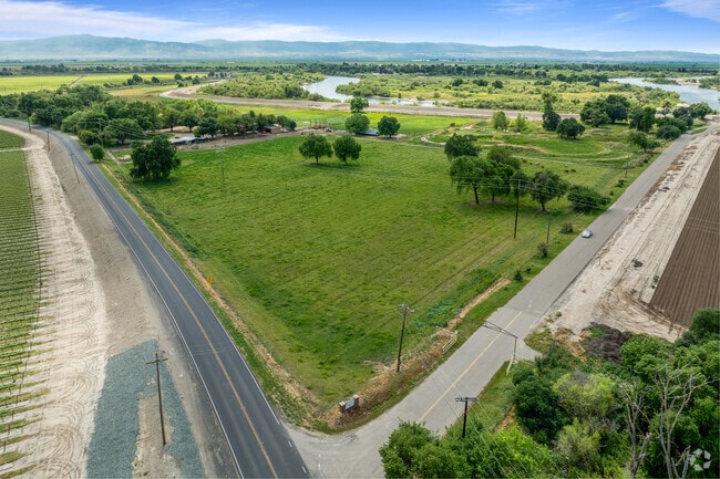
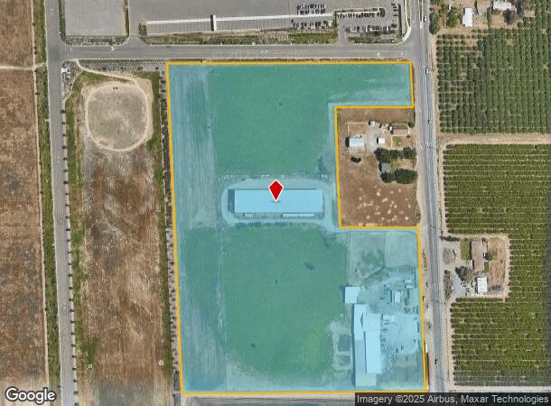
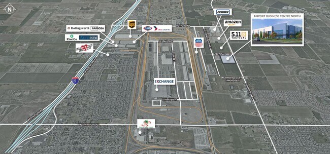
Property Record
3045 N Airport Way, Manteca, CA 95336
Current Lease Availabilities
NEARBY LISTINGS FOR SALE OR LEASE
Property Detail
3045 N Airport Way
Stockton-Lodi, CA
Airport Way Park
198-200-13
10-FM PT OF 198-020-04/198-200-08/10/PT TO 198-200
Foodprocessing
San Joaquin
X
California
06077C0610F
19.06 AC
2025
Manteca
2025
Stockton/Modesto
005135
DEMOGRAPHICS near 3045 N Airport Way
1 Mile
3 Mile
5 Mile
2024 Total Population
1,471
46,145
119,262
2029 Population
1,558
48,543
125,965
Pop Growth 2024-2029
+ 5.91%
+ 5.20%
+ 5.62%
Average Age
68
39
38
2024 Total Households
805
14,460
35,782
HH Growth 2024-2029
+ 5.96%
+ 5.24%
+ 5.74%
Median Household Inc
$84,328
$93,101
$89,999
Avg Household Size
1.80
3.10
3.20
2024 Avg HH Vehicles
2.00
3.00
2.00
Median Home Value
$600,656
$470,174
$471,208
Median Year Built
2010
1989
1992
Nearby Places
- Restaurants
- Banks
- Shops
- Fitness
- Groceries
PUBLIC TRANSPORTATION
COMMUTER RAIL
Lathrop/Manteca (ACE Train - Altamont Commuter Express (ACE), Altamont Corridor Express - Altamont Commuter Express (ACE))
DRIVE
WALK
Distance
Lathrop/Manteca (ACE Train - Altamont Commuter Express (ACE), Altamont Corridor Express - Altamont Commuter Express (ACE))
9 min
4.4 mi
Stockton (San Joaquins - Amtrak)
DRIVE
WALK
Distance
Stockton (San Joaquins - Amtrak)
14 min
9.3 mi
AIRPORT
Stockton Metro
DRIVE
WALK
Distance
Stockton Metro
8 min
3.9 mi
Freight Ports
Port of Stockton
DRIVE
WALK
Distance
Port of Stockton
17 min
11.2 mi
Nearby Properties
Address
Land Use
TOTAL SIZE
Lot Size
Zoning
Address
Land Use
TOTAL SIZE
Lot Size
Zoning
730,300 SF
41.44 AC
Address
Land Use
TOTAL SIZE
Lot Size
Zoning
832,994 SF
106.05 AC
Address
Land Use
TOTAL SIZE
Lot Size
Zoning
622,959 SF
31.75 AC
IW
Address
Land Use
TOTAL SIZE
Lot Size
Zoning
600 SF
19.12 AC
Address
Land Use
TOTAL SIZE
Lot Size
Zoning
649,693 SF
35.59 AC
Address
Land Use
TOTAL SIZE
Lot Size
Zoning
81.08 AC
Address
Land Use
TOTAL SIZE
Lot Size
Zoning
746,790 SF
39.23 AC
M2
Address
Land Use
TOTAL SIZE
Lot Size
Zoning
830,175 SF
46.57 AC
IG
Address
Land Use
TOTAL SIZE
Lot Size
Zoning
Address
Land Use
TOTAL SIZE
Lot Size
Zoning
745,640 SF
41.63 AC
Address
Land Use
TOTAL SIZE
Lot Size
Zoning
565,580 SF
56.99 AC
Address
Land Use
TOTAL SIZE
Lot Size
Zoning
16.02 AC
Address
Land Use
TOTAL SIZE
Lot Size
Zoning
374,976 SF
15.18 AC
Address
Land Use
TOTAL SIZE
Lot Size
Zoning
343,732 SF
13.90 AC
Address
Land Use
TOTAL SIZE
Lot Size
Zoning
436,800 SF
21.71 AC
Address
Land Use
TOTAL SIZE
Lot Size
Zoning
19,912 SF
6.49 AC
C1
Address
Land Use
TOTAL SIZE
Lot Size
Zoning
404,657 SF
24.89 AC
AG40
Address
Land Use
TOTAL SIZE
Lot Size
Zoning
406,580 SF
18.65 AC
Address
Land Use
TOTAL SIZE
Lot Size
Zoning
15,476 SF
7.83 AC
CO
Address
Land Use
TOTAL SIZE
Lot Size
Zoning
10.83 AC
Address
Land Use
TOTAL SIZE
Lot Size
Zoning
11.32 AC
Address
Land Use
TOTAL SIZE
Lot Size
Zoning
110,000 SF
15.10 AC
Address
Land Use
TOTAL SIZE
Lot Size
Zoning
322,560 SF
12.85 AC
Address
Land Use
TOTAL SIZE
Lot Size
Zoning
4,800 SF
32.64 AC
Address
Land Use
TOTAL SIZE
Lot Size
Zoning
7.72 AC
Address
Land Use
TOTAL SIZE
Lot Size
Zoning
Address
Land Use
TOTAL SIZE
Lot Size
Zoning
7.18 AC
Address
Land Use
TOTAL SIZE
Lot Size
Zoning
13.74 AC
Address
Land Use
TOTAL SIZE
Lot Size
Zoning
262,400 SF
11.73 AC
Address
Land Use
TOTAL SIZE
Lot Size
Zoning
145,230 SF
8.62 AC
The World's #1 Commercial Real Estate Marketplace
Connect with us
© 2025 CoStar Group
The information above has been obtained from sources believed reliable. While we do not doubt its accuracy we have not verified it and make no guarantee, warranty or representation about it. It is your responsibility to independently confirm its accuracy and completeness. Any projections, opinions, assumptions, or estimates used are for example only and do not represent the current or future performance of the property. The value of this transaction to you depends on tax and other factors which should be evaluated by your tax, financial, and legal advisors. You and your advisors should conduct a careful, independent investigation of the property to determine to your satisfaction the suitability of the property for your needs.