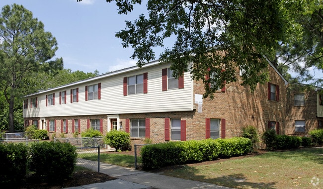
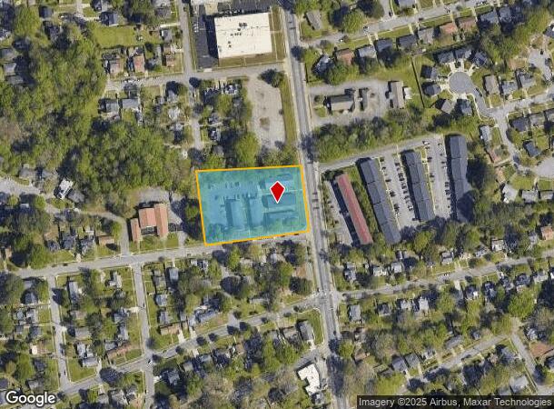
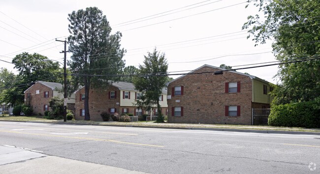
Property Record
3045 Sewells Point Rd, Norfolk, VA 23513
NEARBY LISTINGS FOR SALE OR LEASE
-
-
View all Norfolk listings for sale on LoopNet.com
Property Detail
3045 Sewells Point Rd
22014730
Property Of S A Moore
Apartment
1,2 & PT SITE B
AE
Norfolk City
5101040038H
Virginia
2025
2.01 AC
2025
Greenwood
006100
Hampton Roads
35,616 SF
Virginia Beach-Chesapeake-Norfolk, VA-NC
DEMOGRAPHICS near 3045 Sewells Point Rd
1 Mile
3 Mile
5 Mile
2024 Total Population
16,260
98,470
291,379
2029 Population
15,798
95,992
287,159
Pop Growth 2024-2029
(2.84%)
(2.52%)
(1.45%)
Average Age
38
38
38
2024 Total Households
6,416
38,941
119,191
HH Growth 2024-2029
(3.24%)
(2.99%)
(1.79%)
Median Household Inc
$60,821
$57,877
$61,685
Avg Household Size
2.40
2.40
2.30
2024 Avg HH Vehicles
2.00
2.00
2.00
Median Home Value
$187,029
$223,657
$253,255
Median Year Built
1960
1963
1969
Nearby Places
Map Layers
Map Styles
 Street
 Aerial
- Restaurants
- Banks
- Shops
- Fitness
- Groceries
PUBLIC TRANSPORTATION
COMMUTER RAIL
Norfolk (Northeast Regional - Amtrak)
DRIVE
WALK
Distance
Norfolk (Northeast Regional - Amtrak)
8 min
4.0 mi
AIRPORT
Norfolk International
DRIVE
WALK
Distance
Norfolk International
7 min
2.8 mi
Newport News/Williamsburg International
DRIVE
WALK
Distance
Newport News/Williamsburg International
41 min
27.0 mi
Freight Ports
Virginia Port Authority - Portsmouth
DRIVE
WALK
Distance
Virginia Port Authority - Portsmouth
19 min
7.9 mi
Nearby Properties
Address
Land Use
TOTAL SIZE
Lot Size
Zoning
Address
Land Use
TOTAL SIZE
Lot Size
Zoning
2,301.65 AC
Address
Land Use
TOTAL SIZE
Lot Size
Zoning
223 AC
I5
Address
Land Use
TOTAL SIZE
Lot Size
Zoning
Address
Land Use
TOTAL SIZE
Lot Size
Zoning
Address
Land Use
TOTAL SIZE
Lot Size
Zoning
116,476 SF
947.43 AC
Address
Land Use
TOTAL SIZE
Lot Size
Zoning
52.36 AC
Address
Land Use
TOTAL SIZE
Lot Size
Zoning
281,816 SF
11.72 AC
Address
Land Use
TOTAL SIZE
Lot Size
Zoning
697,880 SF
200.35 AC
R15
Address
Land Use
TOTAL SIZE
Lot Size
Zoning
30,036 SF
50.39 AC
Address
Land Use
TOTAL SIZE
Lot Size
Zoning
55.11 AC
IN2
Address
Land Use
TOTAL SIZE
Lot Size
Zoning
92.17 AC
OSP
Address
Land Use
TOTAL SIZE
Lot Size
Zoning
23.51 AC
R13
Address
Land Use
TOTAL SIZE
Lot Size
Zoning
132 SF
71.89 AC
Address
Land Use
TOTAL SIZE
Lot Size
Zoning
40.37 AC
R6
Address
Land Use
TOTAL SIZE
Lot Size
Zoning
95.32 AC
Address
Land Use
TOTAL SIZE
Lot Size
Zoning
434,920 SF
8.35 AC
A36
Address
Land Use
TOTAL SIZE
Lot Size
Zoning
321,691 SF
30.58 AC
Address
Land Use
TOTAL SIZE
Lot Size
Zoning
340,291 SF
18.77 AC
O1
Address
Land Use
TOTAL SIZE
Lot Size
Zoning
Address
Land Use
TOTAL SIZE
Lot Size
Zoning
12.85 AC
A24
Address
Land Use
TOTAL SIZE
Lot Size
Zoning
319,444 SF
19.02 AC
O1
Address
Land Use
TOTAL SIZE
Lot Size
Zoning
3,858 SF
17.85 AC
Address
Land Use
TOTAL SIZE
Lot Size
Zoning
167,279 SF
9.97 AC
IN1
Address
Land Use
TOTAL SIZE
Lot Size
Zoning
4,197 SF
56.14 AC
C2
Address
Land Use
TOTAL SIZE
Lot Size
Zoning
83,307 SF
9.78 AC
CSECPD
Address
Land Use
TOTAL SIZE
Lot Size
Zoning
1,020 SF
13.45 AC
R11
Address
Land Use
TOTAL SIZE
Lot Size
Zoning
47,832 SF
7.51 AC
C2
Address
Land Use
TOTAL SIZE
Lot Size
Zoning
19.47 AC
86
Address
Land Use
TOTAL SIZE
Lot Size
Zoning
34.54 AC
IN2
Address
Land Use
TOTAL SIZE
Lot Size
Zoning
60,821 SF
27.42 AC
IN1
The World's #1 Commercial Real Estate Marketplace
Connect with us
© 2026 CoStar Group
The information above has been obtained from sources believed reliable. While we do not doubt its accuracy we have not verified it and make no guarantee, warranty or representation about it. It is your responsibility to independently confirm its accuracy and completeness. Any projections, opinions, assumptions, or estimates used are for example only and do not represent the current or future performance of the property. The value of this transaction to you depends on tax and other factors which should be evaluated by your tax, financial, and legal advisors. You and your advisors should conduct a careful, independent investigation of the property to determine to your satisfaction the suitability of the property for your needs.