Property Record
3045 Wilkins Rd, Swanton, OH 43558
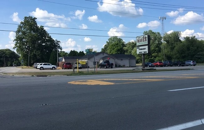

This Property Is For Sale
Property Detail
3045 Wilkins Rd
72-10301
9 7 9 NW 1/4 S 280 FT 5 AC SW PT THT PTN OF RD & EXC PT IN
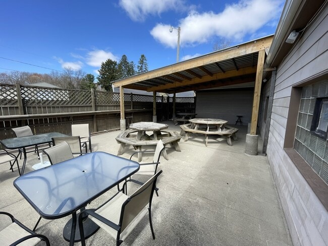
Restaurantbuilding
LUCAS
33-C2
Ohio
B and X Area of moderate flood hazard, usually the area between the limits of the 100-year and 500-year floods.
2.12 AC
0
South/Southwest
2025
Toledo
009500
Toledo, OH
2,919 SF
NEARBY LISTINGS FOR SALE OR LEASE
DEMOGRAPHICS near 3045 Wilkins Rd
1 mile
3 mile
5 mile
2025 Total Population
267
6,469
16,713
2030 Population
273
6,435
16,520
Pop Growth 2025-2030
+ 2.25%
(0.53%)
(1.15%)
Average Age
44
43
43
2025 Total Households
109
2,583
6,490
HH Growth 2025-2030
+ 1.83%
(0.50%)
(1.16%)
Median Household Inc
$79,545
$76,220
$85,072
Avg Household Size
2.40
2.50
2.50
2025 Avg HH Vehicles
3.00
2.00
2.00
Median Home Value
$162,068
$207,514
$249,651
Median Year Built
1977
1970
1975
Nearby Places
Map Layers
Map Styles
 Street
 Aerial
Layers
 Traffic
 Biking
Places
Listings with unknown addresses are not visible on the map
- Restaurants
- Banks
- Shops
- Fitness
- Groceries
PUBLIC TRANSPORTATION
AIRPORT
Eugene F Kranz Toledo Express
Drive
Walk
Distance
Eugene F Kranz Toledo Express
11 min
3.0 mi
Freight Ports
Drive
Walk
Distance
40 min
22.6 mi
Nearby Properties
Address
Land Use
TOTAL SIZE
Lot Size
Zoning
Address
Land Use
TOTAL SIZE
Lot Size
Zoning
178,278 SF
399.08 AC
33-A
Address
Land Use
TOTAL SIZE
Lot Size
Zoning
45,915 SF
49.24 AC
R1
Address
Land Use
TOTAL SIZE
Lot Size
Zoning
8,571 SF
43.96 AC
18-R1
Address
Land Use
TOTAL SIZE
Lot Size
Zoning
262.63 AC
33-MX
Address
Land Use
TOTAL SIZE
Lot Size
Zoning
131,800 SF
9.55 AC
33-M1
Address
Land Use
TOTAL SIZE
Lot Size
Zoning
21.09 AC
33-A
Address
Land Use
TOTAL SIZE
Lot Size
Zoning
77,220 SF
262.63 AC
33-MX
Address
Land Use
TOTAL SIZE
Lot Size
Zoning
323,240 SF
21.09 AC
33-A
Address
Land Use
TOTAL SIZE
Lot Size
Zoning
228.67 AC
33-MX
Address
Land Use
TOTAL SIZE
Lot Size
Zoning
3,744 SF
6.55 AC
R2
Address
Land Use
TOTAL SIZE
Lot Size
Zoning
100,000 SF
6.70 AC
33-M1
Address
Land Use
TOTAL SIZE
Lot Size
Zoning
102,232 SF
6.29 AC
33-MX
Address
Land Use
TOTAL SIZE
Lot Size
Zoning
4,971 SF
4.80 AC
R2
Address
Land Use
TOTAL SIZE
Lot Size
Zoning
68,395 SF
398.85 AC
33-A
Address
Land Use
TOTAL SIZE
Lot Size
Zoning
33,716 SF
2.76 AC
B3
Address
Land Use
TOTAL SIZE
Lot Size
Zoning
9,381 SF
414.42 AC
33-A
Address
Land Use
TOTAL SIZE
Lot Size
Zoning
26,838 SF
22.67 AC
R2
Address
Land Use
TOTAL SIZE
Lot Size
Zoning
58,438 SF
398.85 AC
33-A
Address
Land Use
TOTAL SIZE
Lot Size
Zoning
32,704 SF
1.18 AC
33-A
Address
Land Use
TOTAL SIZE
Lot Size
Zoning
23,318 SF
9.68 AC
B3
Address
Land Use
TOTAL SIZE
Lot Size
Zoning
4,800 SF
4.05 AC
B3
Address
Land Use
TOTAL SIZE
Lot Size
Zoning
21,284 SF
111.40 AC
18-B3
Address
Land Use
TOTAL SIZE
Lot Size
Zoning
39,924 SF
1.63 AC
33-A
Address
Land Use
TOTAL SIZE
Lot Size
Zoning
9,920 SF
26.76 AC
18-B3
Address
Land Use
TOTAL SIZE
Lot Size
Zoning
4,733 SF
41.71 AC
18-A
Address
Land Use
TOTAL SIZE
Lot Size
Zoning
32,883 SF
1.30 AC
33-A
Address
Land Use
TOTAL SIZE
Lot Size
Zoning
54,293 SF
4.96 AC
B3
Address
Land Use
TOTAL SIZE
Lot Size
Zoning
27,412 SF
1 AC
17-C2
Address
Land Use
TOTAL SIZE
Lot Size
Zoning
4,200 SF
10.58 AC
M2
Address
Land Use
TOTAL SIZE
Lot Size
Zoning
32,643 SF
3.42 AC
17-AR
The World's #1 Commercial Real Estate Marketplace
Connect with us
© 2026 CoStar Group
The information above has been obtained from sources believed reliable. While we do not doubt its accuracy we have not verified it and make no guarantee, warranty or representation about it. It is your responsibility to independently confirm its accuracy and completeness. Any projections, opinions, assumptions, or estimates used are for example only and do not represent the current or future performance of the property. The value of this transaction to you depends on tax and other factors which should be evaluated by your tax, financial, and legal advisors. You and your advisors should conduct a careful, independent investigation of the property to determine to your satisfaction the suitability of the property for your needs.