Property Record
3039 Bartold Ave, Saint Louis, MO 63143
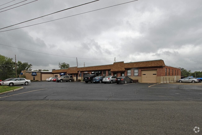

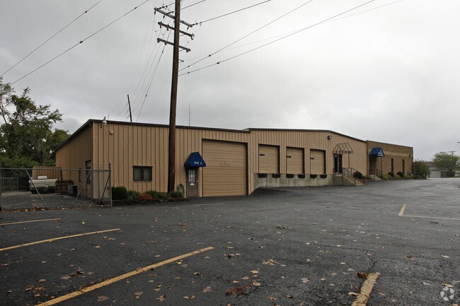
Property Detail
3039 Bartold Ave
22J-43-0963
HYATTS LOTS 4-13 LOT PTS 14-15 C S RANNELLS LOT PT 28 L BOMPART EST LOT PT 1 BDY ADJ (AKA S OUTH HANLEY BUSINESS CENTER) LOT 3
Officebuilding
ST. LOUIS
35LM
Missouri
B and X Area of moderate flood hazard, usually the area between the limits of the 100-year and 500-year floods.
3
2024
0.66 AC
2025
Hanley
216900
St. Louis
10,170 SF
St. Louis, MO-IL
NEARBY LISTINGS FOR SALE OR LEASE
DEMOGRAPHICS near 3039 Bartold Ave
1 mile
3 mile
5 mile
2025 Total Population
11,812
116,890
321,009
2030 Population
11,765
113,502
311,397
Pop Growth 2025-2030
(0.40%)
(2.90%)
(2.99%)
Average Age
39
40
41
2025 Total Households
5,469
53,030
146,992
HH Growth 2025-2030
(0.26%)
(3.37%)
(3.44%)
Median Household Inc
$83,258
$95,102
$86,831
Avg Household Size
2.10
2.10
2.10
2025 Avg HH Vehicles
2.00
2.00
2.00
Median Home Value
$302,285
$323,005
$299,411
Median Year Built
1948
1951
1951
Nearby Places
Map Layers
Map Styles
 Street
 Aerial
Transit
 Traffic
 Biking
Places
Listings with unknown addresses are not visible on the map
- Restaurants
- Banks
- Shops
- Fitness
- Groceries
PUBLIC TRANSPORTATION
COMMUTER RAIL
Sunnen (Shrewsbury-Lansdowne I-44 Emerson Park - St. Louis MetroLink (MetroLink))
Drive
Walk
Distance
Sunnen (Shrewsbury-Lansdowne I-44 Emerson Park - St. Louis MetroLink (MetroLink))
1 min
6 min
0.2 mi
Maplewood-Manchester (Shrewsbury-Lansdowne I-44 Emerson Park - St. Louis MetroLink (MetroLink))
Drive
Walk
Distance
Maplewood-Manchester (Shrewsbury-Lansdowne I-44 Emerson Park - St. Louis MetroLink (MetroLink))
2 min
12 min
0.6 mi
AIRPORT
St Louis Lambert International
Drive
Walk
Distance
St Louis Lambert International
19 min
12.3 mi
Scott AFB/Midamerica St Louis
Drive
Walk
Distance
Scott AFB/Midamerica St Louis
52 min
34.8 mi
SALE & LEASE HISTORY
LISTING DATE
SALE/LEASE

Jul 06, 2017
For Lease
Aug 22, 2025
For Lease
Apr 21, 2025
For Lease
Nearby Properties
Address
Land Use
TOTAL SIZE
Lot Size
Zoning
Address
Land Use
TOTAL SIZE
Lot Size
Zoning
558,158 SF
45.66 AC
14R-2
Address
Land Use
TOTAL SIZE
Lot Size
Zoning
833,982 SF
18.70 AC
GB
Address
Land Use
TOTAL SIZE
Lot Size
Zoning
52,556 SF
68.80 AC
14R-2
Address
Land Use
TOTAL SIZE
Lot Size
Zoning
516,414 SF
2.61 AC
14C-2
Address
Land Use
TOTAL SIZE
Lot Size
Zoning
361,357 SF
2.99 AC
14HDC
Address
Land Use
TOTAL SIZE
Lot Size
Zoning
238,035 SF
3.23 AC
14HDC
Address
Land Use
TOTAL SIZE
Lot Size
Zoning
501,837 SF
21.52 AC
14PUD
Address
Land Use
TOTAL SIZE
Lot Size
Zoning
361,605 SF
1.75 AC
14HDC
Address
Land Use
TOTAL SIZE
Lot Size
Zoning
385,676 SF
3.04 AC
C4
Address
Land Use
TOTAL SIZE
Lot Size
Zoning
7,780 SF
15.61 AC
14R-2
Address
Land Use
TOTAL SIZE
Lot Size
Zoning
354,868 SF
2.04 AC
14HDC
Address
Land Use
TOTAL SIZE
Lot Size
Zoning
311,264 SF
1.40 AC
14HDC
Address
Land Use
TOTAL SIZE
Lot Size
Zoning
476,403 SF
1.40 AC
14HDC
Address
Land Use
TOTAL SIZE
Lot Size
Zoning
277,568 SF
0.68 AC
14HDC
Address
Land Use
TOTAL SIZE
Lot Size
Zoning
330,896 SF
2.68 AC
14HDC
Address
Land Use
TOTAL SIZE
Lot Size
Zoning
844,350 SF
63.08 AC
64A1
Address
Land Use
TOTAL SIZE
Lot Size
Zoning
57.77 AC
A
Address
Land Use
TOTAL SIZE
Lot Size
Zoning
316,517 SF
3.28 AC
14C-1
Address
Land Use
TOTAL SIZE
Lot Size
Zoning
183,908 SF
1.08 AC
14HDC
Address
Land Use
TOTAL SIZE
Lot Size
Zoning
17,239 SF
51.14 AC
R2
Address
Land Use
TOTAL SIZE
Lot Size
Zoning
281,259 SF
0.50 AC
14HDC
Address
Land Use
TOTAL SIZE
Lot Size
Zoning
235,785 SF
1.95 AC
C4
Address
Land Use
TOTAL SIZE
Lot Size
Zoning
178,963 SF
14.98 AC
E
Address
Land Use
TOTAL SIZE
Lot Size
Zoning
479,457 SF
1.20 AC
14SDD
Address
Land Use
TOTAL SIZE
Lot Size
Zoning
559,752 SF
24.37 AC
53R-3
Address
Land Use
TOTAL SIZE
Lot Size
Zoning
172,165 SF
1.32 AC
14HDC
Address
Land Use
TOTAL SIZE
Lot Size
Zoning
280,959 SF
3.88 AC
Address
Land Use
TOTAL SIZE
Lot Size
Zoning
322,742 SF
15.04 AC
9LID
Address
Land Use
TOTAL SIZE
Lot Size
Zoning
43,120 SF
0.70 AC
CZ
Address
Land Use
TOTAL SIZE
Lot Size
Zoning
200,936 SF
1.16 AC
14HDC
The World's #1 Commercial Real Estate Marketplace
Connect with us
© 2026 CoStar Group
The information above has been obtained from sources believed reliable. While we do not doubt its accuracy we have not verified it and make no guarantee, warranty or representation about it. It is your responsibility to independently confirm its accuracy and completeness. Any projections, opinions, assumptions, or estimates used are for example only and do not represent the current or future performance of the property. The value of this transaction to you depends on tax and other factors which should be evaluated by your tax, financial, and legal advisors. You and your advisors should conduct a careful, independent investigation of the property to determine to your satisfaction the suitability of the property for your needs.