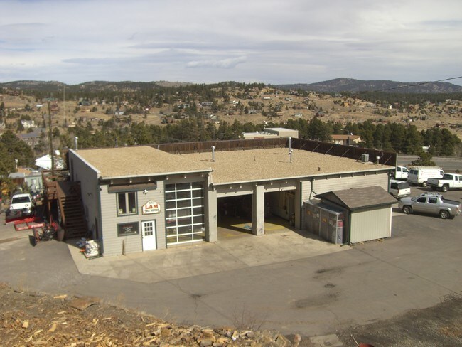
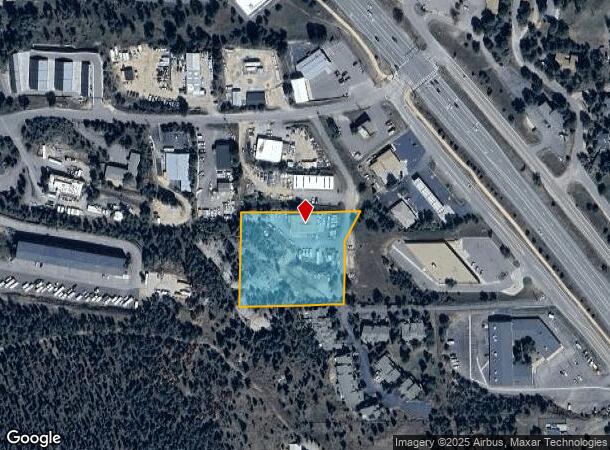
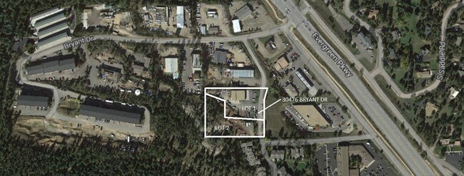
Property Record
30476 Bryant Dr, Evergreen, CO 80439

NEARBY LISTINGS FOR SALE OR LEASE
Property Detail
30476 Bryant Dr
Denver-Aurora-Centennial, CO
Evergreen Service Center
51-042-06-005
SECTION 04 TOWNSHIP 05 RANGE 71 QTR NW SUBDIVISIONCD 234300 SUBDIVISIONNAME EVERGREEN SERVICE CENTER BLOCK LOT 0001 SIZE: 46174 TRACT VALUE: 1.060 SECTION 04 TOWNSHIP 05 RANGE 71 QTR NW SUBDIVISIONCD 234300 SUBDIVISIONNAME EVERGREEN SERVICE CENTER BL
Industrialgeneral
Jefferson
X
Colorado
08059C0263F
1,2,
2023
2.12 AC
2024
Southwest Outlying
009848
Denver
4,071 SF
DEMOGRAPHICS near 30476 Bryant Dr
1 mile
3 mile
5 mile
2024 Total Population
3,375
12,225
23,401
2029 Population
3,327
12,038
23,092
Pop Growth 2024-2029
(1.42%)
(1.53%)
(1.32%)
Average Age
46
45
46
2024 Total Households
1,386
4,889
9,486
HH Growth 2024-2029
(1.59%)
(1.68%)
(1.41%)
Median Household Inc
$134,909
$137,727
$140,611
Avg Household Size
2.40
2.40
2.40
2024 Avg HH Vehicles
2.00
2.00
2.00
Median Home Value
$753,521
$798,755
$817,596
Median Year Built
1982
1979
1981
Nearby Places
Map Layers
Map Styles
 Street
 Aerial
Transit
 Traffic
 Biking
Places
Listings with unknown addresses are not visible on the map
- Restaurants
- Banks
- Shops
- Fitness
- Groceries
SALE & LEASE HISTORY
LISTING DATE
SALE/LEASE

Sep 24, 2016
For Sale
Feb 03, 2022
For Sale
Nearby Properties
Address
Land Use
TOTAL SIZE
Lot Size
Zoning
Address
Land Use
TOTAL SIZE
Lot Size
Zoning
681.88 AC
CO
Address
Land Use
TOTAL SIZE
Lot Size
Zoning
134,644 SF
51.80 AC
A2
Address
Land Use
TOTAL SIZE
Lot Size
Zoning
73,516 SF
7.55 AC
C1
Address
Land Use
TOTAL SIZE
Lot Size
Zoning
54,443 SF
4.16 AC
PD
Address
Land Use
TOTAL SIZE
Lot Size
Zoning
41,505 SF
30.15 AC
Address
Land Use
TOTAL SIZE
Lot Size
Zoning
44,100 SF
4.86 AC
PD
Address
Land Use
TOTAL SIZE
Lot Size
Zoning
89,485 SF
20.01 AC
A2
Address
Land Use
TOTAL SIZE
Lot Size
Zoning
360 AC
CO
Address
Land Use
TOTAL SIZE
Lot Size
Zoning
360 AC
A2
Address
Land Use
TOTAL SIZE
Lot Size
Zoning
116.70 AC
CO
Address
Land Use
TOTAL SIZE
Lot Size
Zoning
17,554 SF
25.57 AC
A2
Address
Land Use
TOTAL SIZE
Lot Size
Zoning
400 SF
427.06 AC
CO
Address
Land Use
TOTAL SIZE
Lot Size
Zoning
39,303 SF
3.17 AC
PD
Address
Land Use
TOTAL SIZE
Lot Size
Zoning
47,190 SF
5.22 AC
A1
Address
Land Use
TOTAL SIZE
Lot Size
Zoning
43,212 SF
169.48 AC
PD
Address
Land Use
TOTAL SIZE
Lot Size
Zoning
53,371 SF
3.69 AC
C1
Address
Land Use
TOTAL SIZE
Lot Size
Zoning
59,012 SF
2.40 AC
PD
Address
Land Use
TOTAL SIZE
Lot Size
Zoning
260.80 AC
CO
Address
Land Use
TOTAL SIZE
Lot Size
Zoning
34,581 SF
1.98 AC
PD
Address
Land Use
TOTAL SIZE
Lot Size
Zoning
51,104 SF
5.57 AC
PD
Address
Land Use
TOTAL SIZE
Lot Size
Zoning
53,106 SF
3.19 AC
C1
Address
Land Use
TOTAL SIZE
Lot Size
Zoning
37,332 SF
5.06 AC
PD
Address
Land Use
TOTAL SIZE
Lot Size
Zoning
5,298 SF
147.29 AC
CO
Address
Land Use
TOTAL SIZE
Lot Size
Zoning
70.88 AC
A2
Address
Land Use
TOTAL SIZE
Lot Size
Zoning
999.86 AC
Address
Land Use
TOTAL SIZE
Lot Size
Zoning
256.19 AC
CO
Address
Land Use
TOTAL SIZE
Lot Size
Zoning
25,104 SF
1.47 AC
PD
Address
Land Use
TOTAL SIZE
Lot Size
Zoning
50,544 SF
12.96 AC
A1
Address
Land Use
TOTAL SIZE
Lot Size
Zoning
23,124 SF
5 AC
A2
Address
Land Use
TOTAL SIZE
Lot Size
Zoning
21,685 SF
2.39 AC
PD
The World's #1 Commercial Real Estate Marketplace
Connect with us
© 2026 CoStar Group
The information above has been obtained from sources believed reliable. While we do not doubt its accuracy we have not verified it and make no guarantee, warranty or representation about it. It is your responsibility to independently confirm its accuracy and completeness. Any projections, opinions, assumptions, or estimates used are for example only and do not represent the current or future performance of the property. The value of this transaction to you depends on tax and other factors which should be evaluated by your tax, financial, and legal advisors. You and your advisors should conduct a careful, independent investigation of the property to determine to your satisfaction the suitability of the property for your needs.