Property Record
305 1St St, Benicia, CA 94510


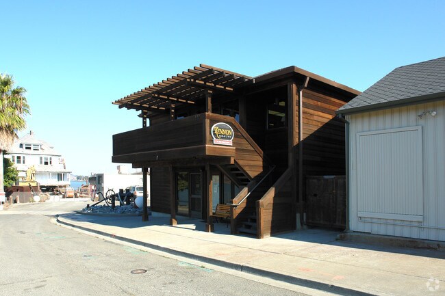
Property Detail
305 1St St
Vallejo, CA
BK-BG 00-00
0089-243-140
Solano
Commercialnec
California
VE and V1-30 Coastal areas with a 1% or greater chance of flooding and an additional hazard associated with storm waves. These areas have a 26% chance of flooding over the life of a 30-year mortgage.
12
2024
1.18 AC
2025
Benicia/Vallejo
252000
North Bay/Santa Rosa
2,672 SF
NEARBY LISTINGS FOR SALE OR LEASE
DEMOGRAPHICS near 305 1St St
1 mile
3 mile
5 mile
2025 Total Population
6,858
33,350
93,853
2030 Population
6,914
33,549
94,464
Pop Growth 2025-2030
+ 0.82%
+ 0.60%
+ 0.65%
Average Age
46
45
43
2025 Total Households
3,164
13,706
35,986
HH Growth 2025-2030
+ 0.82%
+ 0.67%
+ 0.73%
Median Household Inc
$113,787
$124,121
$116,803
Avg Household Size
2.10
2.40
2.50
2025 Avg HH Vehicles
2.00
2.00
2.00
Median Home Value
$713,034
$766,107
$731,472
Median Year Built
1973
1977
1977
Nearby Places
Map Layers
Map Styles
 Street
 Aerial
Layers
 Traffic
 Biking
Places
Listings with unknown addresses are not visible on the map
- Restaurants
- Banks
- Shops
- Fitness
- Groceries
PUBLIC TRANSPORTATION
COMMUTER RAIL
Drive
Walk
Distance
10 min
6.2 mi
AIRPORT
Metro Oakland International
Drive
Walk
Distance
Metro Oakland International
50 min
37.6 mi
San Francisco International
Drive
Walk
Distance
San Francisco International
65 min
47.3 mi
Freight Ports
Port of Richmond
Drive
Walk
Distance
Port of Richmond
38 min
25.4 mi
Nearby Properties
Address
Land Use
TOTAL SIZE
Lot Size
Zoning
Address
Land Use
TOTAL SIZE
Lot Size
Zoning
324.69 AC
Address
Land Use
TOTAL SIZE
Lot Size
Zoning
187,998 SF
135.96 AC
Address
Land Use
TOTAL SIZE
Lot Size
Zoning
15.34 AC
Address
Land Use
TOTAL SIZE
Lot Size
Zoning
66.32 AC
Address
Land Use
TOTAL SIZE
Lot Size
Zoning
68.97 AC
Address
Land Use
TOTAL SIZE
Lot Size
Zoning
7.08 AC
Address
Land Use
TOTAL SIZE
Lot Size
Zoning
49,519 SF
2.04 AC
Address
Land Use
TOTAL SIZE
Lot Size
Zoning
71,000 SF
1.23 AC
Address
Land Use
TOTAL SIZE
Lot Size
Zoning
19.90 AC
Address
Land Use
TOTAL SIZE
Lot Size
Zoning
160,000 SF
13.67 AC
Address
Land Use
TOTAL SIZE
Lot Size
Zoning
200,888 SF
19.11 AC
MR25
Address
Land Use
TOTAL SIZE
Lot Size
Zoning
22,176 SF
15.14 AC
Address
Land Use
TOTAL SIZE
Lot Size
Zoning
54,874 SF
0.57 AC
Address
Land Use
TOTAL SIZE
Lot Size
Zoning
243,000 SF
12.62 AC
Address
Land Use
TOTAL SIZE
Lot Size
Zoning
86,222 SF
39.83 AC
Address
Land Use
TOTAL SIZE
Lot Size
Zoning
12.63 AC
Address
Land Use
TOTAL SIZE
Lot Size
Zoning
19.08 AC
Address
Land Use
TOTAL SIZE
Lot Size
Zoning
13.63 AC
Address
Land Use
TOTAL SIZE
Lot Size
Zoning
488,220 SF
11.88 AC
Address
Land Use
TOTAL SIZE
Lot Size
Zoning
240,000 SF
11.77 AC
Address
Land Use
TOTAL SIZE
Lot Size
Zoning
12.80 AC
Address
Land Use
TOTAL SIZE
Lot Size
Zoning
5,259 SF
95.68 AC
Address
Land Use
TOTAL SIZE
Lot Size
Zoning
115,292 SF
9.85 AC
Address
Land Use
TOTAL SIZE
Lot Size
Zoning
61,512 SF
1.03 AC
Address
Land Use
TOTAL SIZE
Lot Size
Zoning
35,640 SF
0.92 AC
Address
Land Use
TOTAL SIZE
Lot Size
Zoning
120,000 SF
5.52 AC
Address
Land Use
TOTAL SIZE
Lot Size
Zoning
0.71 AC
Address
Land Use
TOTAL SIZE
Lot Size
Zoning
15,032 SF
47.47 AC
Address
Land Use
TOTAL SIZE
Lot Size
Zoning
77,841 SF
7.67 AC
Address
Land Use
TOTAL SIZE
Lot Size
Zoning
3.75 AC
RM
The World's #1 Commercial Real Estate Marketplace
Connect with us
© 2026 CoStar Group
The information above has been obtained from sources believed reliable. While we do not doubt its accuracy we have not verified it and make no guarantee, warranty or representation about it. It is your responsibility to independently confirm its accuracy and completeness. Any projections, opinions, assumptions, or estimates used are for example only and do not represent the current or future performance of the property. The value of this transaction to you depends on tax and other factors which should be evaluated by your tax, financial, and legal advisors. You and your advisors should conduct a careful, independent investigation of the property to determine to your satisfaction the suitability of the property for your needs.