Property Record
305 Duncan Rd, Punta Gorda, FL 33982

Save to a Folder
{{folder.Name}}
{{folder.ListingIds.length}} Properties
{{folder.ListingIds.length}} Property
Create a New Folder
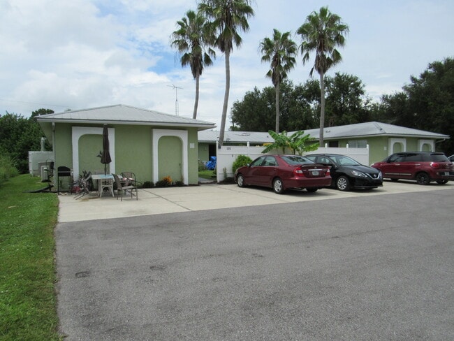
Property Detail
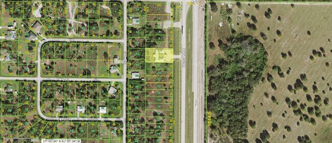
305 Duncan Rd
402301431020
PEACE RIVER SH UN 7 BLK A LTS 7 & 8 356/304 556/859 571/1767 846/1500 1423/09 AG/D1796/1454-ALLARD 1796/1455 1842/966 4772/1315 3211910 3211911 3284941
Multifamilydwelling
Charlotte
CG
Florida
B and X Area of moderate flood hazard, usually the area between the limits of the 100-year and 500-year floods.
7,8
2024
0.46 AC
2025
Outlying Punta Gorda
010200
Southwest Florida
3,170 SF
Punta Gorda, FL
NEARBY LISTINGS FOR SALE OR LEASE
-
-
View all Punta Gorda listings for sale on LoopNet.com
DEMOGRAPHICS near 305 Duncan Rd
1 mile
3 mile
5 mile
2025 Total Population
1,600
5,631
26,818
2030 Population
1,797
6,274
29,657
Pop Growth 2025-2030
+ 12.31%
+ 11.42%
+ 10.59%
Average Age
53
51
50
2025 Total Households
751
2,478
11,862
HH Growth 2025-2030
+ 12.78%
+ 11.78%
+ 10.66%
Median Household Inc
$56,989
$67,381
$65,575
Avg Household Size
2.10
2.20
2.20
2025 Avg HH Vehicles
2.00
2.00
2.00
Median Home Value
$231,250
$319,734
$345,406
Median Year Built
1992
1997
1995
Nearby Places
Map Layers
Map Styles
 Street
 Aerial
Layers
 Traffic
 Biking
Places
Listings with unknown addresses are not visible on the map
- Restaurants
- Banks
- Shops
- Fitness
- Groceries
PUBLIC TRANSPORTATION
AIRPORT
Punta Gorda
Drive
Walk
Distance
Punta Gorda
16 min
10.2 mi
SALE & LEASE HISTORY
LISTING DATE
SALE/LEASE

Sep 12, 2022
For Sale
Nearby Properties
Address
Land Use
TOTAL SIZE
Lot Size
Zoning
Address
Land Use
TOTAL SIZE
Lot Size
Zoning
1,225,024 SF
170.84 AC
IL
Address
Land Use
TOTAL SIZE
Lot Size
Zoning
2,148 SF
121.95 AC
PD
Address
Land Use
TOTAL SIZE
Lot Size
Zoning
15,866 SF
63.03 AC
TTRVC
Address
Land Use
TOTAL SIZE
Lot Size
Zoning
2,025 SF
28.05 AC
RVC
Address
Land Use
TOTAL SIZE
Lot Size
Zoning
432 SF
20 AC
A-5
Address
Land Use
TOTAL SIZE
Lot Size
Zoning
501.85 AC
A-5
Address
Land Use
TOTAL SIZE
Lot Size
Zoning
8,823 SF
73.60 AC
RE1
Address
Land Use
TOTAL SIZE
Lot Size
Zoning
8,838 SF
2.43 AC
RMF-6
Address
Land Use
TOTAL SIZE
Lot Size
Zoning
7,050 SF
4.49 AC
RSF-3
Address
Land Use
TOTAL SIZE
Lot Size
Zoning
6,109 SF
2 AC
RE1
Address
Land Use
TOTAL SIZE
Lot Size
Zoning
9,219 SF
1.15 AC
CG
Address
Land Use
TOTAL SIZE
Lot Size
Zoning
14.03 AC
CG
Address
Land Use
TOTAL SIZE
Lot Size
Zoning
72.19 AC
ROI
Address
Land Use
TOTAL SIZE
Lot Size
Zoning
139.33 AC
ES
Address
Land Use
TOTAL SIZE
Lot Size
Zoning
2,792 SF
9.60 AC
AG
Address
Land Use
TOTAL SIZE
Lot Size
Zoning
7,079 SF
2.27 AC
RMF5
Address
Land Use
TOTAL SIZE
Lot Size
Zoning
3,462 SF
1.83 AC
IL
Address
Land Use
TOTAL SIZE
Lot Size
Zoning
6.84 AC
CG
Address
Land Use
TOTAL SIZE
Lot Size
Zoning
117.80 AC
AG
Address
Land Use
TOTAL SIZE
Lot Size
Zoning
672 SF
33.58 AC
RE1
Address
Land Use
TOTAL SIZE
Lot Size
Zoning
2,577 SF
0.75 AC
RSF-2
Address
Land Use
TOTAL SIZE
Lot Size
Zoning
43.84 AC
RMF-6
Address
Land Use
TOTAL SIZE
Lot Size
Zoning
3,860 SF
5.86 AC
RE1
Address
Land Use
TOTAL SIZE
Lot Size
Zoning
7,838 SF
188.54 AC
AG
Address
Land Use
TOTAL SIZE
Lot Size
Zoning
7,511 SF
28.66 AC
AG
Address
Land Use
TOTAL SIZE
Lot Size
Zoning
3,558 SF
10.39 AC
A-10
Address
Land Use
TOTAL SIZE
Lot Size
Zoning
2,006 SF
10.01 AC
A-10
Address
Land Use
TOTAL SIZE
Lot Size
Zoning
1,629 SF
0.55 AC
AG
Address
Land Use
TOTAL SIZE
Lot Size
Zoning
12.55 AC
RSF3.5
The World's #1 Commercial Real Estate Marketplace
Connect with us
© 2026 CoStar Group
The information above has been obtained from sources believed reliable. While we do not doubt its accuracy we have not verified it and make no guarantee, warranty or representation about it. It is your responsibility to independently confirm its accuracy and completeness. Any projections, opinions, assumptions, or estimates used are for example only and do not represent the current or future performance of the property. The value of this transaction to you depends on tax and other factors which should be evaluated by your tax, financial, and legal advisors. You and your advisors should conduct a careful, independent investigation of the property to determine to your satisfaction the suitability of the property for your needs.