Property Record
305 E 10Th St, West Point, GA 31833


Save to a Folder
{{folder.Name}}
{{folder.ListingIds.length}} Properties
{{folder.ListingIds.length}} Property
Create a New Folder
Property Detail
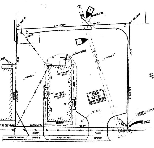
305 E 10Th St
0943D008006
305 E 10TH ST/ LTS 8&9 & PT OF 10
Restaurantbuilding
Troup
17-CGN
Georgia
AE The base floodplain where base flood elevations are provided. AE Zones are now used on new format FIRMs instead of A1-A30 Zones.
10
2025
0.42 AC
2025
Troup County
961000
Columbus GA
2,218 SF
LaGrange, GA-AL
NEARBY LISTINGS FOR SALE OR LEASE
DEMOGRAPHICS near 305 E 10Th St
1 mile
3 mile
5 mile
2025 Total Population
3,954
13,632
21,091
2030 Population
4,111
13,693
21,061
Pop Growth 2025-2030
+ 3.97%
+ 0.45%
(0.14%)
Average Age
41
41
41
2025 Total Households
1,558
5,394
8,477
HH Growth 2025-2030
+ 4.17%
+ 0.50%
(0.13%)
Median Household Inc
$46,591
$47,033
$51,474
Avg Household Size
2.50
2.40
2.40
2025 Avg HH Vehicles
2.00
2.00
2.00
Median Home Value
$155,392
$134,379
$136,511
Median Year Built
1977
1971
1974
Nearby Places
Map Layers
Map Styles
 Street
 Aerial
Layers
 Traffic
 Biking
Places
Listings with unknown addresses are not visible on the map
- Restaurants
- Banks
- Shops
- Fitness
- Groceries
PUBLIC TRANSPORTATION
AIRPORT
Columbus
Drive
Walk
Distance
Columbus
45 min
34.3 mi
SALE & LEASE HISTORY
LISTING DATE
SALE/LEASE

Jul 14, 2020
For Sale
Nearby Properties
Address
Land Use
TOTAL SIZE
Lot Size
Zoning
Address
Land Use
TOTAL SIZE
Lot Size
Zoning
39,034.56 AC
01-LR
Address
Land Use
TOTAL SIZE
Lot Size
Zoning
142,270 SF
2 AC
Address
Land Use
TOTAL SIZE
Lot Size
Zoning
17,098 SF
17.64 AC
17-SPLIT
Address
Land Use
TOTAL SIZE
Lot Size
Zoning
28,850 SF
6.63 AC
17-MXD-1
Address
Land Use
TOTAL SIZE
Lot Size
Zoning
6,800 SF
10 AC
17-I-1
Address
Land Use
TOTAL SIZE
Lot Size
Zoning
42,369 SF
1.49 AC
17-I-1
Address
Land Use
TOTAL SIZE
Lot Size
Zoning
523.41 AC
17-MXD-1
Address
Land Use
TOTAL SIZE
Lot Size
Zoning
31,290 SF
0.75 AC
17-CGN
Address
Land Use
TOTAL SIZE
Lot Size
Zoning
185.02 AC
17-R/P
Address
Land Use
TOTAL SIZE
Lot Size
Zoning
19,493 SF
15 AC
17-R-1
Address
Land Use
TOTAL SIZE
Lot Size
Zoning
106,133 SF
8.37 AC
17-I-1
Address
Land Use
TOTAL SIZE
Lot Size
Zoning
113,361 SF
8.31 AC
Address
Land Use
TOTAL SIZE
Lot Size
Zoning
7,326 SF
4.50 AC
17-I-1
Address
Land Use
TOTAL SIZE
Lot Size
Zoning
20,409 SF
2.46 AC
17-R-1
Address
Land Use
TOTAL SIZE
Lot Size
Zoning
36,225 SF
5.74 AC
17-I-1
Address
Land Use
TOTAL SIZE
Lot Size
Zoning
18,960 SF
0.36 AC
17-CBD
Address
Land Use
TOTAL SIZE
Lot Size
Zoning
60,534 SF
5.94 AC
Address
Land Use
TOTAL SIZE
Lot Size
Zoning
34,584 SF
3.68 AC
17-I-1
Address
Land Use
TOTAL SIZE
Lot Size
Zoning
17,852 SF
1.26 AC
17-CBD
Address
Land Use
TOTAL SIZE
Lot Size
Zoning
2,145 SF
8.59 AC
17-MXD-1
Address
Land Use
TOTAL SIZE
Lot Size
Zoning
57,000 SF
17.44 AC
17-I-1
Address
Land Use
TOTAL SIZE
Lot Size
Zoning
23,487 SF
2 AC
17-I-1
Address
Land Use
TOTAL SIZE
Lot Size
Zoning
10,794 SF
1.35 AC
17-CBD
Address
Land Use
TOTAL SIZE
Lot Size
Zoning
66,874 SF
3.84 AC
Address
Land Use
TOTAL SIZE
Lot Size
Zoning
Address
Land Use
TOTAL SIZE
Lot Size
Zoning
14,075 SF
0.41 AC
17-I-1
Address
Land Use
TOTAL SIZE
Lot Size
Zoning
7,200 SF
9.90 AC
17-R-1
Address
Land Use
TOTAL SIZE
Lot Size
Zoning
31,680 SF
0.28 AC
17-CBD
Address
Land Use
TOTAL SIZE
Lot Size
Zoning
51,408 SF
0.72 AC
17-CGN
Address
Land Use
TOTAL SIZE
Lot Size
Zoning
40,992 SF
6.80 AC
17-CGN
The World's #1 Commercial Real Estate Marketplace
Connect with us
© 2026 CoStar Group
The information above has been obtained from sources believed reliable. While we do not doubt its accuracy we have not verified it and make no guarantee, warranty or representation about it. It is your responsibility to independently confirm its accuracy and completeness. Any projections, opinions, assumptions, or estimates used are for example only and do not represent the current or future performance of the property. The value of this transaction to you depends on tax and other factors which should be evaluated by your tax, financial, and legal advisors. You and your advisors should conduct a careful, independent investigation of the property to determine to your satisfaction the suitability of the property for your needs.