Property Record
305 E Main St, Mansfield, OH 44904


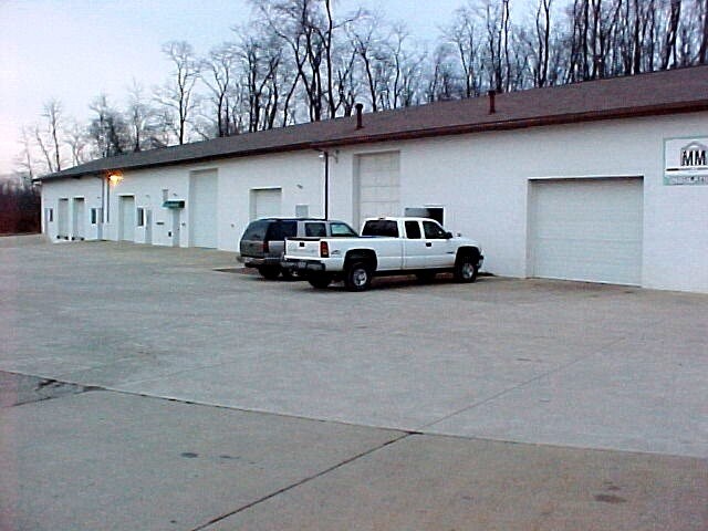
Property Detail
305 E Main St
Mansfield, OH
NE A 5.40 LT 2 PT SUBJ HWY EASE
048-27-172-16-000
Richland
Stripcommercialcenter
Ohio
B and X Area of moderate flood hazard, usually the area between the limits of the 100-year and 500-year floods.
2
2024
5.40 AC
2025
Richland County
002200
Cleveland
17,331 SF
NEARBY LISTINGS FOR SALE OR LEASE
-
-
View all Mansfield listings for sale on LoopNet.com
DEMOGRAPHICS near 305 E Main St
1 mile
3 mile
5 mile
2025 Total Population
2,507
13,288
29,399
2030 Population
2,464
13,107
29,053
Pop Growth 2025-2030
(1.72%)
(1.36%)
(1.18%)
Average Age
41
44
45
2025 Total Households
1,053
5,604
12,868
HH Growth 2025-2030
(1.71%)
(1.34%)
(1.18%)
Median Household Inc
$57,463
$65,149
$61,413
Avg Household Size
2.40
2.30
2.20
2025 Avg HH Vehicles
2.00
2.00
2.00
Median Home Value
$195,269
$218,980
$208,377
Median Year Built
1960
1971
1968
Nearby Places
Map Layers
Map Styles
 Street
 Aerial
Layers
 Traffic
 Biking
Places
Listings with unknown addresses are not visible on the map
- Restaurants
- Banks
- Shops
- Fitness
- Groceries
Nearby Properties
Address
Land Use
TOTAL SIZE
Lot Size
Zoning
Address
Land Use
TOTAL SIZE
Lot Size
Zoning
136,502 SF
14.08 AC
Address
Land Use
TOTAL SIZE
Lot Size
Zoning
12.96 AC
Address
Land Use
TOTAL SIZE
Lot Size
Zoning
151,500 SF
6.41 AC
Address
Land Use
TOTAL SIZE
Lot Size
Zoning
107,754 SF
3.38 AC
Address
Land Use
TOTAL SIZE
Lot Size
Zoning
152,142 SF
22.22 AC
Address
Land Use
TOTAL SIZE
Lot Size
Zoning
33,194 SF
5 AC
Address
Land Use
TOTAL SIZE
Lot Size
Zoning
188,928 SF
18.94 AC
Address
Land Use
TOTAL SIZE
Lot Size
Zoning
12,833 SF
3.79 AC
Address
Land Use
TOTAL SIZE
Lot Size
Zoning
Address
Land Use
TOTAL SIZE
Lot Size
Zoning
178,189 SF
6.40 AC
Address
Land Use
TOTAL SIZE
Lot Size
Zoning
6,400 SF
7.83 AC
Address
Land Use
TOTAL SIZE
Lot Size
Zoning
39,168 SF
8.02 AC
Address
Land Use
TOTAL SIZE
Lot Size
Zoning
116,383 SF
63.86 AC
Address
Land Use
TOTAL SIZE
Lot Size
Zoning
23,660 SF
63.86 AC
Address
Land Use
TOTAL SIZE
Lot Size
Zoning
1,035 SF
10.48 AC
Address
Land Use
TOTAL SIZE
Lot Size
Zoning
25,261 SF
1.46 AC
Address
Land Use
TOTAL SIZE
Lot Size
Zoning
52,726 SF
2.76 AC
Address
Land Use
TOTAL SIZE
Lot Size
Zoning
32,252 SF
2.24 AC
Address
Land Use
TOTAL SIZE
Lot Size
Zoning
50,112 SF
7.60 AC
Address
Land Use
TOTAL SIZE
Lot Size
Zoning
21.73 AC
Address
Land Use
TOTAL SIZE
Lot Size
Zoning
6,706 SF
1.88 AC
Address
Land Use
TOTAL SIZE
Lot Size
Zoning
152,142 SF
22.22 AC
Address
Land Use
TOTAL SIZE
Lot Size
Zoning
4,752 SF
3.90 AC
Address
Land Use
TOTAL SIZE
Lot Size
Zoning
132,000 SF
7.91 AC
Address
Land Use
TOTAL SIZE
Lot Size
Zoning
36,424 SF
5.20 AC
Address
Land Use
TOTAL SIZE
Lot Size
Zoning
3,014 SF
5.55 AC
Address
Land Use
TOTAL SIZE
Lot Size
Zoning
71,500 SF
4.70 AC
Address
Land Use
TOTAL SIZE
Lot Size
Zoning
43,418 SF
3.23 AC
Address
Land Use
TOTAL SIZE
Lot Size
Zoning
5,320 SF
3.05 AC
Address
Land Use
TOTAL SIZE
Lot Size
Zoning
49,274 SF
5.46 AC
The World's #1 Commercial Real Estate Marketplace
Connect with us
© 2026 CoStar Group
The information above has been obtained from sources believed reliable. While we do not doubt its accuracy we have not verified it and make no guarantee, warranty or representation about it. It is your responsibility to independently confirm its accuracy and completeness. Any projections, opinions, assumptions, or estimates used are for example only and do not represent the current or future performance of the property. The value of this transaction to you depends on tax and other factors which should be evaluated by your tax, financial, and legal advisors. You and your advisors should conduct a careful, independent investigation of the property to determine to your satisfaction the suitability of the property for your needs.