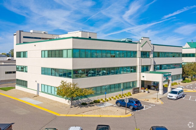
Property Record
305 E Nicollet Blvd, Burnsville, MN 55337


NEARBY LISTINGS FOR SALE OR LEASE
Property Detail
305 E Nicollet Blvd
Minneapolis-St. Paul-Bloomington, MN-WI
Registered Land Survey #53
02-90530-00-030
REGISTERED LAND SURVEY #53 TRACT C
Commercialnec
Dakota
X
Minnesota
27037C0182E
30
2024
0.63 AC
2024
Burnsville/Eagan/Apple Vy
060711
Minneapolis/St Paul
37,320 SF
DEMOGRAPHICS near 305 E Nicollet Blvd
1 Mile
3 Mile
5 Mile
2024 Total Population
11,147
82,410
192,112
2029 Population
11,485
84,085
196,629
Pop Growth 2024-2029
+ 3.03%
+ 2.03%
+ 2.35%
Average Age
39
40
40
2024 Total Households
4,445
32,092
72,574
HH Growth 2024-2029
+ 3.13%
+ 2.11%
+ 2.41%
Median Household Inc
$80,043
$87,365
$95,167
Avg Household Size
2.40
2.50
2.60
2024 Avg HH Vehicles
2.00
2.00
2.00
Median Home Value
$297,987
$313,761
$328,426
Median Year Built
1982
1982
1986
Nearby Places
Map Layers
Map Styles
 Street
 Aerial
- Restaurants
- Banks
- Shops
- Fitness
- Groceries
PUBLIC TRANSPORTATION
AIRPORT
Minneapolis-St Paul International/Wold-Chamberlain
DRIVE
WALK
Distance
Minneapolis-St Paul International/Wold-Chamberlain
22 min
14.2 mi
Freight Ports
Port Milwaukee
DRIVE
WALK
Distance
Port Milwaukee
383 min
345.6 mi
SALE & LEASE HISTORY
LISTING DATE
SALE/LEASE

Sep 25, 2016
For Lease
May 10, 2019
For Lease
Feb 07, 2018
For Lease
Aug 19, 2021
For Lease
Aug 19, 2021
For Lease
Nearby Properties
Address
Land Use
TOTAL SIZE
Lot Size
Zoning
Address
Land Use
TOTAL SIZE
Lot Size
Zoning
339,871 SF
26.64 AC
Address
Land Use
TOTAL SIZE
Lot Size
Zoning
525,323 SF
8.09 AC
Address
Land Use
TOTAL SIZE
Lot Size
Zoning
519,392 SF
17.66 AC
Address
Land Use
TOTAL SIZE
Lot Size
Zoning
584,692 SF
15.70 AC
Address
Land Use
TOTAL SIZE
Lot Size
Zoning
230,883 SF
2.49 AC
Address
Land Use
TOTAL SIZE
Lot Size
Zoning
8.70 AC
Address
Land Use
TOTAL SIZE
Lot Size
Zoning
24,750 SF
14.36 AC
Address
Land Use
TOTAL SIZE
Lot Size
Zoning
394,700 SF
13.23 AC
Address
Land Use
TOTAL SIZE
Lot Size
Zoning
269,828 SF
3.58 AC
Address
Land Use
TOTAL SIZE
Lot Size
Zoning
419,750 SF
13.83 AC
Address
Land Use
TOTAL SIZE
Lot Size
Zoning
374,415 SF
20.10 AC
Address
Land Use
TOTAL SIZE
Lot Size
Zoning
361,645 SF
75.60 AC
Address
Land Use
TOTAL SIZE
Lot Size
Zoning
289,168 SF
11.73 AC
Address
Land Use
TOTAL SIZE
Lot Size
Zoning
265,406 SF
26.78 AC
Address
Land Use
TOTAL SIZE
Lot Size
Zoning
273,843 SF
17.55 AC
Address
Land Use
TOTAL SIZE
Lot Size
Zoning
177,489 SF
1.75 AC
Address
Land Use
TOTAL SIZE
Lot Size
Zoning
276,290 SF
7.44 AC
Address
Land Use
TOTAL SIZE
Lot Size
Zoning
216,267 SF
3.69 AC
Address
Land Use
TOTAL SIZE
Lot Size
Zoning
234,348 SF
11.21 AC
Address
Land Use
TOTAL SIZE
Lot Size
Zoning
174,245 SF
2.90 AC
Address
Land Use
TOTAL SIZE
Lot Size
Zoning
190,865 SF
3.67 AC
Address
Land Use
TOTAL SIZE
Lot Size
Zoning
287,255 SF
14.69 AC
Address
Land Use
TOTAL SIZE
Lot Size
Zoning
239,047 SF
9.14 AC
Address
Land Use
TOTAL SIZE
Lot Size
Zoning
241,204 SF
14.54 AC
Address
Land Use
TOTAL SIZE
Lot Size
Zoning
106,944 SF
13.21 AC
Address
Land Use
TOTAL SIZE
Lot Size
Zoning
256,907 SF
7.43 AC
Address
Land Use
TOTAL SIZE
Lot Size
Zoning
166,705 SF
4.18 AC
Address
Land Use
TOTAL SIZE
Lot Size
Zoning
324,094 SF
44.01 AC
Address
Land Use
TOTAL SIZE
Lot Size
Zoning
120,090 SF
3.16 AC
Address
Land Use
TOTAL SIZE
Lot Size
Zoning
153,369 SF
4.84 AC
The World's #1 Commercial Real Estate Marketplace
Connect with us
© 2026 CoStar Group
The information above has been obtained from sources believed reliable. While we do not doubt its accuracy we have not verified it and make no guarantee, warranty or representation about it. It is your responsibility to independently confirm its accuracy and completeness. Any projections, opinions, assumptions, or estimates used are for example only and do not represent the current or future performance of the property. The value of this transaction to you depends on tax and other factors which should be evaluated by your tax, financial, and legal advisors. You and your advisors should conduct a careful, independent investigation of the property to determine to your satisfaction the suitability of the property for your needs.