Property Record
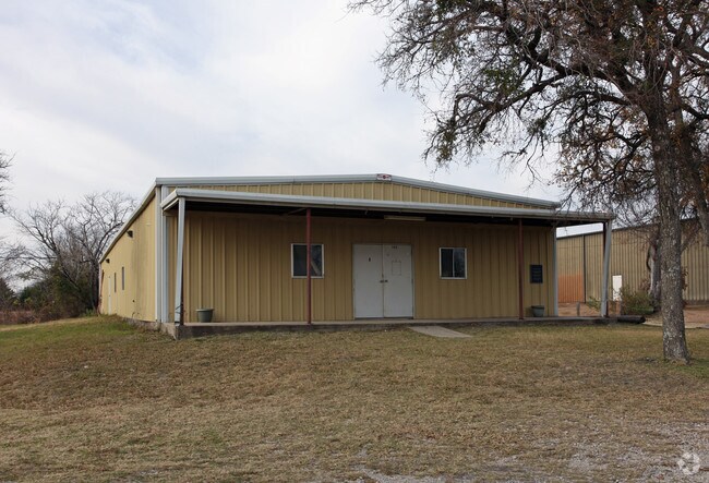
305 E Us Highway 80, Forney, TX 75126


Property Detail
305 E Us Highway 80
6548
JNO GREGG, BLOCK I, TRACT 20B; 4.591 ACRES
Commercialnec
KAUFMAN
AE The base floodplain where base flood elevations are provided. AE Zones are now used on new format FIRMs instead of A1-A30 Zones.
Texas
0
4.59 AC
2025
Forney/Terrll/Kauf Cy
050214
Dallas/Ft Worth
4,000 SF
Dallas-Fort Worth-Arlington, TX
NEARBY LISTINGS FOR SALE OR LEASE
DEMOGRAPHICS near 305 E Us Highway 80
1 mile
3 mile
5 mile
2025 Total Population
11,681
51,635
106,165
2030 Population
15,031
67,017
135,194
Pop Growth 2025-2030
+ 28.68%
+ 29.79%
+ 27.34%
Average Age
34
34
33
2025 Total Households
3,689
16,061
32,144
HH Growth 2025-2030
+ 26.16%
+ 27.48%
+ 25.27%
Median Household Inc
$89,797
$109,307
$107,000
Avg Household Size
3.00
3.10
3.20
2025 Avg HH Vehicles
2.00
2.00
2.00
Median Home Value
$321,151
$375,456
$364,285
Median Year Built
2005
2010
2010
Nearby Places
Map Layers
Map Styles
 Street
 Aerial
Transit
 Traffic
 Biking
Places
Listings with unknown addresses are not visible on the map
- Restaurants
- Banks
- Shops
- Fitness
- Groceries
PUBLIC TRANSPORTATION
AIRPORT
Dallas Love Field
Drive
Walk
Distance
Dallas Love Field
42 min
28.4 mi
Dallas-Fort Worth International
Drive
Walk
Distance
Dallas-Fort Worth International
57 min
46.5 mi
Nearby Properties
Address
Land Use
TOTAL SIZE
Lot Size
Zoning
Address
Land Use
TOTAL SIZE
Lot Size
Zoning
1,214,840 SF
102.04 AC
Address
Land Use
TOTAL SIZE
Lot Size
Zoning
1,120,000 SF
79.53 AC
Address
Land Use
TOTAL SIZE
Lot Size
Zoning
167,350 SF
43.19 AC
Address
Land Use
TOTAL SIZE
Lot Size
Zoning
2,495 SF
46.30 AC
Address
Land Use
TOTAL SIZE
Lot Size
Zoning
48.16 AC
Address
Land Use
TOTAL SIZE
Lot Size
Zoning
201,088 SF
69.99 AC
Address
Land Use
TOTAL SIZE
Lot Size
Zoning
411,440 SF
13 AC
Address
Land Use
TOTAL SIZE
Lot Size
Zoning
124,307 SF
121.73 AC
Address
Land Use
TOTAL SIZE
Lot Size
Zoning
13.42 AC
Address
Land Use
TOTAL SIZE
Lot Size
Zoning
371,550 SF
14.55 AC
Address
Land Use
TOTAL SIZE
Lot Size
Zoning
335,646 SF
14.80 AC
Address
Land Use
TOTAL SIZE
Lot Size
Zoning
126,645 SF
19.94 AC
Address
Land Use
TOTAL SIZE
Lot Size
Zoning
10.13 AC
Address
Land Use
TOTAL SIZE
Lot Size
Zoning
14.08 AC
Address
Land Use
TOTAL SIZE
Lot Size
Zoning
35.49 AC
Address
Land Use
TOTAL SIZE
Lot Size
Zoning
66.34 AC
Address
Land Use
TOTAL SIZE
Lot Size
Zoning
17.34 AC
Address
Land Use
TOTAL SIZE
Lot Size
Zoning
201,861 SF
17.80 AC
Address
Land Use
TOTAL SIZE
Lot Size
Zoning
Address
Land Use
TOTAL SIZE
Lot Size
Zoning
Address
Land Use
TOTAL SIZE
Lot Size
Zoning
54,780 SF
12.94 AC
Address
Land Use
TOTAL SIZE
Lot Size
Zoning
69,835 SF
10.45 AC
Address
Land Use
TOTAL SIZE
Lot Size
Zoning
73,674 SF
8.87 AC
Address
Land Use
TOTAL SIZE
Lot Size
Zoning
9.71 AC
Address
Land Use
TOTAL SIZE
Lot Size
Zoning
310,814 SF
50.06 AC
Address
Land Use
TOTAL SIZE
Lot Size
Zoning
10.47 AC
Address
Land Use
TOTAL SIZE
Lot Size
Zoning
58,817 SF
16 AC
Address
Land Use
TOTAL SIZE
Lot Size
Zoning
75,076 SF
13.20 AC
Address
Land Use
TOTAL SIZE
Lot Size
Zoning
16.45 AC
Address
Land Use
TOTAL SIZE
Lot Size
Zoning
34,466 SF
11.16 AC
The World's #1 Commercial Real Estate Marketplace
Connect with us
© 2026 CoStar Group
The information above has been obtained from sources believed reliable. While we do not doubt its accuracy we have not verified it and make no guarantee, warranty or representation about it. It is your responsibility to independently confirm its accuracy and completeness. Any projections, opinions, assumptions, or estimates used are for example only and do not represent the current or future performance of the property. The value of this transaction to you depends on tax and other factors which should be evaluated by your tax, financial, and legal advisors. You and your advisors should conduct a careful, independent investigation of the property to determine to your satisfaction the suitability of the property for your needs.