Property Record
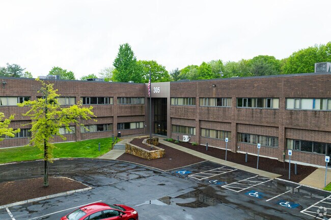
305 Foster St, Littleton, MA 01460


NEARBY LISTINGS FOR SALE OR LEASE
Property Detail
305 Foster St
LITT-000010R-000002-000001
Littleton
Scientificpharmaceuticalmedicalresearchfacility
Middlesex
X
Massachusetts
25017C0219G
1
2025
10.32 AC
2025
Concord/Maynard
324101
Boston
80,403 SF
Boston-Cambridge-Newton, MA-NH
DEMOGRAPHICS near 305 Foster St
1 Mile
3 Mile
5 Mile
2024 Total Population
1,088
15,320
52,185
2029 Population
1,083
15,249
52,104
Pop Growth 2024-2029
(0.46%)
(0.46%)
(0.16%)
Average Age
42
42
42
2024 Total Households
427
5,903
19,748
HH Growth 2024-2029
(0.47%)
(0.56%)
(0.23%)
Median Household Inc
$121,969
$139,945
$145,453
Avg Household Size
2.50
2.60
2.60
2024 Avg HH Vehicles
2.00
2.00
2.00
Median Home Value
$658,654
$637,113
$658,423
Median Year Built
1977
1975
1977
Nearby Places
Map Layers
Map Styles
 Street
 Aerial
- Restaurants
- Banks
- Shops
- Fitness
- Groceries
PUBLIC TRANSPORTATION
TRANSIT/SUBWAY
Littleton/Route 495 (Fitchburg/South Acton Line - Massachusetts Bay Transportation Authority Commuter Rail (Purple Line))
DRIVE
WALK
Distance
Littleton/Route 495 (Fitchburg/South Acton Line - Massachusetts Bay Transportation Authority Commuter Rail (Purple Line))
2 min
11 min
0.6 mi
COMMUTER RAIL
Littleton/Route 495 (Fitchburg/South Acton Line - Massachusetts Bay Transportation Authority Commuter Rail (Purple Line))
DRIVE
WALK
Distance
Littleton/Route 495 (Fitchburg/South Acton Line - Massachusetts Bay Transportation Authority Commuter Rail (Purple Line))
1 min
9 min
0.5 mi
Ayer (Fitchburg/South Acton Line - Massachusetts Bay Transportation Authority Commuter Rail (Purple Line))
DRIVE
WALK
Distance
Ayer (Fitchburg/South Acton Line - Massachusetts Bay Transportation Authority Commuter Rail (Purple Line))
11 min
6.4 mi
AIRPORT
Worcester Regional
DRIVE
WALK
Distance
Worcester Regional
46 min
32.2 mi
General Edward Lawrence Logan International
DRIVE
WALK
Distance
General Edward Lawrence Logan International
52 min
32.3 mi
Manchester Boston Regional
DRIVE
WALK
Distance
Manchester Boston Regional
58 min
37.6 mi
Freight Ports
Port of Boston
DRIVE
WALK
Distance
Port of Boston
52 min
32.4 mi
SALE & LEASE HISTORY
LISTING DATE
SALE/LEASE

Sep 25, 2016
For Lease
Sep 23, 2016
For Sale
Mar 21, 2017
For Lease
Jul 11, 2024
For Lease
Feb 08, 2022
For Lease
Apr 13, 2017
For Lease
Nearby Properties
Address
Land Use
TOTAL SIZE
Lot Size
Zoning
Address
Land Use
TOTAL SIZE
Lot Size
Zoning
312,503 SF
54.44 AC
AR
Address
Land Use
TOTAL SIZE
Lot Size
Zoning
448,759 SF
51.82 AC
IA
Address
Land Use
TOTAL SIZE
Lot Size
Zoning
481,300 SF
69.04 AC
IA
Address
Land Use
TOTAL SIZE
Lot Size
Zoning
54.50 AC
R
Address
Land Use
TOTAL SIZE
Lot Size
Zoning
260,475 SF
70.94 AC
OP
Address
Land Use
TOTAL SIZE
Lot Size
Zoning
143,640 SF
29.44 AC
IA
Address
Land Use
TOTAL SIZE
Lot Size
Zoning
39.84 AC
B
Address
Land Use
TOTAL SIZE
Lot Size
Zoning
374,270 SF
62.74 AC
IA
Address
Land Use
TOTAL SIZE
Lot Size
Zoning
125,160 SF
29.36 AC
R
Address
Land Use
TOTAL SIZE
Lot Size
Zoning
210,620 SF
12.97 AC
Address
Land Use
TOTAL SIZE
Lot Size
Zoning
180,143 SF
41.70 AC
OP
Address
Land Use
TOTAL SIZE
Lot Size
Zoning
131,607 SF
36.01 AC
Address
Land Use
TOTAL SIZE
Lot Size
Zoning
16.44 AC
IA
Address
Land Use
TOTAL SIZE
Lot Size
Zoning
150,515 SF
36.95 AC
OP
Address
Land Use
TOTAL SIZE
Lot Size
Zoning
8.21 AC
R
Address
Land Use
TOTAL SIZE
Lot Size
Zoning
110,150 SF
18.44 AC
Address
Land Use
TOTAL SIZE
Lot Size
Zoning
122,184 SF
8.14 AC
Address
Land Use
TOTAL SIZE
Lot Size
Zoning
154,436 SF
18.86 AC
IA
Address
Land Use
TOTAL SIZE
Lot Size
Zoning
55.50 AC
ARC
Address
Land Use
TOTAL SIZE
Lot Size
Zoning
66,447 SF
11.59 AC
B
Address
Land Use
TOTAL SIZE
Lot Size
Zoning
65,680 SF
7.59 AC
IA
Address
Land Use
TOTAL SIZE
Lot Size
Zoning
97,210 SF
8.28 AC
Address
Land Use
TOTAL SIZE
Lot Size
Zoning
71,395 SF
8.37 AC
C
Address
Land Use
TOTAL SIZE
Lot Size
Zoning
672 SF
183.18 AC
IA
Address
Land Use
TOTAL SIZE
Lot Size
Zoning
98,125 SF
8.97 AC
IA
Address
Land Use
TOTAL SIZE
Lot Size
Zoning
120,612 SF
16.42 AC
Address
Land Use
TOTAL SIZE
Lot Size
Zoning
16.22 AC
IA
Address
Land Use
TOTAL SIZE
Lot Size
Zoning
57,152 SF
20.30 AC
A2
Address
Land Use
TOTAL SIZE
Lot Size
Zoning
108,992 SF
23.90 AC
IA
Address
Land Use
TOTAL SIZE
Lot Size
Zoning
102,793 SF
11.56 AC
OP
The World's #1 Commercial Real Estate Marketplace
Connect with us
© 2026 CoStar Group
The information above has been obtained from sources believed reliable. While we do not doubt its accuracy we have not verified it and make no guarantee, warranty or representation about it. It is your responsibility to independently confirm its accuracy and completeness. Any projections, opinions, assumptions, or estimates used are for example only and do not represent the current or future performance of the property. The value of this transaction to you depends on tax and other factors which should be evaluated by your tax, financial, and legal advisors. You and your advisors should conduct a careful, independent investigation of the property to determine to your satisfaction the suitability of the property for your needs.