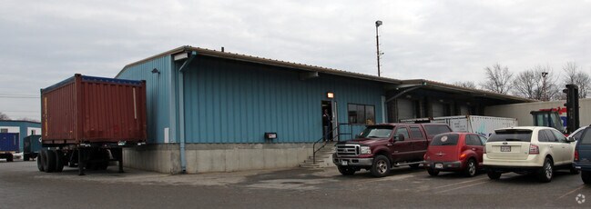
Property Record
305 Industrial Ave E, Lowell, MA 01852


Save to a Folder
{{folder.Name}}
{{folder.ListingIds.length}} Properties
{{folder.ListingIds.length}} Property
Create a New Folder
Property Detail
305 Industrial Ave E
LOWE-000147-003155-000305
MIDDLESEX
Warehouse
Massachusetts
LI
305
B and X Area of moderate flood hazard, usually the area between the limits of the 100-year and 500-year floods.
4.74 AC
2025
Lowell/Chelmsford
2025
Boston
312200
Boston-Cambridge-Newton, MA-NH
9,705 SF
NEARBY LISTINGS FOR SALE OR LEASE
DEMOGRAPHICS near 305 Industrial Ave E
1 mile
3 mile
5 mile
2025 Total Population
21,856
136,760
214,836
2030 Population
22,577
141,026
222,027
Pop Growth 2025-2030
+ 3.30%
+ 3.12%
+ 3.35%
Average Age
37
39
40
2025 Total Households
7,307
49,320
78,904
HH Growth 2025-2030
+ 3.61%
+ 3.35%
+ 3.53%
Median Household Inc
$93,017
$85,930
$97,685
Avg Household Size
2.90
2.60
2.60
2025 Avg HH Vehicles
2.00
2.00
2.00
Median Home Value
$403,317
$470,015
$516,166
Median Year Built
1948
1955
1964
Nearby Places
Map Layers
Map Styles
 Street
 Aerial
Layers
 Traffic
 Biking
Places
Listings with unknown addresses are not visible on the map
- Restaurants
- Banks
- Shops
- Fitness
- Groceries
PUBLIC TRANSPORTATION
COMMUTER RAIL
Lowell (Lowell Line - Massachusetts Bay Transportation Authority Commuter Rail (Purple Line))
Drive
Walk
Distance
Lowell (Lowell Line - Massachusetts Bay Transportation Authority Commuter Rail (Purple Line))
7 min
2.7 mi
North Billerica (Lowell Line - Massachusetts Bay Transportation Authority Commuter Rail (Purple Line))
Drive
Walk
Distance
North Billerica (Lowell Line - Massachusetts Bay Transportation Authority Commuter Rail (Purple Line))
10 min
4.1 mi
AIRPORT
Manchester Boston Regional
Drive
Walk
Distance
Manchester Boston Regional
47 min
30.9 mi
General Edward Lawrence Logan International
Drive
Walk
Distance
General Edward Lawrence Logan International
48 min
34.8 mi
Freight Ports
Port of Boston
Drive
Walk
Distance
Port of Boston
48 min
34.5 mi
Nearby Properties
Address
Land Use
TOTAL SIZE
Lot Size
Zoning
Address
Land Use
TOTAL SIZE
Lot Size
Zoning
9.73 AC
INST
Address
Land Use
TOTAL SIZE
Lot Size
Zoning
14.73 AC
HRC
Address
Land Use
TOTAL SIZE
Lot Size
Zoning
30,744 SF
31.28 AC
INST
Address
Land Use
TOTAL SIZE
Lot Size
Zoning
275,574 SF
6.66 AC
HRCO
Address
Land Use
TOTAL SIZE
Lot Size
Zoning
224,076 SF
1.15 AC
HCD
Address
Land Use
TOTAL SIZE
Lot Size
Zoning
Address
Land Use
TOTAL SIZE
Lot Size
Zoning
215,884 SF
1.55 AC
DMU
Address
Land Use
TOTAL SIZE
Lot Size
Zoning
134,439 SF
3.29 AC
DMU
Address
Land Use
TOTAL SIZE
Lot Size
Zoning
6.30 AC
UMU
Address
Land Use
TOTAL SIZE
Lot Size
Zoning
11.45 AC
TTF
Address
Land Use
TOTAL SIZE
Lot Size
Zoning
2.15 AC
INST
Address
Land Use
TOTAL SIZE
Lot Size
Zoning
15.16 AC
SMF
Address
Land Use
TOTAL SIZE
Lot Size
Zoning
174 SF
IA
Address
Land Use
TOTAL SIZE
Lot Size
Zoning
396,990 SF
48.84 AC
IH
Address
Land Use
TOTAL SIZE
Lot Size
Zoning
19.97 AC
SSF
Address
Land Use
TOTAL SIZE
Lot Size
Zoning
59.09 AC
SSF
Address
Land Use
TOTAL SIZE
Lot Size
Zoning
6.27 AC
DMU
Address
Land Use
TOTAL SIZE
Lot Size
Zoning
225,252 SF
2.31 AC
DMU
Address
Land Use
TOTAL SIZE
Lot Size
Zoning
380,132 SF
35.87 AC
5
Address
Land Use
TOTAL SIZE
Lot Size
Zoning
262,607 SF
4.33 AC
INST
Address
Land Use
TOTAL SIZE
Lot Size
Zoning
10.48 AC
INST
Address
Land Use
TOTAL SIZE
Lot Size
Zoning
7.18 AC
SMF
Address
Land Use
TOTAL SIZE
Lot Size
Zoning
168,114 SF
0.17 AC
UMU
Address
Land Use
TOTAL SIZE
Lot Size
Zoning
38.26 AC
P
Address
Land Use
TOTAL SIZE
Lot Size
Zoning
2.62 AC
INST
Address
Land Use
TOTAL SIZE
Lot Size
Zoning
26.65 AC
IA
Address
Land Use
TOTAL SIZE
Lot Size
Zoning
7.25 AC
INST
Address
Land Use
TOTAL SIZE
Lot Size
Zoning
167,201 SF
6.31 AC
DMU
Address
Land Use
TOTAL SIZE
Lot Size
Zoning
20.88 AC
TSF
Address
Land Use
TOTAL SIZE
Lot Size
Zoning
185,172 SF
2.93 AC
DMU
The World's #1 Commercial Real Estate Marketplace
Connect with us
© 2026 CoStar Group
The information above has been obtained from sources believed reliable. While we do not doubt its accuracy we have not verified it and make no guarantee, warranty or representation about it. It is your responsibility to independently confirm its accuracy and completeness. Any projections, opinions, assumptions, or estimates used are for example only and do not represent the current or future performance of the property. The value of this transaction to you depends on tax and other factors which should be evaluated by your tax, financial, and legal advisors. You and your advisors should conduct a careful, independent investigation of the property to determine to your satisfaction the suitability of the property for your needs.