Property Record
305 Marion Rd, Princeton, KY 42445

Save to a Folder
{{folder.Name}}
{{folder.ListingIds.length}} Properties
{{folder.ListingIds.length}} Property
Create a New Folder
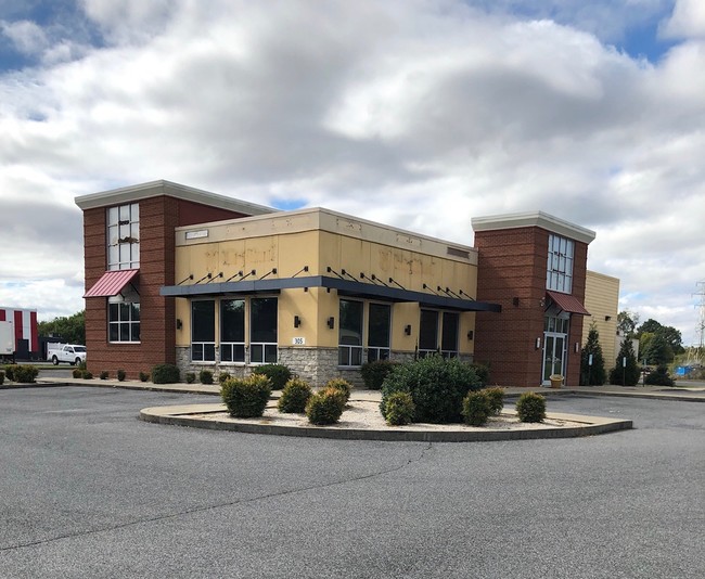
Property Detail
305 Marion Rd
49-104A
BUILDING (FORMER PIZZA HUT) AND 1.14 ACRES
Commercialnec
Caldwell
B and X Area of moderate flood hazard, usually the area between the limits of the 100-year and 500-year floods.
Kentucky
2025
1.14 AC
2025
Kentucky West Area
920200
Other Market Areas
NEARBY LISTINGS FOR SALE OR LEASE
-
-
View all Princeton listings for lease on LoopNet.com
DEMOGRAPHICS near 305 Marion Rd
1 mile
3 mile
5 mile
2025 Total Population
2,289
6,677
7,926
2030 Population
2,272
6,580
7,819
Pop Growth 2025-2030
(0.74%)
(1.45%)
(1.35%)
Average Age
42
42
42
2025 Total Households
988
2,816
3,322
HH Growth 2025-2030
(0.91%)
(1.49%)
(1.38%)
Median Household Inc
$49,230
$49,827
$51,767
Avg Household Size
2.20
2.30
2.30
2025 Avg HH Vehicles
2.00
2.00
2.00
Median Home Value
$76,287
$98,489
$107,177
Median Year Built
1956
1961
1964
Nearby Places
Map Layers
Map Styles
 Street
 Aerial
Layers
 Traffic
 Biking
Places
Listings with unknown addresses are not visible on the map
- Restaurants
- Banks
- Shops
- Fitness
- Groceries
SALE & LEASE HISTORY
LISTING DATE
SALE/LEASE

Nov 06, 2018
For Lease
Nov 06, 2018
For Sale
Nearby Properties
Address
Land Use
TOTAL SIZE
Lot Size
Zoning
Address
Land Use
TOTAL SIZE
Lot Size
Zoning
155,089 SF
22.87 AC
Address
Land Use
TOTAL SIZE
Lot Size
Zoning
5.77 AC
Address
Land Use
TOTAL SIZE
Lot Size
Zoning
1,936 SF
5.77 AC
Address
Land Use
TOTAL SIZE
Lot Size
Zoning
Address
Land Use
TOTAL SIZE
Lot Size
Zoning
Address
Land Use
TOTAL SIZE
Lot Size
Zoning
Address
Land Use
TOTAL SIZE
Lot Size
Zoning
2,982 SF
0.73 AC
Address
Land Use
TOTAL SIZE
Lot Size
Zoning
0.67 AC
Address
Land Use
TOTAL SIZE
Lot Size
Zoning
2,714 SF
0.92 AC
Address
Land Use
TOTAL SIZE
Lot Size
Zoning
2,436 SF
0.65 AC
Address
Land Use
TOTAL SIZE
Lot Size
Zoning
0.70 AC
Address
Land Use
TOTAL SIZE
Lot Size
Zoning
Address
Land Use
TOTAL SIZE
Lot Size
Zoning
Address
Land Use
TOTAL SIZE
Lot Size
Zoning
Address
Land Use
TOTAL SIZE
Lot Size
Zoning
4,820 SF
1.95 AC
Address
Land Use
TOTAL SIZE
Lot Size
Zoning
48,000 SF
7.78 AC
Address
Land Use
TOTAL SIZE
Lot Size
Zoning
3,260 SF
2.37 AC
Address
Land Use
TOTAL SIZE
Lot Size
Zoning
15,718 SF
1.42 AC
Address
Land Use
TOTAL SIZE
Lot Size
Zoning
2,430 SF
0.52 AC
Address
Land Use
TOTAL SIZE
Lot Size
Zoning
Address
Land Use
TOTAL SIZE
Lot Size
Zoning
5,362 SF
1.90 AC
Address
Land Use
TOTAL SIZE
Lot Size
Zoning
6,400 SF
0.65 AC
Address
Land Use
TOTAL SIZE
Lot Size
Zoning
12.32 AC
Address
Land Use
TOTAL SIZE
Lot Size
Zoning
10.74 AC
Address
Land Use
TOTAL SIZE
Lot Size
Zoning
Address
Land Use
TOTAL SIZE
Lot Size
Zoning
12,296 SF
1.68 AC
Address
Land Use
TOTAL SIZE
Lot Size
Zoning
19,392 SF
2 AC
Address
Land Use
TOTAL SIZE
Lot Size
Zoning
1.14 AC
Address
Land Use
TOTAL SIZE
Lot Size
Zoning
1,842 SF
1.38 AC
Address
Land Use
TOTAL SIZE
Lot Size
Zoning
18,000 SF
2 AC
The World's #1 Commercial Real Estate Marketplace
Connect with us
© 2026 CoStar Group
The information above has been obtained from sources believed reliable. While we do not doubt its accuracy we have not verified it and make no guarantee, warranty or representation about it. It is your responsibility to independently confirm its accuracy and completeness. Any projections, opinions, assumptions, or estimates used are for example only and do not represent the current or future performance of the property. The value of this transaction to you depends on tax and other factors which should be evaluated by your tax, financial, and legal advisors. You and your advisors should conduct a careful, independent investigation of the property to determine to your satisfaction the suitability of the property for your needs.