Property Record
305 N 42Nd Ave, Brighton, CO 80601


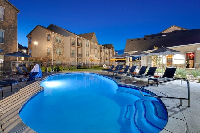
Property Detail
305 N 42Nd Ave
Denver-Aurora-Centennial, CO
BRIGHTON EAST FARMS FLG 1 4TH AMND BLK 35 LOT 1
1569-03-3-02-143
ADAMS
Multifamilydwelling
Colorado
2024
1
2025
12.68 AC
008562
Outer Northeast Adams County
266,280 SF
Denver
NEARBY LISTINGS FOR SALE OR LEASE
DEMOGRAPHICS near 305 N 42Nd Ave
1 mile
3 mile
5 mile
2025 Total Population
9,770
47,682
59,159
2030 Population
10,476
50,969
63,137
Pop Growth 2025-2030
+ 7.23%
+ 6.89%
+ 6.72%
Average Age
37
37
37
2025 Total Households
3,076
15,731
19,569
HH Growth 2025-2030
+ 7.51%
+ 7.18%
+ 6.98%
Median Household Inc
$133,537
$107,840
$105,734
Avg Household Size
3.10
3.00
3.00
2025 Avg HH Vehicles
2.00
2.00
2.00
Median Home Value
$605,986
$506,345
$497,301
Median Year Built
2008
2003
2003
Nearby Places
Map Layers
Map Styles
 Street
 Aerial
Transit
 Traffic
 Biking
Places
Listings with unknown addresses are not visible on the map
- Restaurants
- Banks
- Shops
- Fitness
- Groceries
PUBLIC TRANSPORTATION
AIRPORT
Denver International
Drive
Walk
Distance
Denver International
28 min
20.7 mi
Freight Ports
Tulsa Port Of Catoosa
Drive
Walk
Distance
Tulsa Port Of Catoosa
735 min
714.8 mi
Nearby Properties
Address
Land Use
TOTAL SIZE
Lot Size
Zoning
Address
Land Use
TOTAL SIZE
Lot Size
Zoning
374,830 SF
49.94 AC
Address
Land Use
TOTAL SIZE
Lot Size
Zoning
413,138 SF
20.74 AC
Address
Land Use
TOTAL SIZE
Lot Size
Zoning
275,217 SF
27.30 AC
Address
Land Use
TOTAL SIZE
Lot Size
Zoning
113,764 SF
4.24 AC
Address
Land Use
TOTAL SIZE
Lot Size
Zoning
119,714 SF
4.93 AC
Address
Land Use
TOTAL SIZE
Lot Size
Zoning
116,223 SF
7.38 AC
Address
Land Use
TOTAL SIZE
Lot Size
Zoning
614,010 SF
41.81 AC
Address
Land Use
TOTAL SIZE
Lot Size
Zoning
546,000 SF
35.70 AC
Address
Land Use
TOTAL SIZE
Lot Size
Zoning
1,305,700 SF
103.31 AC
A3
Address
Land Use
TOTAL SIZE
Lot Size
Zoning
526,400 SF
29.21 AC
Address
Land Use
TOTAL SIZE
Lot Size
Zoning
243,589 SF
16.71 AC
Address
Land Use
TOTAL SIZE
Lot Size
Zoning
533,981 SF
112.40 AC
Address
Land Use
TOTAL SIZE
Lot Size
Zoning
11,840 SF
6 AC
Address
Land Use
TOTAL SIZE
Lot Size
Zoning
198,433 SF
40.09 AC
Address
Land Use
TOTAL SIZE
Lot Size
Zoning
352,240 SF
19.96 AC
Address
Land Use
TOTAL SIZE
Lot Size
Zoning
124,238 SF
62.61 AC
Address
Land Use
TOTAL SIZE
Lot Size
Zoning
161,096 SF
82.69 AC
Address
Land Use
TOTAL SIZE
Lot Size
Zoning
300,300 SF
16.38 AC
Address
Land Use
TOTAL SIZE
Lot Size
Zoning
268,226 SF
13.89 AC
Address
Land Use
TOTAL SIZE
Lot Size
Zoning
223,459 SF
27.46 AC
Address
Land Use
TOTAL SIZE
Lot Size
Zoning
274,367 SF
65.77 AC
Address
Land Use
TOTAL SIZE
Lot Size
Zoning
123,627 SF
11.22 AC
Address
Land Use
TOTAL SIZE
Lot Size
Zoning
289,524 SF
15 AC
Address
Land Use
TOTAL SIZE
Lot Size
Zoning
281,164 SF
15.57 AC
Address
Land Use
TOTAL SIZE
Lot Size
Zoning
109,032 SF
13.88 AC
Address
Land Use
TOTAL SIZE
Lot Size
Zoning
61,700 SF
10 AC
Address
Land Use
TOTAL SIZE
Lot Size
Zoning
91,534 SF
23.03 AC
Address
Land Use
TOTAL SIZE
Lot Size
Zoning
85,398 SF
15 AC
The World's #1 Commercial Real Estate Marketplace
Connect with us
© 2026 CoStar Group
The information above has been obtained from sources believed reliable. While we do not doubt its accuracy we have not verified it and make no guarantee, warranty or representation about it. It is your responsibility to independently confirm its accuracy and completeness. Any projections, opinions, assumptions, or estimates used are for example only and do not represent the current or future performance of the property. The value of this transaction to you depends on tax and other factors which should be evaluated by your tax, financial, and legal advisors. You and your advisors should conduct a careful, independent investigation of the property to determine to your satisfaction the suitability of the property for your needs.