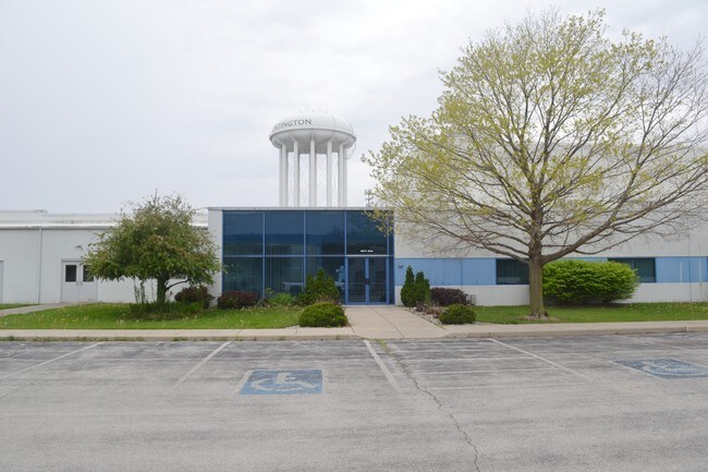
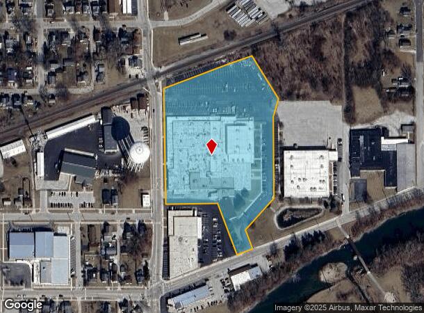
Property Record
305 N Briant St, Huntington, IN 46750
NEARBY LISTINGS FOR SALE OR LEASE
Property Detail
305 N Briant St
35-05-14-200-151.300-005
C E Briants Addition
Storageyardopenstoragelightequipmentmaterial
014-01513-00 EWINGS O L PT O L 12 #C EWINGS O L PT O L 13 #D RE-PL AT 6.5070AC TOTAL
X
Huntington
18069C0163D
Indiana
2024
6.51 AC
2024
Fort Wayne
961600
Other Market Areas
121,416 SF
Huntington, IN
DEMOGRAPHICS near 305 N Briant St
1 Mile
3 Mile
5 Mile
2024 Total Population
10,278
19,877
23,255
2029 Population
10,481
20,145
23,508
Pop Growth 2024-2029
+ 1.98%
+ 1.35%
+ 1.09%
Average Age
38
40
40
2024 Total Households
4,141
8,042
9,382
HH Growth 2024-2029
+ 2.03%
+ 1.41%
+ 1.15%
Median Household Inc
$46,460
$50,244
$52,904
Avg Household Size
2.30
2.30
2.30
2024 Avg HH Vehicles
2.00
2.00
2.00
Median Home Value
$70,257
$95,645
$112,768
Median Year Built
1947
1953
1958
Nearby Places
Map Layers
Map Styles
 Street
 Aerial
- Restaurants
- Banks
- Shops
- Fitness
- Groceries
PUBLIC TRANSPORTATION
AIRPORT
Fort Wayne International
DRIVE
WALK
Distance
Fort Wayne International
34 min
19.6 mi
SALE & LEASE HISTORY
LISTING DATE
SALE/LEASE

Sep 24, 2016
For Lease
Sep 24, 2016
For Sale
Sep 06, 2017
For Lease
Nearby Properties
Address
Land Use
TOTAL SIZE
Lot Size
Zoning
Address
Land Use
TOTAL SIZE
Lot Size
Zoning
197,027 SF
36.29 AC
Address
Land Use
TOTAL SIZE
Lot Size
Zoning
187,224 SF
19.89 AC
Address
Land Use
TOTAL SIZE
Lot Size
Zoning
30.52 AC
Address
Land Use
TOTAL SIZE
Lot Size
Zoning
80,605 SF
9.11 AC
Address
Land Use
TOTAL SIZE
Lot Size
Zoning
210,310 SF
25.18 AC
Address
Land Use
TOTAL SIZE
Lot Size
Zoning
119,200 SF
2.17 AC
Address
Land Use
TOTAL SIZE
Lot Size
Zoning
270,008 SF
28.23 AC
Address
Land Use
TOTAL SIZE
Lot Size
Zoning
55,491 SF
7.24 AC
Address
Land Use
TOTAL SIZE
Lot Size
Zoning
411,066 SF
18.10 AC
Address
Land Use
TOTAL SIZE
Lot Size
Zoning
31,274 SF
11.55 AC
Address
Land Use
TOTAL SIZE
Lot Size
Zoning
67,524 SF
12.03 AC
Address
Land Use
TOTAL SIZE
Lot Size
Zoning
316,816 SF
17.09 AC
Address
Land Use
TOTAL SIZE
Lot Size
Zoning
15.96 AC
Address
Land Use
TOTAL SIZE
Lot Size
Zoning
59,480 SF
15 AC
Address
Land Use
TOTAL SIZE
Lot Size
Zoning
43,916 SF
0.36 AC
Address
Land Use
TOTAL SIZE
Lot Size
Zoning
42,036 SF
0.15 AC
Address
Land Use
TOTAL SIZE
Lot Size
Zoning
72,000 SF
11.39 AC
Address
Land Use
TOTAL SIZE
Lot Size
Zoning
225,560 SF
13.32 AC
Address
Land Use
TOTAL SIZE
Lot Size
Zoning
22,180 SF
24.28 AC
Address
Land Use
TOTAL SIZE
Lot Size
Zoning
154,920 SF
3.45 AC
Address
Land Use
TOTAL SIZE
Lot Size
Zoning
57,829 SF
0.72 AC
Address
Land Use
TOTAL SIZE
Lot Size
Zoning
25,284 SF
10 AC
Address
Land Use
TOTAL SIZE
Lot Size
Zoning
21,102 SF
70.94 AC
Address
Land Use
TOTAL SIZE
Lot Size
Zoning
10,770 SF
8.82 AC
Address
Land Use
TOTAL SIZE
Lot Size
Zoning
67,926 SF
0.91 AC
Address
Land Use
TOTAL SIZE
Lot Size
Zoning
48,175 SF
14.21 AC
Address
Land Use
TOTAL SIZE
Lot Size
Zoning
62,479 SF
29.61 AC
Address
Land Use
TOTAL SIZE
Lot Size
Zoning
27,744 SF
2.40 AC
Address
Land Use
TOTAL SIZE
Lot Size
Zoning
8,360 SF
23.54 AC
Address
Land Use
TOTAL SIZE
Lot Size
Zoning
154,808 SF
31.70 AC
The World's #1 Commercial Real Estate Marketplace
Connect with us
© 2025 CoStar Group
The information above has been obtained from sources believed reliable. While we do not doubt its accuracy we have not verified it and make no guarantee, warranty or representation about it. It is your responsibility to independently confirm its accuracy and completeness. Any projections, opinions, assumptions, or estimates used are for example only and do not represent the current or future performance of the property. The value of this transaction to you depends on tax and other factors which should be evaluated by your tax, financial, and legal advisors. You and your advisors should conduct a careful, independent investigation of the property to determine to your satisfaction the suitability of the property for your needs.