Property Record
305 N Heatherwilde Blvd, Pflugerville, TX 78660
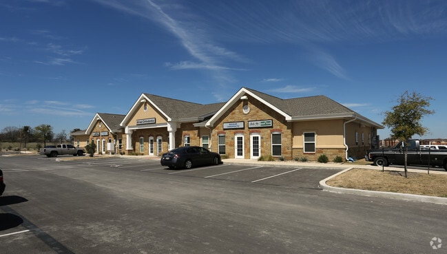

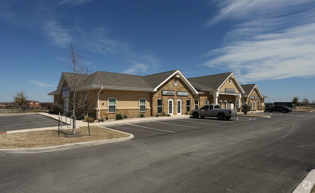
Property Detail
305 N Heatherwilde Blvd
Austin-Round Rock-San Marcos, TX
HEATHERWILDE PROFESSIONAL PARK SUBD BLK 1 LOT 1 & 2
820195
TRAVIS
Officebuilding
Texas
B and X Area of moderate flood hazard, usually the area between the limits of the 100-year and 500-year floods.
1,2
2025
3.54 AC
2025
Far Northeast
042800
Austin
35,644 SF
NEARBY LISTINGS FOR SALE OR LEASE
DEMOGRAPHICS near 305 N Heatherwilde Blvd
1 mile
3 mile
5 mile
2025 Total Population
13,419
103,921
261,312
2030 Population
13,725
108,942
279,004
Pop Growth 2025-2030
+ 2.28%
+ 4.83%
+ 6.77%
Average Age
40
37
37
2025 Total Households
4,885
39,437
100,429
HH Growth 2025-2030
+ 2.91%
+ 5.38%
+ 7.34%
Median Household Inc
$94,555
$96,251
$96,070
Avg Household Size
2.70
2.60
2.60
2025 Avg HH Vehicles
2.00
2.00
2.00
Median Home Value
$351,977
$379,952
$412,116
Median Year Built
1997
2004
2004
Nearby Places
Map Layers
Map Styles
 Street
 Aerial
Layers
 Traffic
 Biking
Places
Listings with unknown addresses are not visible on the map
- Restaurants
- Banks
- Shops
- Fitness
- Groceries
PUBLIC TRANSPORTATION
AIRPORT
Austin-Bergstrom International
Drive
Walk
Distance
Austin-Bergstrom International
38 min
27.0 mi
Freight Ports
Calhoun Port
Drive
Walk
Distance
Calhoun Port
199 min
169.9 mi
Nearby Properties
Address
Land Use
TOTAL SIZE
Lot Size
Zoning
Address
Land Use
TOTAL SIZE
Lot Size
Zoning
2,089,779 SF
167.49 AC
Address
Land Use
TOTAL SIZE
Lot Size
Zoning
956,707 SF
71.90 AC
C1
Address
Land Use
TOTAL SIZE
Lot Size
Zoning
3,842,019 SF
92.55 AC
Address
Land Use
TOTAL SIZE
Lot Size
Zoning
368,100 SF
38.07 AC
Address
Land Use
TOTAL SIZE
Lot Size
Zoning
485,021 SF
50.17 AC
C1
Address
Land Use
TOTAL SIZE
Lot Size
Zoning
491,412 SF
25.66 AC
Address
Land Use
TOTAL SIZE
Lot Size
Zoning
475,624 SF
64.73 AC
Address
Land Use
TOTAL SIZE
Lot Size
Zoning
426,415 SF
50 AC
Address
Land Use
TOTAL SIZE
Lot Size
Zoning
400,695 SF
21.02 AC
Address
Land Use
TOTAL SIZE
Lot Size
Zoning
273,462 SF
47.12 AC
Address
Land Use
TOTAL SIZE
Lot Size
Zoning
541,124 SF
60.17 AC
Address
Land Use
TOTAL SIZE
Lot Size
Zoning
349,128 SF
17.89 AC
Address
Land Use
TOTAL SIZE
Lot Size
Zoning
295,750 SF
21.46 AC
Address
Land Use
TOTAL SIZE
Lot Size
Zoning
371,167 SF
13.18 AC
Address
Land Use
TOTAL SIZE
Lot Size
Zoning
361,440 SF
19.35 AC
Address
Land Use
TOTAL SIZE
Lot Size
Zoning
290,400 SF
42.71 AC
Address
Land Use
TOTAL SIZE
Lot Size
Zoning
377,239 SF
16.95 AC
Address
Land Use
TOTAL SIZE
Lot Size
Zoning
618,605 SF
14.11 AC
PUD
Address
Land Use
TOTAL SIZE
Lot Size
Zoning
326,015 SF
11.11 AC
Address
Land Use
TOTAL SIZE
Lot Size
Zoning
275,550 SF
10.50 AC
Address
Land Use
TOTAL SIZE
Lot Size
Zoning
313,414 SF
37.71 AC
Address
Land Use
TOTAL SIZE
Lot Size
Zoning
341,480 SF
16.35 AC
Address
Land Use
TOTAL SIZE
Lot Size
Zoning
272,250 SF
15.31 AC
Address
Land Use
TOTAL SIZE
Lot Size
Zoning
7,260 SF
93.05 AC
Address
Land Use
TOTAL SIZE
Lot Size
Zoning
346,964 SF
23.41 AC
Address
Land Use
TOTAL SIZE
Lot Size
Zoning
361,338 SF
20 AC
Address
Land Use
TOTAL SIZE
Lot Size
Zoning
344,341 SF
19.19 AC
PUD
Address
Land Use
TOTAL SIZE
Lot Size
Zoning
307,910 SF
20 AC
Address
Land Use
TOTAL SIZE
Lot Size
Zoning
278,578 SF
14.50 AC
Address
Land Use
TOTAL SIZE
Lot Size
Zoning
349,860 SF
16.88 AC
The World's #1 Commercial Real Estate Marketplace
Connect with us
© 2026 CoStar Group
The information above has been obtained from sources believed reliable. While we do not doubt its accuracy we have not verified it and make no guarantee, warranty or representation about it. It is your responsibility to independently confirm its accuracy and completeness. Any projections, opinions, assumptions, or estimates used are for example only and do not represent the current or future performance of the property. The value of this transaction to you depends on tax and other factors which should be evaluated by your tax, financial, and legal advisors. You and your advisors should conduct a careful, independent investigation of the property to determine to your satisfaction the suitability of the property for your needs.