Property Record
305 N Spokane St, Post Falls, ID 83854
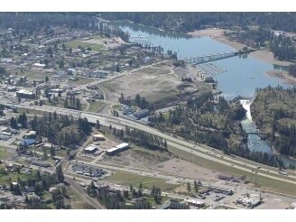

Property Detail
305 N Spokane St
Coeur d'Alene, ID
TAX#1790 EX TX#S, PTN TAX#1015, PTN TAX#1137 ALL EX PLTD PTN & EX RW; HEIRS OF MARGARET POST ESTATES, LT 4-A BLOCK 5 EX
P00000034900
Kootenai
Commercialacreage
Idaho
AE The base floodplain where base flood elevations are provided. AE Zones are now used on new format FIRMs instead of A1-A30 Zones.
4
2025
9.69 AC
2025
Post Falls
000402
Coeur D'Alene
NEARBY LISTINGS FOR SALE OR LEASE
-
-
-
Multiple Commercial/Light Industrial Lots
Post Falls, ID 83854
$431,244 - $6,183,985
0.55 - 4.57 AC Lot
Land
-
-
-
-
-
View all Post Falls listings for sale on LoopNet.com
DEMOGRAPHICS near 305 N Spokane St
1 mile
3 mile
5 mile
2025 Total Population
5,232
44,144
57,630
2030 Population
5,510
46,521
60,756
Pop Growth 2025-2030
+ 5.31%
+ 5.38%
+ 5.42%
Average Age
39
39
40
2025 Total Households
2,117
16,670
21,778
HH Growth 2025-2030
+ 5.43%
+ 5.48%
+ 5.54%
Median Household Inc
$57,385
$68,259
$70,819
Avg Household Size
2.40
2.60
2.60
2025 Avg HH Vehicles
2.00
2.00
2.00
Median Home Value
$434,408
$473,668
$491,284
Median Year Built
1990
2001
2001
Nearby Places
Map Layers
Map Styles
 Street
 Aerial
Transit
 Traffic
 Biking
Places
Listings with unknown addresses are not visible on the map
- Restaurants
- Banks
- Shops
- Fitness
- Groceries
PUBLIC TRANSPORTATION
AIRPORT
Spokane International
Drive
Walk
Distance
Spokane International
39 min
30.0 mi
Freight Ports
Port of Everett
Drive
Walk
Distance
Port of Everett
367 min
325.6 mi
Nearby Properties
Address
Land Use
TOTAL SIZE
Lot Size
Zoning
Address
Land Use
TOTAL SIZE
Lot Size
Zoning
135,646 SF
18.40 AC
Address
Land Use
TOTAL SIZE
Lot Size
Zoning
320,505 SF
60.51 AC
Address
Land Use
TOTAL SIZE
Lot Size
Zoning
89,184 SF
8.69 AC
Address
Land Use
TOTAL SIZE
Lot Size
Zoning
177,574 SF
8.44 AC
Address
Land Use
TOTAL SIZE
Lot Size
Zoning
53,118 SF
7.61 AC
Address
Land Use
TOTAL SIZE
Lot Size
Zoning
130,710 SF
8.23 AC
Address
Land Use
TOTAL SIZE
Lot Size
Zoning
104,852 SF
5.70 AC
Address
Land Use
TOTAL SIZE
Lot Size
Zoning
42,636 SF
24.81 AC
Address
Land Use
TOTAL SIZE
Lot Size
Zoning
94,960 SF
7.45 AC
Address
Land Use
TOTAL SIZE
Lot Size
Zoning
57,936 SF
7.88 AC
Address
Land Use
TOTAL SIZE
Lot Size
Zoning
465,080 SF
31.43 AC
Address
Land Use
TOTAL SIZE
Lot Size
Zoning
265,175 SF
13.74 AC
Address
Land Use
TOTAL SIZE
Lot Size
Zoning
59,629 SF
5.37 AC
Address
Land Use
TOTAL SIZE
Lot Size
Zoning
110,520 SF
4.68 AC
Address
Land Use
TOTAL SIZE
Lot Size
Zoning
112,154 SF
4.61 AC
Address
Land Use
TOTAL SIZE
Lot Size
Zoning
104,855 SF
4.71 AC
Address
Land Use
TOTAL SIZE
Lot Size
Zoning
94,193 SF
18.10 AC
AGSUB
Address
Land Use
TOTAL SIZE
Lot Size
Zoning
82,700 SF
21 AC
Address
Land Use
TOTAL SIZE
Lot Size
Zoning
192,335 SF
18.20 AC
Address
Land Use
TOTAL SIZE
Lot Size
Zoning
57,936 SF
5.28 AC
Address
Land Use
TOTAL SIZE
Lot Size
Zoning
106,656 SF
4.60 AC
Address
Land Use
TOTAL SIZE
Lot Size
Zoning
63,432 SF
7.29 AC
Address
Land Use
TOTAL SIZE
Lot Size
Zoning
108,524 SF
20.34 AC
Address
Land Use
TOTAL SIZE
Lot Size
Zoning
85,000 SF
1.22 AC
Address
Land Use
TOTAL SIZE
Lot Size
Zoning
24,698 SF
44.94 AC
Address
Land Use
TOTAL SIZE
Lot Size
Zoning
16,185 SF
60.19 AC
Address
Land Use
TOTAL SIZE
Lot Size
Zoning
60,246 SF
3.67 AC
Address
Land Use
TOTAL SIZE
Lot Size
Zoning
59,039 SF
4.17 AC
Address
Land Use
TOTAL SIZE
Lot Size
Zoning
103,056 SF
8.18 AC
The World's #1 Commercial Real Estate Marketplace
Connect with us
© 2026 CoStar Group
The information above has been obtained from sources believed reliable. While we do not doubt its accuracy we have not verified it and make no guarantee, warranty or representation about it. It is your responsibility to independently confirm its accuracy and completeness. Any projections, opinions, assumptions, or estimates used are for example only and do not represent the current or future performance of the property. The value of this transaction to you depends on tax and other factors which should be evaluated by your tax, financial, and legal advisors. You and your advisors should conduct a careful, independent investigation of the property to determine to your satisfaction the suitability of the property for your needs.