Property Record
305 N Walnut St, Yellow Springs, OH 45387


NEARBY LISTINGS FOR SALE OR LEASE
-
-
View all Yellow Springs listings for sale on LoopNet.com
Property Detail
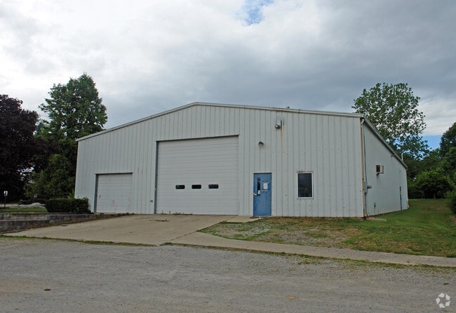
305 N Walnut St
F19-0001-0011-0-0259-00
Yellow Springs
Warehouse
8-4-20 N END DP&L EASEMENT 305 N WALNUT ST
X
Greene
39057C0045E
Ohio
2024
3 AC
2024
Southeast Dayton
255000
Cincinnati/Dayton
1,752 SF
Dayton, OH
DEMOGRAPHICS near 305 N Walnut St
1 Mile
3 Mile
5 Mile
2024 Total Population
2,649
4,983
12,461
2029 Population
2,687
5,007
12,379
Pop Growth 2024-2029
+ 1.43%
+ 0.48%
(0.66%)
Average Age
48
48
46
2024 Total Households
1,321
2,319
5,346
HH Growth 2024-2029
+ 1.51%
+ 0.69%
(0.54%)
Median Household Inc
$57,349
$76,885
$84,653
Avg Household Size
1.90
2.10
2.20
2024 Avg HH Vehicles
2.00
2.00
2.00
Median Home Value
$264,683
$270,396
$244,261
Median Year Built
1953
1957
1965
Nearby Places
Map Layers
Map Styles
 Street
 Aerial
- Restaurants
- Banks
- Shops
- Fitness
- Groceries
PUBLIC TRANSPORTATION
AIRPORT
James M Cox Dayton International
DRIVE
WALK
Distance
James M Cox Dayton International
40 min
25.1 mi
Freight Ports
Port of Toledo
DRIVE
WALK
Distance
Port of Toledo
196 min
139.8 mi
Nearby Properties
Address
Land Use
TOTAL SIZE
Lot Size
Zoning
Address
Land Use
TOTAL SIZE
Lot Size
Zoning
91,970 SF
11.14 AC
Address
Land Use
TOTAL SIZE
Lot Size
Zoning
22,410 SF
42.80 AC
Address
Land Use
TOTAL SIZE
Lot Size
Zoning
28,625 SF
8.23 AC
Address
Land Use
TOTAL SIZE
Lot Size
Zoning
127,420 SF
25 AC
I-1
Address
Land Use
TOTAL SIZE
Lot Size
Zoning
1,528 SF
496.07 AC
Address
Land Use
TOTAL SIZE
Lot Size
Zoning
50,072 SF
32.22 AC
Address
Land Use
TOTAL SIZE
Lot Size
Zoning
26,909 SF
17.50 AC
Address
Land Use
TOTAL SIZE
Lot Size
Zoning
938 SF
297 AC
Address
Land Use
TOTAL SIZE
Lot Size
Zoning
50,200 SF
8.56 AC
Address
Land Use
TOTAL SIZE
Lot Size
Zoning
32,202 SF
1.61 AC
Address
Land Use
TOTAL SIZE
Lot Size
Zoning
27,117 SF
92.38 AC
A-1
Address
Land Use
TOTAL SIZE
Lot Size
Zoning
26,687 SF
8.84 AC
Address
Land Use
TOTAL SIZE
Lot Size
Zoning
68,010 SF
60.08 AC
Address
Land Use
TOTAL SIZE
Lot Size
Zoning
4,365 SF
251.15 AC
Address
Land Use
TOTAL SIZE
Lot Size
Zoning
65,740 SF
5.95 AC
I-1
Address
Land Use
TOTAL SIZE
Lot Size
Zoning
37,436 SF
2.85 AC
Address
Land Use
TOTAL SIZE
Lot Size
Zoning
8,356 SF
1.58 AC
Address
Land Use
TOTAL SIZE
Lot Size
Zoning
2,100 SF
15.41 AC
Address
Land Use
TOTAL SIZE
Lot Size
Zoning
5,760 SF
7.81 AC
Address
Land Use
TOTAL SIZE
Lot Size
Zoning
31,956 SF
12 AC
Address
Land Use
TOTAL SIZE
Lot Size
Zoning
25,500 SF
10.22 AC
Address
Land Use
TOTAL SIZE
Lot Size
Zoning
31,330 SF
2.61 AC
Address
Land Use
TOTAL SIZE
Lot Size
Zoning
92,982 SF
7.61 AC
Address
Land Use
TOTAL SIZE
Lot Size
Zoning
2,050 SF
114.48 AC
Address
Land Use
TOTAL SIZE
Lot Size
Zoning
19,080 SF
12.09 AC
Address
Land Use
TOTAL SIZE
Lot Size
Zoning
244.03 AC
Address
Land Use
TOTAL SIZE
Lot Size
Zoning
2,802 SF
194.69 AC
Address
Land Use
TOTAL SIZE
Lot Size
Zoning
2,502 SF
205.38 AC
Address
Land Use
TOTAL SIZE
Lot Size
Zoning
2,096 SF
35.56 AC
Address
Land Use
TOTAL SIZE
Lot Size
Zoning
1,095 SF
217.49 AC
The World's #1 Commercial Real Estate Marketplace
Connect with us
© 2026 CoStar Group
The information above has been obtained from sources believed reliable. While we do not doubt its accuracy we have not verified it and make no guarantee, warranty or representation about it. It is your responsibility to independently confirm its accuracy and completeness. Any projections, opinions, assumptions, or estimates used are for example only and do not represent the current or future performance of the property. The value of this transaction to you depends on tax and other factors which should be evaluated by your tax, financial, and legal advisors. You and your advisors should conduct a careful, independent investigation of the property to determine to your satisfaction the suitability of the property for your needs.