Property Record
305 Naeco Way, Peachtree City, GA 30269
NEARBY LISTINGS FOR SALE OR LEASE
-
-
View all Peachtree City listings for sale on LoopNet.com
Property Detail
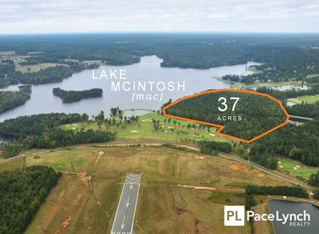
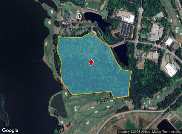
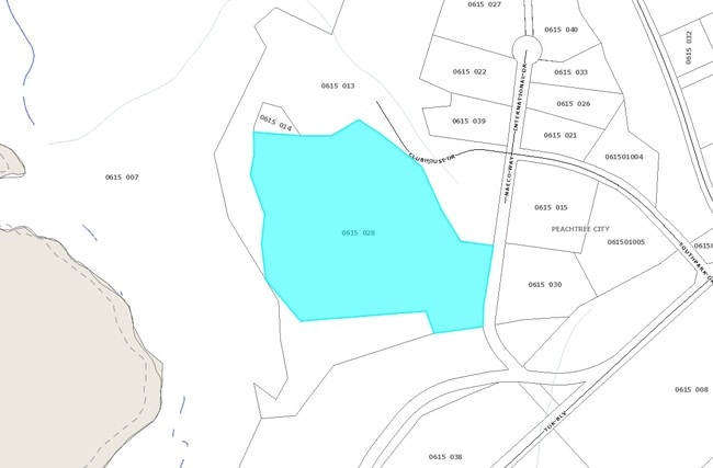
305 Naeco Way
Atlanta-Sandy Springs-Roswell, GA
Peachtree City Holdings Llc
06-15-00-028
36.98 ACRES OFF SOUTHPARK DR
Industrialacreage
Fayette
X
Georgia
13077C0280D
36.98 AC
2024
Fayette/Coweta County
2024
Atlanta
140303
DEMOGRAPHICS near 305 Naeco Way
1 Mile
3 Mile
5 Mile
2024 Total Population
537
23,271
58,806
2029 Population
571
24,799
63,084
Pop Growth 2024-2029
+ 6.33%
+ 6.57%
+ 7.27%
Average Age
41
42
42
2024 Total Households
184
8,848
21,518
HH Growth 2024-2029
+ 5.98%
+ 6.61%
+ 7.27%
Median Household Inc
$129,762
$92,265
$99,255
Avg Household Size
2.80
2.60
2.70
2024 Avg HH Vehicles
3.00
2.00
2.00
Median Home Value
$451,041
$347,817
$380,477
Median Year Built
1991
1988
1993
Nearby Places
- Restaurants
- Banks
- Shops
- Fitness
- Groceries
PUBLIC TRANSPORTATION
AIRPORT
Hartsfield - Jackson Atlanta International
DRIVE
WALK
Distance
Hartsfield - Jackson Atlanta International
44 min
28.3 mi
Freight Ports
Georgia Ports - Savannah
DRIVE
WALK
Distance
Georgia Ports - Savannah
284 min
243.8 mi
SALE & LEASE HISTORY
LISTING DATE
SALE/LEASE

Sep 24, 2016
For Sale
Nearby Properties
Address
Land Use
TOTAL SIZE
Lot Size
Zoning
Address
Land Use
TOTAL SIZE
Lot Size
Zoning
171,535 SF
27.60 AC
C GC
Address
Land Use
TOTAL SIZE
Lot Size
Zoning
384,330 SF
228 AC
I GI
Address
Land Use
TOTAL SIZE
Lot Size
Zoning
74,557 SF
43.31 AC
I GI
Address
Land Use
TOTAL SIZE
Lot Size
Zoning
274,599 SF
28.10 AC
C GR12
Address
Land Use
TOTAL SIZE
Lot Size
Zoning
70,241 SF
11.09 AC
C GR14
Address
Land Use
TOTAL SIZE
Lot Size
Zoning
214,866 SF
10.96 AC
I GI
Address
Land Use
TOTAL SIZE
Lot Size
Zoning
163,447 SF
18.70 AC
C LUC
Address
Land Use
TOTAL SIZE
Lot Size
Zoning
156,113 SF
25.37 AC
001
Address
Land Use
TOTAL SIZE
Lot Size
Zoning
218,763 SF
38.40 AC
C GC
Address
Land Use
TOTAL SIZE
Lot Size
Zoning
87,848 SF
33.20 AC
C GI
Address
Land Use
TOTAL SIZE
Lot Size
Zoning
123,051 SF
20.80 AC
C GR12
Address
Land Use
TOTAL SIZE
Lot Size
Zoning
262,058 SF
44.79 AC
C GC
Address
Land Use
TOTAL SIZE
Lot Size
Zoning
89,736 SF
11.56 AC
C GC
Address
Land Use
TOTAL SIZE
Lot Size
Zoning
75,217 SF
15 AC
CS
Address
Land Use
TOTAL SIZE
Lot Size
Zoning
202,691 SF
24.65 AC
C GC
Address
Land Use
TOTAL SIZE
Lot Size
Zoning
309,402 SF
32.02 AC
I GI
Address
Land Use
TOTAL SIZE
Lot Size
Zoning
261,976 SF
43.41 AC
I GI
Address
Land Use
TOTAL SIZE
Lot Size
Zoning
82,744 SF
19.94 AC
Address
Land Use
TOTAL SIZE
Lot Size
Zoning
93,072 SF
28.10 AC
C LUC
Address
Land Use
TOTAL SIZE
Lot Size
Zoning
75,052 SF
18.90 AC
Address
Land Use
TOTAL SIZE
Lot Size
Zoning
32,126 SF
8.41 AC
C LUC
Address
Land Use
TOTAL SIZE
Lot Size
Zoning
72,703 SF
8 AC
C GC
Address
Land Use
TOTAL SIZE
Lot Size
Zoning
377,939 SF
14.42 AC
I GI
Address
Land Use
TOTAL SIZE
Lot Size
Zoning
47,505 SF
9.83 AC
I GI
Address
Land Use
TOTAL SIZE
Lot Size
Zoning
214.97 AC
Address
Land Use
TOTAL SIZE
Lot Size
Zoning
44,100 SF
4.69 AC
I GI
Address
Land Use
TOTAL SIZE
Lot Size
Zoning
784 SF
517.26 AC
RFA
Address
Land Use
TOTAL SIZE
Lot Size
Zoning
160,007 SF
20.10 AC
I GI
Address
Land Use
TOTAL SIZE
Lot Size
Zoning
184,564 SF
19.13 AC
I GI
Address
Land Use
TOTAL SIZE
Lot Size
Zoning
86,761 SF
6.35 AC
C LUC
The World's #1 Commercial Real Estate Marketplace
Connect with us
© 2025 CoStar Group
The information above has been obtained from sources believed reliable. While we do not doubt its accuracy we have not verified it and make no guarantee, warranty or representation about it. It is your responsibility to independently confirm its accuracy and completeness. Any projections, opinions, assumptions, or estimates used are for example only and do not represent the current or future performance of the property. The value of this transaction to you depends on tax and other factors which should be evaluated by your tax, financial, and legal advisors. You and your advisors should conduct a careful, independent investigation of the property to determine to your satisfaction the suitability of the property for your needs.