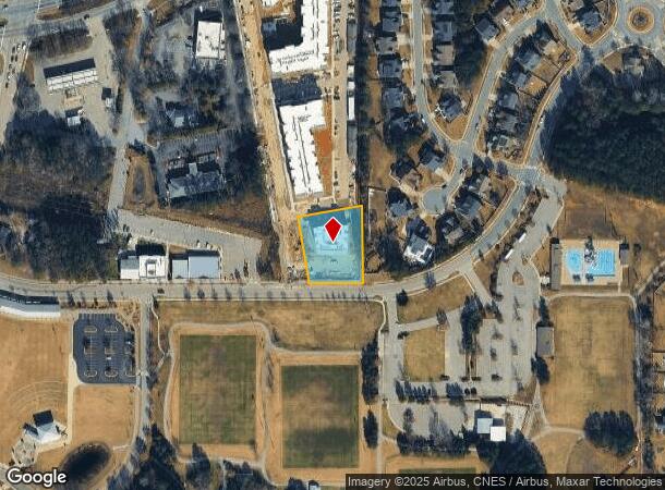
Property Record
305 Sugar Magnolia Ln, Knightdale, NC 27545
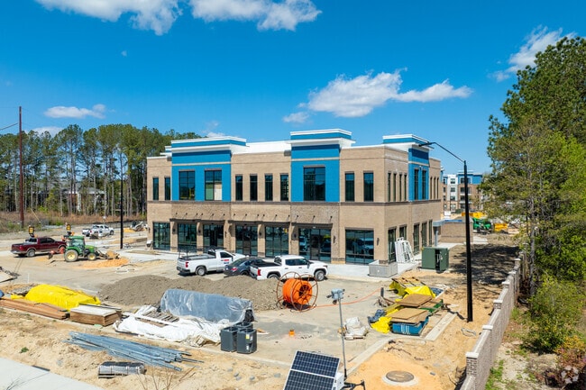
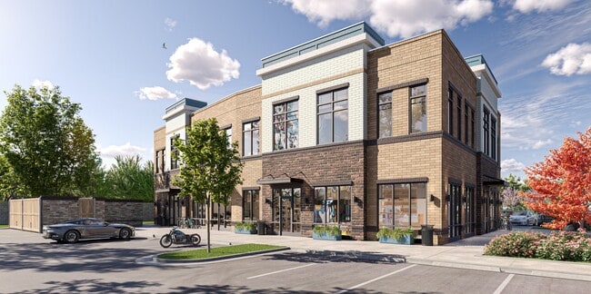
This Property Is For Sale
Current Lease Availabilities
NEARBY LISTINGS FOR SALE OR LEASE
Property Detail
305 Sugar Magnolia Ln
Raleigh/Durham
The Lofts At Knightdale Station
Raleigh, NC
LO2 THE LOFTS AT KNIGHTDALE STATION BM20
1754.11-65-6562-000
Wake
Commercialnec
North Carolina
2025
2
2025
0.83 AC
054115
Northeast Wake County
10,536 SF
DEMOGRAPHICS near 305 Sugar Magnolia Ln
1 Mile
3 Mile
5 Mile
2024 Total Population
4,275
30,646
76,539
2029 Population
5,144
36,398
90,541
Pop Growth 2024-2029
+ 20.33%
+ 18.77%
+ 18.29%
Average Age
38
38
38
2024 Total Households
1,563
11,438
28,523
HH Growth 2024-2029
+ 20.99%
+ 19.60%
+ 19.12%
Median Household Inc
$72,793
$69,653
$80,892
Avg Household Size
2.70
2.70
2.60
2024 Avg HH Vehicles
2.00
2.00
2.00
Median Home Value
$334,434
$265,201
$281,256
Median Year Built
2005
2001
2000
Nearby Places
- Restaurants
- Banks
- Shops
- Fitness
- Groceries
PUBLIC TRANSPORTATION
AIRPORT
Raleigh-Durham International
DRIVE
WALK
Distance
Raleigh-Durham International
33 min
25.4 mi
Freight Ports
Port of Wilmington
DRIVE
WALK
Distance
Port of Wilmington
162 min
136.5 mi
Nearby Properties
Address
Land Use
TOTAL SIZE
Lot Size
Zoning
Address
Land Use
TOTAL SIZE
Lot Size
Zoning
358,360 SF
20.25 AC
HBCD
Address
Land Use
TOTAL SIZE
Lot Size
Zoning
392,729 SF
72.10 AC
CU-O&
Address
Land Use
TOTAL SIZE
Lot Size
Zoning
301,933 SF
12.92 AC
PUD-1
Address
Land Use
TOTAL SIZE
Lot Size
Zoning
328,918 SF
17.24 AC
CMX-C
Address
Land Use
TOTAL SIZE
Lot Size
Zoning
320,135 SF
17.75 AC
NMX
Address
Land Use
TOTAL SIZE
Lot Size
Zoning
261,096 SF
17.30 AC
NMX
Address
Land Use
TOTAL SIZE
Lot Size
Zoning
263,074 SF
83.23 AC
GR8
Address
Land Use
TOTAL SIZE
Lot Size
Zoning
209,019 SF
5 AC
NMX P
Address
Land Use
TOTAL SIZE
Lot Size
Zoning
222,108 SF
21.81 AC
UR12
Address
Land Use
TOTAL SIZE
Lot Size
Zoning
250,778 SF
16.51 AC
UR12
Address
Land Use
TOTAL SIZE
Lot Size
Zoning
299,965 SF
16.34 AC
RMX
Address
Land Use
TOTAL SIZE
Lot Size
Zoning
206,543 SF
19.91 AC
UR12
Address
Land Use
TOTAL SIZE
Lot Size
Zoning
411,764 SF
59.16 AC
MI
Address
Land Use
TOTAL SIZE
Lot Size
Zoning
165,191 SF
17.76 AC
HB
Address
Land Use
TOTAL SIZE
Lot Size
Zoning
250,120 SF
17.38 AC
MI CD
Address
Land Use
TOTAL SIZE
Lot Size
Zoning
208,125 SF
26.29 AC
MI
Address
Land Use
TOTAL SIZE
Lot Size
Zoning
180,000 SF
24.61 AC
MI CD
Address
Land Use
TOTAL SIZE
Lot Size
Zoning
155,462 SF
4.57 AC
NMX P
Address
Land Use
TOTAL SIZE
Lot Size
Zoning
81,915 SF
18.72 AC
CH
Address
Land Use
TOTAL SIZE
Lot Size
Zoning
121,658 SF
5.51 AC
NMX
Address
Land Use
TOTAL SIZE
Lot Size
Zoning
96,023 SF
18.79 AC
MI
Address
Land Use
TOTAL SIZE
Lot Size
Zoning
61,750 SF
12.01 AC
PUD-1
Address
Land Use
TOTAL SIZE
Lot Size
Zoning
138,588 SF
19.07 AC
HB CD
Address
Land Use
TOTAL SIZE
Lot Size
Zoning
136,430 SF
52.66 AC
GR8
Address
Land Use
TOTAL SIZE
Lot Size
Zoning
63,414 SF
95.15 AC
RT
Address
Land Use
TOTAL SIZE
Lot Size
Zoning
103,924 SF
16.92 AC
GR8
Address
Land Use
TOTAL SIZE
Lot Size
Zoning
111,921 SF
8.05 AC
UR12
Address
Land Use
TOTAL SIZE
Lot Size
Zoning
120,000 SF
7.40 AC
MI
Address
Land Use
TOTAL SIZE
Lot Size
Zoning
84,409 SF
10.15 AC
HB
Address
Land Use
TOTAL SIZE
Lot Size
Zoning
120,000 SF
7.56 AC
MI
The World's #1 Commercial Real Estate Marketplace
Connect with us
© 2025 CoStar Group
The information above has been obtained from sources believed reliable. While we do not doubt its accuracy we have not verified it and make no guarantee, warranty or representation about it. It is your responsibility to independently confirm its accuracy and completeness. Any projections, opinions, assumptions, or estimates used are for example only and do not represent the current or future performance of the property. The value of this transaction to you depends on tax and other factors which should be evaluated by your tax, financial, and legal advisors. You and your advisors should conduct a careful, independent investigation of the property to determine to your satisfaction the suitability of the property for your needs.