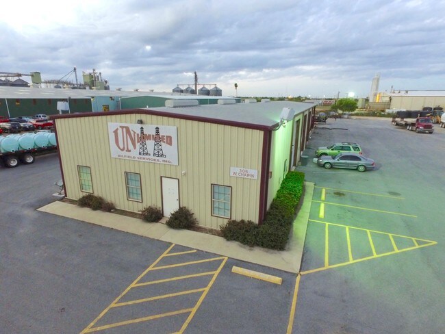
Property Record
305 W Chapin St, Edinburg, TX 78541

NEARBY LISTINGS FOR SALE OR LEASE
Property Detail
305 W Chapin St
McAllen/Edinburg/Pharr
Tex-Mex Survey
McAllen-Edinburg-Mission, TX
TEX-MEX SURVEY W290-E940-S418 LOT 6 BLK 241 2.78AC GR 2.58AC NET
T2100-00-241-0006-07
Hidalgo
Commercialnec
Texas
2024
6
2025
2.58 AC
024003
Edinburg
3,880 SF
DEMOGRAPHICS near 305 W Chapin St
1 Mile
3 Mile
5 Mile
2024 Total Population
8,957
73,145
141,129
2029 Population
9,461
76,924
148,737
Pop Growth 2024-2029
+ 5.63%
+ 5.17%
+ 5.39%
Average Age
31
33
33
2024 Total Households
3,077
24,230
44,251
HH Growth 2024-2029
+ 5.49%
+ 5.02%
+ 5.32%
Median Household Inc
$34,768
$48,472
$52,243
Avg Household Size
2.80
2.90
3.10
2024 Avg HH Vehicles
2.00
2.00
2.00
Median Home Value
$114,960
$152,317
$156,634
Median Year Built
2002
2000
2002
Nearby Places
Map Layers
Map Styles
 Street
 Aerial
- Restaurants
- Banks
- Shops
- Fitness
- Groceries
PUBLIC TRANSPORTATION
AIRPORT
McAllen International
DRIVE
WALK
Distance
McAllen International
19 min
13.7 mi
Freight Ports
Port of Brownsville
DRIVE
WALK
Distance
Port of Brownsville
74 min
64.9 mi
SALE & LEASE HISTORY
LISTING DATE
SALE/LEASE

Oct 27, 2016
For Sale
Oct 04, 2017
For Sale
Dec 30, 2016
For Sale
Dec 19, 2018
For Sale
Nearby Properties
Address
Land Use
TOTAL SIZE
Lot Size
Zoning
Address
Land Use
TOTAL SIZE
Lot Size
Zoning
11 SF
63.14 AC
Address
Land Use
TOTAL SIZE
Lot Size
Zoning
414,619 SF
9.75 AC
Address
Land Use
TOTAL SIZE
Lot Size
Zoning
139,242 SF
29.92 AC
Address
Land Use
TOTAL SIZE
Lot Size
Zoning
58,160 SF
36.96 AC
CO
Address
Land Use
TOTAL SIZE
Lot Size
Zoning
109,791 SF
8.82 AC
Address
Land Use
TOTAL SIZE
Lot Size
Zoning
1 SF
27.89 AC
Address
Land Use
TOTAL SIZE
Lot Size
Zoning
1 SF
35.30 AC
Address
Land Use
TOTAL SIZE
Lot Size
Zoning
119,225 SF
23.30 AC
CO
Address
Land Use
TOTAL SIZE
Lot Size
Zoning
2 SF
32.26 AC
CO
Address
Land Use
TOTAL SIZE
Lot Size
Zoning
86,008 SF
10 AC
Address
Land Use
TOTAL SIZE
Lot Size
Zoning
5 SF
22.02 AC
Address
Land Use
TOTAL SIZE
Lot Size
Zoning
195,599 SF
21.46 AC
CO
Address
Land Use
TOTAL SIZE
Lot Size
Zoning
1 SF
17.61 AC
CO
Address
Land Use
TOTAL SIZE
Lot Size
Zoning
22,199 SF
1.96 AC
Address
Land Use
TOTAL SIZE
Lot Size
Zoning
122,692 SF
16.47 AC
Address
Land Use
TOTAL SIZE
Lot Size
Zoning
2 SF
37.14 AC
Address
Land Use
TOTAL SIZE
Lot Size
Zoning
10,333 SF
36.75 AC
Address
Land Use
TOTAL SIZE
Lot Size
Zoning
138,503 SF
24.24 AC
Address
Land Use
TOTAL SIZE
Lot Size
Zoning
73,272 SF
32.88 AC
Address
Land Use
TOTAL SIZE
Lot Size
Zoning
31.95 AC
Address
Land Use
TOTAL SIZE
Lot Size
Zoning
70,571 SF
14.31 AC
C
Address
Land Use
TOTAL SIZE
Lot Size
Zoning
7 SF
16.63 AC
Address
Land Use
TOTAL SIZE
Lot Size
Zoning
9 SF
36.37 AC
Address
Land Use
TOTAL SIZE
Lot Size
Zoning
76,685 SF
1.38 AC
Address
Land Use
TOTAL SIZE
Lot Size
Zoning
123,257 SF
5.70 AC
Address
Land Use
TOTAL SIZE
Lot Size
Zoning
252,640 SF
19.23 AC
Address
Land Use
TOTAL SIZE
Lot Size
Zoning
41,930 SF
3 AC
CO
Address
Land Use
TOTAL SIZE
Lot Size
Zoning
63,284 SF
15.29 AC
Address
Land Use
TOTAL SIZE
Lot Size
Zoning
198,456 SF
20.22 AC
RM
Address
Land Use
TOTAL SIZE
Lot Size
Zoning
3,890 SF
12.43 AC
The World's #1 Commercial Real Estate Marketplace
Connect with us
© 2025 CoStar Group
The information above has been obtained from sources believed reliable. While we do not doubt its accuracy we have not verified it and make no guarantee, warranty or representation about it. It is your responsibility to independently confirm its accuracy and completeness. Any projections, opinions, assumptions, or estimates used are for example only and do not represent the current or future performance of the property. The value of this transaction to you depends on tax and other factors which should be evaluated by your tax, financial, and legal advisors. You and your advisors should conduct a careful, independent investigation of the property to determine to your satisfaction the suitability of the property for your needs.