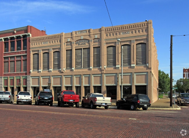
Property Record
305 W Woodard St, Denison, TX 75020


NEARBY LISTINGS FOR SALE OR LEASE
Property Detail
305 W Woodard St
Sherman-Denison, TX
Otp Denison
143045
OTP DENISON, BLOCK 37, LOT 20 THRU 24, 125 X 120 (C) 15000 SQ FT, ACRES .3444
Commercialnec
Grayson
X
Texas
40013C0500E
20-24
2024
0.34 AC
2025
Texas East Area
000502
Other Market Areas
5,000 SF
DEMOGRAPHICS near 305 W Woodard St
1 Mile
3 Mile
5 Mile
2024 Total Population
8,985
26,375
34,233
2029 Population
10,426
30,300
39,250
Pop Growth 2024-2029
+ 16.04%
+ 14.88%
+ 14.66%
Average Age
38
40
41
2024 Total Households
3,495
10,456
13,621
HH Growth 2024-2029
+ 16.51%
+ 15.36%
+ 15.17%
Median Household Inc
$52,739
$53,308
$58,276
Avg Household Size
2.50
2.40
2.40
2024 Avg HH Vehicles
2.00
2.00
2.00
Median Home Value
$104,854
$148,366
$171,542
Median Year Built
1960
1968
1974
Nearby Places
Map Layers
Map Styles
 Street
 Aerial
- Restaurants
- Banks
- Shops
- Fitness
- Groceries
SALE & LEASE HISTORY
LISTING DATE
SALE/LEASE

Sep 25, 2016
For Lease
Sep 17, 2019
For Lease
Mar 01, 2021
For Lease
Feb 09, 2017
For Lease
Aug 04, 2020
For Lease
Nearby Properties
Address
Land Use
TOTAL SIZE
Lot Size
Zoning
Address
Land Use
TOTAL SIZE
Lot Size
Zoning
452,240 SF
128.83 AC
Address
Land Use
TOTAL SIZE
Lot Size
Zoning
362,322 SF
33.08 AC
Address
Land Use
TOTAL SIZE
Lot Size
Zoning
71,582 SF
23.83 AC
Address
Land Use
TOTAL SIZE
Lot Size
Zoning
66,077 SF
10 AC
Address
Land Use
TOTAL SIZE
Lot Size
Zoning
263,952 SF
34.25 AC
Address
Land Use
TOTAL SIZE
Lot Size
Zoning
69,762 SF
12.13 AC
Address
Land Use
TOTAL SIZE
Lot Size
Zoning
112,048 SF
8.66 AC
Address
Land Use
TOTAL SIZE
Lot Size
Zoning
63,575 SF
2.07 AC
Address
Land Use
TOTAL SIZE
Lot Size
Zoning
173,887 SF
20.23 AC
Address
Land Use
TOTAL SIZE
Lot Size
Zoning
70,845 SF
14.29 AC
Address
Land Use
TOTAL SIZE
Lot Size
Zoning
76,800 SF
5.02 AC
Address
Land Use
TOTAL SIZE
Lot Size
Zoning
52,950 SF
2 AC
Address
Land Use
TOTAL SIZE
Lot Size
Zoning
234,696 SF
29.16 AC
Address
Land Use
TOTAL SIZE
Lot Size
Zoning
66,216 SF
10.15 AC
Address
Land Use
TOTAL SIZE
Lot Size
Zoning
75,232 SF
23.82 AC
Address
Land Use
TOTAL SIZE
Lot Size
Zoning
97,136 SF
6.38 AC
Address
Land Use
TOTAL SIZE
Lot Size
Zoning
123,440 SF
9.29 AC
Address
Land Use
TOTAL SIZE
Lot Size
Zoning
67,952 SF
4.72 AC
Address
Land Use
TOTAL SIZE
Lot Size
Zoning
135,984 SF
9.21 AC
Address
Land Use
TOTAL SIZE
Lot Size
Zoning
49,174 SF
1.90 AC
Address
Land Use
TOTAL SIZE
Lot Size
Zoning
6,354 SF
12.45 AC
Address
Land Use
TOTAL SIZE
Lot Size
Zoning
47,508 SF
2.89 AC
Address
Land Use
TOTAL SIZE
Lot Size
Zoning
86,354 SF
7.91 AC
Address
Land Use
TOTAL SIZE
Lot Size
Zoning
141,948 SF
33.33 AC
Address
Land Use
TOTAL SIZE
Lot Size
Zoning
13,800 SF
8.50 AC
Address
Land Use
TOTAL SIZE
Lot Size
Zoning
56,000 SF
13.48 AC
Address
Land Use
TOTAL SIZE
Lot Size
Zoning
258,717 SF
23.04 AC
Address
Land Use
TOTAL SIZE
Lot Size
Zoning
43,124 SF
6.56 AC
Address
Land Use
TOTAL SIZE
Lot Size
Zoning
62,598 SF
18.79 AC
Address
Land Use
TOTAL SIZE
Lot Size
Zoning
242,926 SF
20.13 AC
The World's #1 Commercial Real Estate Marketplace
Connect with us
© 2025 CoStar Group
The information above has been obtained from sources believed reliable. While we do not doubt its accuracy we have not verified it and make no guarantee, warranty or representation about it. It is your responsibility to independently confirm its accuracy and completeness. Any projections, opinions, assumptions, or estimates used are for example only and do not represent the current or future performance of the property. The value of this transaction to you depends on tax and other factors which should be evaluated by your tax, financial, and legal advisors. You and your advisors should conduct a careful, independent investigation of the property to determine to your satisfaction the suitability of the property for your needs.