Property Record
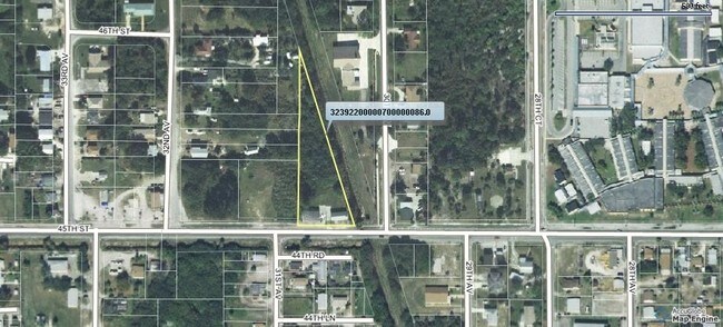
3050 45Th St, Vero Beach, FL 32967


NEARBY LISTINGS FOR SALE OR LEASE
Property Detail
3050 45Th St
32-39-22-00000-7000-00086.0
Null
Storesoffices
SEC 22 TWP 32 RNG 39 PART OF SE QTR OF SE QTR LYING W OF LATERAL H CANAL EXCEPTING THAT PART OF THE ABOVE PROPERTY DEEDED TO JOHN ERVIN MORE PART DESC AS FOLL BEG 140 FT E OF THE SE QTR OF THE SE QTR OF SAID SEC 22 TH E 100 FT TH N TO THE BANK OF LAT
AE
Indian River
12061C0241H
Florida
2025
1.14 AC
2025
Fort Pierce/Port St Lucie
050303
Other Market Areas
940 SF
Sebastian-Vero Beach-West Vero Corridor, FL
DEMOGRAPHICS near 3050 45Th St
1 mile
3 mile
5 mile
2024 Total Population
6,225
31,692
78,228
2029 Population
6,992
35,619
88,238
Pop Growth 2024-2029
+ 12.32%
+ 12.39%
+ 12.80%
Average Age
40
50
51
2024 Total Households
2,544
13,972
36,660
HH Growth 2024-2029
+ 12.26%
+ 12.10%
+ 12.58%
Median Household Inc
$32,821
$58,021
$59,899
Avg Household Size
2.40
2.10
2.00
2024 Avg HH Vehicles
1.00
2.00
2.00
Median Home Value
$139,279
$331,333
$320,031
Median Year Built
1994
1995
1987
Nearby Places
Map Layers
Map Styles
 Street
 Aerial
Transit
 Traffic
 Biking
Places
Listings with unknown addresses are not visible on the map
- Restaurants
- Banks
- Shops
- Fitness
- Groceries
Nearby Properties
Address
Land Use
TOTAL SIZE
Lot Size
Zoning
Address
Land Use
TOTAL SIZE
Lot Size
Zoning
634,259 SF
53.45 AC
MED
Address
Land Use
TOTAL SIZE
Lot Size
Zoning
571,211 SF
26.38 AC
RM-10
Address
Land Use
TOTAL SIZE
Lot Size
Zoning
21,228 SF
145.79 AC
A-1
Address
Land Use
TOTAL SIZE
Lot Size
Zoning
240,516 SF
39.71 AC
RM-8
Address
Land Use
TOTAL SIZE
Lot Size
Zoning
39,873 SF
7.61 AC
GU
Address
Land Use
TOTAL SIZE
Lot Size
Zoning
2,133 SF
772.04 AC
ALI-A1
Address
Land Use
TOTAL SIZE
Lot Size
Zoning
46,567 SF
19.61 AC
CG
Address
Land Use
TOTAL SIZE
Lot Size
Zoning
11,328 SF
4.05 AC
R-1A
Address
Land Use
TOTAL SIZE
Lot Size
Zoning
10,062 SF
3.16 AC
R-1A
Address
Land Use
TOTAL SIZE
Lot Size
Zoning
9,654 SF
0.95 AC
R-1A
Address
Land Use
TOTAL SIZE
Lot Size
Zoning
125,677 SF
2.17 AC
DTW
Address
Land Use
TOTAL SIZE
Lot Size
Zoning
8,577 SF
2.12 AC
R-1A
Address
Land Use
TOTAL SIZE
Lot Size
Zoning
49,513 SF
60.64 AC
ALI-MC
Address
Land Use
TOTAL SIZE
Lot Size
Zoning
106,904 SF
79.05 AC
M
Address
Land Use
TOTAL SIZE
Lot Size
Zoning
124.80 AC
Address
Land Use
TOTAL SIZE
Lot Size
Zoning
235,921 SF
28.80 AC
RM-8
Address
Land Use
TOTAL SIZE
Lot Size
Zoning
67,334 SF
9.63 AC
MED
Address
Land Use
TOTAL SIZE
Lot Size
Zoning
6,925 SF
2.45 AC
R-1A
Address
Land Use
TOTAL SIZE
Lot Size
Zoning
8,087 SF
1.44 AC
R-1A
Address
Land Use
TOTAL SIZE
Lot Size
Zoning
7,627 SF
4.59 AC
R-1A
Address
Land Use
TOTAL SIZE
Lot Size
Zoning
69,942 SF
10.47 AC
MED
Address
Land Use
TOTAL SIZE
Lot Size
Zoning
7,843 SF
1.73 AC
R-1A
Address
Land Use
TOTAL SIZE
Lot Size
Zoning
4,642 SF
0.56 AC
R-1A
Address
Land Use
TOTAL SIZE
Lot Size
Zoning
5,594 SF
0.81 AC
R-1A
Address
Land Use
TOTAL SIZE
Lot Size
Zoning
6,805 SF
0.86 AC
R-1A
Address
Land Use
TOTAL SIZE
Lot Size
Zoning
7,406 SF
1.12 AC
R-1A
Address
Land Use
TOTAL SIZE
Lot Size
Zoning
91,904 SF
10 AC
CG
Address
Land Use
TOTAL SIZE
Lot Size
Zoning
5,268 SF
4.62 AC
R-1
Address
Land Use
TOTAL SIZE
Lot Size
Zoning
5,756 SF
1.06 AC
R-1A
Address
Land Use
TOTAL SIZE
Lot Size
Zoning
3,540 SF
217.55 AC
ALI-A2
The World's #1 Commercial Real Estate Marketplace
Connect with us
© 2026 CoStar Group
The information above has been obtained from sources believed reliable. While we do not doubt its accuracy we have not verified it and make no guarantee, warranty or representation about it. It is your responsibility to independently confirm its accuracy and completeness. Any projections, opinions, assumptions, or estimates used are for example only and do not represent the current or future performance of the property. The value of this transaction to you depends on tax and other factors which should be evaluated by your tax, financial, and legal advisors. You and your advisors should conduct a careful, independent investigation of the property to determine to your satisfaction the suitability of the property for your needs.