Property Record
3050 Crandall Pky, Lawrence, MI 49064

Save to a Folder
{{folder.Name}}
{{folder.ListingIds.length}} Properties
{{folder.ListingIds.length}} Property
Create a New Folder
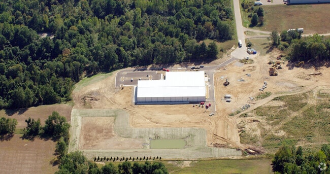
Property Detail
3050 Crandall Pky
Manufacturinglight
790-A 16-3-15 731-717 1544-155/6. 1703-163 1703-164 *** COM AT SE COR OF SEC; TH N0D03'10" W ALG E SEC L 869.70 FT TO NE COR
VILLAGE
Van Buren
B and X Area of moderate flood hazard, usually the area between the limits of the 100-year and 500-year floods.
Michigan
2025
25.38 AC
2025
Van Buren County
011300
West Michigan
60,000 SF
80-44-480-003-10
NEARBY LISTINGS FOR SALE OR LEASE
DEMOGRAPHICS near 3050 Crandall Pky
1 mile
3 mile
5 mile
2025 Total Population
503
2,794
5,772
2030 Population
506
2,825
5,838
Pop Growth 2025-2030
+ 0.60%
+ 1.11%
+ 1.14%
Average Age
38
41
42
2025 Total Households
184
1,028
2,170
HH Growth 2025-2030
+ 0.54%
+ 0.97%
+ 0.97%
Median Household Inc
$38,408
$53,390
$62,859
Avg Household Size
2.60
2.60
2.60
2025 Avg HH Vehicles
2.00
2.00
2.00
Median Home Value
$146,428
$180,325
$199,921
Median Year Built
1970
1968
1971
Nearby Places
Map Layers
Map Styles
 Street
 Aerial
Layers
 Traffic
 Biking
Places
Listings with unknown addresses are not visible on the map
- Restaurants
- Banks
- Shops
- Fitness
- Groceries
PUBLIC TRANSPORTATION
AIRPORT
Kalamazoo/Battle Creek International
Drive
Walk
Distance
Kalamazoo/Battle Creek International
39 min
28.8 mi
Freight Ports
Port Milwaukee
Drive
Walk
Distance
Port Milwaukee
243 min
204.4 mi
Nearby Properties
Address
Land Use
TOTAL SIZE
Lot Size
Zoning
Address
Land Use
TOTAL SIZE
Lot Size
Zoning
31,160 SF
3.79 AC
VILLAGE
Address
Land Use
TOTAL SIZE
Lot Size
Zoning
77,410 SF
12.25 AC
VILLAGE
Address
Land Use
TOTAL SIZE
Lot Size
Zoning
131,954 SF
13.40 AC
AG
Address
Land Use
TOTAL SIZE
Lot Size
Zoning
23,366 SF
6.34 AC
VILLAGE
Address
Land Use
TOTAL SIZE
Lot Size
Zoning
1,000 SF
5.99 AC
I-1
Address
Land Use
TOTAL SIZE
Lot Size
Zoning
28,200 SF
4.17 AC
VILLAGE
Address
Land Use
TOTAL SIZE
Lot Size
Zoning
27,000 SF
5.48 AC
VILLAGE
Address
Land Use
TOTAL SIZE
Lot Size
Zoning
68.85 AC
AG
Address
Land Use
TOTAL SIZE
Lot Size
Zoning
1,728 SF
152.11 AC
AG
Address
Land Use
TOTAL SIZE
Lot Size
Zoning
5,996 SF
15.75 AC
AG
Address
Land Use
TOTAL SIZE
Lot Size
Zoning
145.63 AC
AG
Address
Land Use
TOTAL SIZE
Lot Size
Zoning
2,520 SF
80.31 AC
Address
Land Use
TOTAL SIZE
Lot Size
Zoning
9,100 SF
1.21 AC
VILLAGE
Address
Land Use
TOTAL SIZE
Lot Size
Zoning
35,414 SF
24.41 AC
AG
Address
Land Use
TOTAL SIZE
Lot Size
Zoning
3,061 SF
39.56 AC
AG
Address
Land Use
TOTAL SIZE
Lot Size
Zoning
137.20 AC
AG
Address
Land Use
TOTAL SIZE
Lot Size
Zoning
96.88 AC
AG
Address
Land Use
TOTAL SIZE
Lot Size
Zoning
136.70 AC
AG
Address
Land Use
TOTAL SIZE
Lot Size
Zoning
7.83 AC
R-3
Address
Land Use
TOTAL SIZE
Lot Size
Zoning
3,171 SF
39.28 AC
AG
Address
Land Use
TOTAL SIZE
Lot Size
Zoning
66,296 SF
5.40 AC
AG
Address
Land Use
TOTAL SIZE
Lot Size
Zoning
2,083 SF
35.92 AC
AG
Address
Land Use
TOTAL SIZE
Lot Size
Zoning
2,527 SF
40.67 AC
AG
Address
Land Use
TOTAL SIZE
Lot Size
Zoning
720 SF
72.95 AC
VILLAGE
Address
Land Use
TOTAL SIZE
Lot Size
Zoning
1,582 SF
114.69 AC
AG
Address
Land Use
TOTAL SIZE
Lot Size
Zoning
145.50 AC
AG
Address
Land Use
TOTAL SIZE
Lot Size
Zoning
55,686 SF
11.83 AC
VILLAGE
Address
Land Use
TOTAL SIZE
Lot Size
Zoning
108.72 AC
AG
Address
Land Use
TOTAL SIZE
Lot Size
Zoning
1,716 SF
85 AC
The World's #1 Commercial Real Estate Marketplace
Connect with us
© 2026 CoStar Group
The information above has been obtained from sources believed reliable. While we do not doubt its accuracy we have not verified it and make no guarantee, warranty or representation about it. It is your responsibility to independently confirm its accuracy and completeness. Any projections, opinions, assumptions, or estimates used are for example only and do not represent the current or future performance of the property. The value of this transaction to you depends on tax and other factors which should be evaluated by your tax, financial, and legal advisors. You and your advisors should conduct a careful, independent investigation of the property to determine to your satisfaction the suitability of the property for your needs.