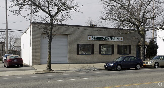
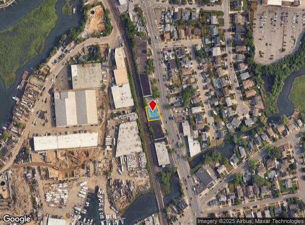
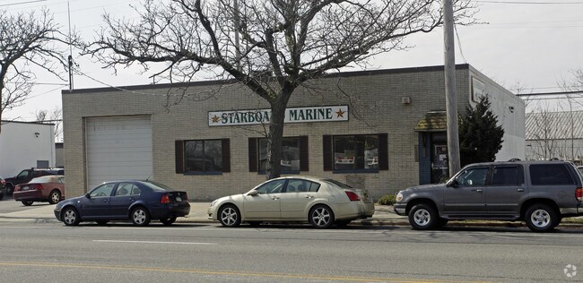
Property Record
3050 Lawson Blvd, Oceanside, NY 11572
NEARBY LISTINGS FOR SALE OR LEASE
-
-
-
-
-
-
-
-
-
-
-
-
No Photo
-
View all Oceanside listings for sale on LoopNet.com
Property Detail
3050 Lawson Blvd
2089-43-348-00-0159-0
TOWN #1 SCH DIST 011
Warehouse
Nassau
AE
New York
36059C0219G
159
2025
0.13 AC
2025
Southern Nassau
413002
Long Island (New York)
4,751 SF
Nassau County-Suffolk County, NY
DEMOGRAPHICS near 3050 Lawson Blvd
1 Mile
3 Mile
5 Mile
2024 Total Population
23,869
163,307
467,300
2029 Population
23,405
160,179
455,557
Pop Growth 2024-2029
(1.94%)
(1.92%)
(2.51%)
Average Age
42
42
41
2024 Total Households
8,484
56,193
151,226
HH Growth 2024-2029
(2.12%)
(2.05%)
(2.57%)
Median Household Inc
$112,485
$124,277
$116,982
Avg Household Size
2.70
2.80
3.00
2024 Avg HH Vehicles
2.00
2.00
2.00
Median Home Value
$632,450
$651,341
$617,245
Median Year Built
1953
1951
1953
Nearby Places
- Restaurants
- Banks
- Shops
- Fitness
- Groceries
PUBLIC TRANSPORTATION
COMMUTER RAIL
Oceanside Station (Long Beach Branch - Long Island Rail Road)
DRIVE
WALK
Distance
Oceanside Station (Long Beach Branch - Long Island Rail Road)
0 min
5 min
0.3 mi
East Rockaway Station (Long Beach Branch - Long Island Rail Road)
DRIVE
WALK
Distance
East Rockaway Station (Long Beach Branch - Long Island Rail Road)
1 min
6 min
0.3 mi
AIRPORT
John F Kennedy International
DRIVE
WALK
Distance
John F Kennedy International
18 min
10.5 mi
LaGuardia
DRIVE
WALK
Distance
LaGuardia
28 min
17.4 mi
Newark Liberty International
DRIVE
WALK
Distance
Newark Liberty International
55 min
37.2 mi
Freight Ports
NY - Red Hook Container Terminal
DRIVE
WALK
Distance
NY - Red Hook Container Terminal
38 min
21.9 mi
Nearby Properties
Address
Land Use
TOTAL SIZE
Lot Size
Zoning
Address
Land Use
TOTAL SIZE
Lot Size
Zoning
64,618 SF
8.04 AC
Address
Land Use
TOTAL SIZE
Lot Size
Zoning
Address
Land Use
TOTAL SIZE
Lot Size
Zoning
Address
Land Use
TOTAL SIZE
Lot Size
Zoning
5,800 SF
10.48 AC
Address
Land Use
TOTAL SIZE
Lot Size
Zoning
88.30 AC
Address
Land Use
TOTAL SIZE
Lot Size
Zoning
350.74 AC
Address
Land Use
TOTAL SIZE
Lot Size
Zoning
336,450 SF
139.91 AC
Address
Land Use
TOTAL SIZE
Lot Size
Zoning
30,700 SF
88.36 AC
Address
Land Use
TOTAL SIZE
Lot Size
Zoning
133.85 AC
Address
Land Use
TOTAL SIZE
Lot Size
Zoning
57,970 SF
1.69 AC
Address
Land Use
TOTAL SIZE
Lot Size
Zoning
46,404 SF
38.43 AC
Address
Land Use
TOTAL SIZE
Lot Size
Zoning
227,776 SF
16.06 AC
Address
Land Use
TOTAL SIZE
Lot Size
Zoning
115.42 AC
Address
Land Use
TOTAL SIZE
Lot Size
Zoning
151,757 SF
34.38 AC
Address
Land Use
TOTAL SIZE
Lot Size
Zoning
99,904 SF
20.17 AC
Address
Land Use
TOTAL SIZE
Lot Size
Zoning
20,670 SF
6.62 AC
Address
Land Use
TOTAL SIZE
Lot Size
Zoning
357,868 SF
24.92 AC
Address
Land Use
TOTAL SIZE
Lot Size
Zoning
66.41 AC
Address
Land Use
TOTAL SIZE
Lot Size
Zoning
140,992 SF
12.07 AC
Address
Land Use
TOTAL SIZE
Lot Size
Zoning
61.52 AC
Address
Land Use
TOTAL SIZE
Lot Size
Zoning
74,813 SF
4.56 AC
Address
Land Use
TOTAL SIZE
Lot Size
Zoning
58.86 AC
Address
Land Use
TOTAL SIZE
Lot Size
Zoning
60.30 AC
Address
Land Use
TOTAL SIZE
Lot Size
Zoning
7,172 SF
0.06 AC
R6
Address
Land Use
TOTAL SIZE
Lot Size
Zoning
484,552 SF
11.56 AC
Address
Land Use
TOTAL SIZE
Lot Size
Zoning
59,715 SF
12.81 AC
Address
Land Use
TOTAL SIZE
Lot Size
Zoning
41,612 SF
3.89 AC
Address
Land Use
TOTAL SIZE
Lot Size
Zoning
37.90 AC
Address
Land Use
TOTAL SIZE
Lot Size
Zoning
278,714 SF
3.04 AC
Address
Land Use
TOTAL SIZE
Lot Size
Zoning
45,854 SF
2.31 AC
The World's #1 Commercial Real Estate Marketplace
Connect with us
© 2025 CoStar Group
The information above has been obtained from sources believed reliable. While we do not doubt its accuracy we have not verified it and make no guarantee, warranty or representation about it. It is your responsibility to independently confirm its accuracy and completeness. Any projections, opinions, assumptions, or estimates used are for example only and do not represent the current or future performance of the property. The value of this transaction to you depends on tax and other factors which should be evaluated by your tax, financial, and legal advisors. You and your advisors should conduct a careful, independent investigation of the property to determine to your satisfaction the suitability of the property for your needs.