Property Record
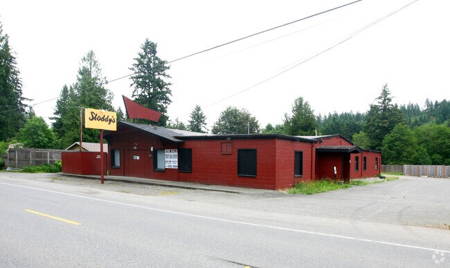
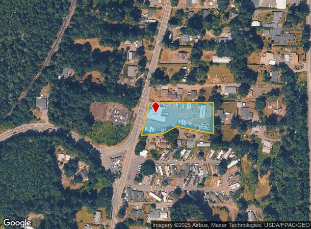
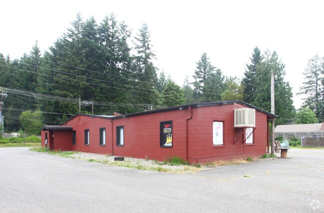
3050 Northlake Way Nw, Bremerton, WA 98312
NEARBY LISTINGS FOR SALE OR LEASE
Property Detail
3050 Northlake Way Nw
082401-2-147-2009
Second Addition To Charleston
Publicstorage
RESULTANT PARCEL 1 OF BOUNDARY LINE ADJUSTMENT RECORDED UNDER AUDITORS FILE NO. 200111200116, RECORDS OF KITSAP COUNTY, WASHINGTON, DESCRIBED AS FOLLOWS: THAT PORTION OF THE NORTHWEST QUARTER OF THE NORTHWEST QUARTER OF SECTION 8, TOWNSHIP 24 NORTH,
X
Kitsap
53035C0354F
Washington
2025
1.20 AC
2026
West Kitsap County
080900
Bremerton/Silverdale
1,632 SF
Bremerton-Silverdale, WA
DEMOGRAPHICS near 3050 Northlake Way Nw
1 Mile
3 Mile
5 Mile
2024 Total Population
4,565
22,553
93,654
2029 Population
4,583
23,002
95,083
Pop Growth 2024-2029
+ 0.39%
+ 1.99%
+ 1.53%
Average Age
36
41
39
2024 Total Households
1,696
8,980
36,296
HH Growth 2024-2029
+ 0.35%
+ 2.17%
+ 1.71%
Median Household Inc
$73,001
$69,781
$70,165
Avg Household Size
2.60
2.40
2.40
2024 Avg HH Vehicles
2.00
2.00
2.00
Median Home Value
$448,765
$470,998
$400,823
Median Year Built
1978
1979
1980
Nearby Places
Map Layers
Map Styles
 Street
 Aerial
- Restaurants
- Banks
- Shops
- Fitness
- Groceries
PUBLIC TRANSPORTATION
AIRPORT
Seattle Paine Field International
DRIVE
WALK
Distance
Seattle Paine Field International
84 min
39.5 mi
Freight Ports
Port of Seattle
DRIVE
WALK
Distance
Port of Seattle
88 min
65.9 mi
Nearby Properties
Address
Land Use
TOTAL SIZE
Lot Size
Zoning
Address
Land Use
TOTAL SIZE
Lot Size
Zoning
21,408 SF
8.26 AC
BVSAP
Address
Land Use
TOTAL SIZE
Lot Size
Zoning
138,877 SF
7.17 AC
R-10
Address
Land Use
TOTAL SIZE
Lot Size
Zoning
66,022 SF
8.28 AC
RR
Address
Land Use
TOTAL SIZE
Lot Size
Zoning
68,079 SF
2.16 AC
BVSAP
Address
Land Use
TOTAL SIZE
Lot Size
Zoning
43,944 SF
2.64 AC
FC
Address
Land Use
TOTAL SIZE
Lot Size
Zoning
45,682 SF
2.04 AC
GC
Address
Land Use
TOTAL SIZE
Lot Size
Zoning
75,225 SF
3.30 AC
R-10
Address
Land Use
TOTAL SIZE
Lot Size
Zoning
55,866 SF
8.48 AC
FC
Address
Land Use
TOTAL SIZE
Lot Size
Zoning
48,520 SF
3.76 AC
GC
Address
Land Use
TOTAL SIZE
Lot Size
Zoning
52,461 SF
5.92 AC
RR
Address
Land Use
TOTAL SIZE
Lot Size
Zoning
42,665 SF
5.55 AC
FC
Address
Land Use
TOTAL SIZE
Lot Size
Zoning
52,601 SF
6.30 AC
BVSAP
Address
Land Use
TOTAL SIZE
Lot Size
Zoning
47,064 SF
5.27 AC
GC
Address
Land Use
TOTAL SIZE
Lot Size
Zoning
74,169 SF
2.62 AC
GC
Address
Land Use
TOTAL SIZE
Lot Size
Zoning
34,792 SF
1.89 AC
R-10
Address
Land Use
TOTAL SIZE
Lot Size
Zoning
46,395 SF
2.41 AC
FC
Address
Land Use
TOTAL SIZE
Lot Size
Zoning
28,982 SF
1.90 AC
GC
Address
Land Use
TOTAL SIZE
Lot Size
Zoning
40,131 SF
4.90 AC
FC
Address
Land Use
TOTAL SIZE
Lot Size
Zoning
2.31 AC
CITY
Address
Land Use
TOTAL SIZE
Lot Size
Zoning
36,094 SF
2.84 AC
FC
Address
Land Use
TOTAL SIZE
Lot Size
Zoning
30,367 SF
4.55 AC
FC
Address
Land Use
TOTAL SIZE
Lot Size
Zoning
38,580 SF
2.44 AC
I
Address
Land Use
TOTAL SIZE
Lot Size
Zoning
42,400 SF
5.40 AC
FC
Address
Land Use
TOTAL SIZE
Lot Size
Zoning
28,000 SF
3.78 AC
FC
Address
Land Use
TOTAL SIZE
Lot Size
Zoning
7,767 SF
1 AC
UL
Address
Land Use
TOTAL SIZE
Lot Size
Zoning
37,125 SF
2.02 AC
C
Address
Land Use
TOTAL SIZE
Lot Size
Zoning
33,354 SF
3.18 AC
GC
Address
Land Use
TOTAL SIZE
Lot Size
Zoning
30,160 SF
4.63 AC
FC
Address
Land Use
TOTAL SIZE
Lot Size
Zoning
32,717 SF
3.29 AC
GC
Address
Land Use
TOTAL SIZE
Lot Size
Zoning
26,386 SF
4.68 AC
FC
The World's #1 Commercial Real Estate Marketplace
Connect with us
© 2025 CoStar Group
The information above has been obtained from sources believed reliable. While we do not doubt its accuracy we have not verified it and make no guarantee, warranty or representation about it. It is your responsibility to independently confirm its accuracy and completeness. Any projections, opinions, assumptions, or estimates used are for example only and do not represent the current or future performance of the property. The value of this transaction to you depends on tax and other factors which should be evaluated by your tax, financial, and legal advisors. You and your advisors should conduct a careful, independent investigation of the property to determine to your satisfaction the suitability of the property for your needs.