Property Record
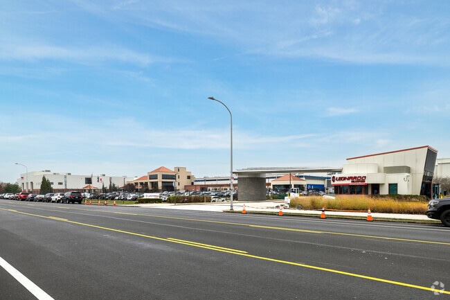
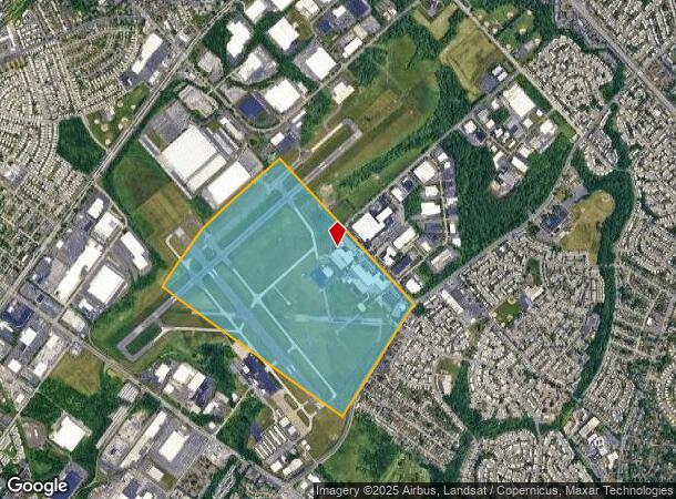
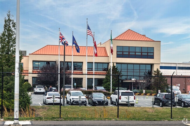
3050 Red Lion Rd, Philadelphia, PA 19114
NEARBY LISTINGS FOR SALE OR LEASE
Property Detail
3050 Red Lion Rd
884465710
139.1045 E NWC DECATUR
Industrialgeneral
Philadelphia
X
Pennsylvania
42091C0410G
6
2024
13.33 AC
2026
Greater Northeast
980300
Philadelphia
118,961 SF
Philadelphia-Camden-Wilmington, PA-NJ-DE-MD
DEMOGRAPHICS near 3050 Red Lion Rd
1 Mile
3 Mile
5 Mile
2024 Total Population
10,048
159,441
394,002
2029 Population
9,546
153,549
380,431
Pop Growth 2024-2029
(5.00%)
(3.70%)
(3.44%)
Average Age
41
42
41
2024 Total Households
4,108
62,874
148,480
HH Growth 2024-2029
(5.28%)
(4.00%)
(3.64%)
Median Household Inc
$77,268
$68,453
$66,781
Avg Household Size
2.40
2.40
2.60
2024 Avg HH Vehicles
2.00
2.00
2.00
Median Home Value
$246,811
$255,881
$251,837
Median Year Built
1965
1966
1962
Nearby Places
Map Layers
Map Styles
 Street
 Aerial
- Restaurants
- Banks
- Shops
- Fitness
- Groceries
PUBLIC TRANSPORTATION
COMMUTER RAIL
Torresdale (R7 - Southeastern Pennsylvania Transportation Authority Regional Rail (SEPTA Regional Rail))
DRIVE
WALK
Distance
Torresdale (R7 - Southeastern Pennsylvania Transportation Authority Regional Rail (SEPTA Regional Rail))
7 min
3.0 mi
Cornwells Heights (R7 - Southeastern Pennsylvania Transportation Authority Regional Rail (SEPTA Regional Rail))
DRIVE
WALK
Distance
Cornwells Heights (R7 - Southeastern Pennsylvania Transportation Authority Regional Rail (SEPTA Regional Rail))
10 min
4.6 mi
AIRPORT
Trenton Mercer
DRIVE
WALK
Distance
Trenton Mercer
32 min
19.9 mi
Philadelphia International
DRIVE
WALK
Distance
Philadelphia International
39 min
24.7 mi
Freight Ports
Port of Philadelphia
DRIVE
WALK
Distance
Port of Philadelphia
19 min
11.1 mi
Nearby Properties
Address
Land Use
TOTAL SIZE
Lot Size
Zoning
Address
Land Use
TOTAL SIZE
Lot Size
Zoning
34,350 SF
336 AC
SPPOA
Address
Land Use
TOTAL SIZE
Lot Size
Zoning
6,290 SF
177.73 AC
RSA4
Address
Land Use
TOTAL SIZE
Lot Size
Zoning
70,995 SF
5.34 AC
RSD1
Address
Land Use
TOTAL SIZE
Lot Size
Zoning
1,015,495 SF
70.51 AC
I1
Address
Land Use
TOTAL SIZE
Lot Size
Zoning
1,615,457 SF
119.41 AC
CA2
Address
Land Use
TOTAL SIZE
Lot Size
Zoning
597,188 SF
120.50 AC
RM2
Address
Land Use
TOTAL SIZE
Lot Size
Zoning
96 AC
SPPOA
Address
Land Use
TOTAL SIZE
Lot Size
Zoning
432,175 SF
16.70 AC
I2
Address
Land Use
TOTAL SIZE
Lot Size
Zoning
627,076 SF
36.89 AC
RSA1
Address
Land Use
TOTAL SIZE
Lot Size
Zoning
464,814 SF
23.90 AC
I1
Address
Land Use
TOTAL SIZE
Lot Size
Zoning
68,850 SF
16.42 AC
I1
Address
Land Use
TOTAL SIZE
Lot Size
Zoning
283,878 SF
63.36 AC
RSA3
Address
Land Use
TOTAL SIZE
Lot Size
Zoning
250,000 SF
58.32 AC
I2
Address
Land Use
TOTAL SIZE
Lot Size
Zoning
358,323 SF
27.42 AC
CA1
Address
Land Use
TOTAL SIZE
Lot Size
Zoning
2,550 SF
63.76 AC
SPPOA
Address
Land Use
TOTAL SIZE
Lot Size
Zoning
438,910 SF
24.42 AC
RSA4
Address
Land Use
TOTAL SIZE
Lot Size
Zoning
282,736 SF
21.32 AC
I1
Address
Land Use
TOTAL SIZE
Lot Size
Zoning
213,065 SF
16.12 AC
CA2
Address
Land Use
TOTAL SIZE
Lot Size
Zoning
264,852 SF
12.30 AC
CA2
Address
Land Use
TOTAL SIZE
Lot Size
Zoning
404,000 SF
1.08 AC
RM2
Address
Land Use
TOTAL SIZE
Lot Size
Zoning
233,520 SF
14.03 AC
I1
Address
Land Use
TOTAL SIZE
Lot Size
Zoning
325,000 SF
12.47 AC
RMX1
Address
Land Use
TOTAL SIZE
Lot Size
Zoning
118,001 SF
25.60 AC
I2
Address
Land Use
TOTAL SIZE
Lot Size
Zoning
459,320 SF
18 AC
RM2
Address
Land Use
TOTAL SIZE
Lot Size
Zoning
453,038 SF
34.79 AC
I1
Address
Land Use
TOTAL SIZE
Lot Size
Zoning
41.25 AC
RSA1
Address
Land Use
TOTAL SIZE
Lot Size
Zoning
447,375 SF
26.32 AC
I2
Address
Land Use
TOTAL SIZE
Lot Size
Zoning
300,700 SF
30.41 AC
I1
Address
Land Use
TOTAL SIZE
Lot Size
Zoning
43.93 AC
RSD1
Address
Land Use
TOTAL SIZE
Lot Size
Zoning
203,573 SF
9.94 AC
I1
The World's #1 Commercial Real Estate Marketplace
Connect with us
© 2025 CoStar Group
The information above has been obtained from sources believed reliable. While we do not doubt its accuracy we have not verified it and make no guarantee, warranty or representation about it. It is your responsibility to independently confirm its accuracy and completeness. Any projections, opinions, assumptions, or estimates used are for example only and do not represent the current or future performance of the property. The value of this transaction to you depends on tax and other factors which should be evaluated by your tax, financial, and legal advisors. You and your advisors should conduct a careful, independent investigation of the property to determine to your satisfaction the suitability of the property for your needs.