Property Record
3050 Tipp Rd, Theodore, AL 36582
Property Detail
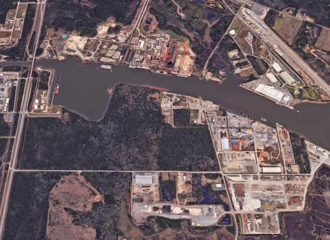
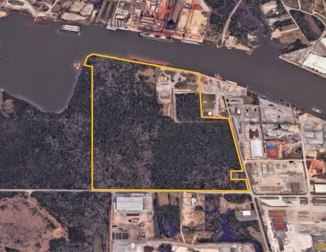
3050 Tipp Rd
Mobile, AL
BEG SE COR OF LOT 2 BLK 1 RICHARD TIPP SUBD MBK 2/35 TH RUN N 249 FT(S) TH RUN NWLY 1250 FT(S) TH RUN S 1450 FT(S) TH E 822
39-04-18-1-000-004
MOBILE
Warehouse
Alabama
AE The base floodplain where base flood elevations are provided. AE Zones are now used on new format FIRMs instead of A1-A30 Zones.
2
2025
18.37 AC
2025
Outlying Mobile County
007102
Mobile
4,000 SF
NEARBY LISTINGS FOR SALE OR LEASE
DEMOGRAPHICS near 3050 Tipp Rd
1 mile
3 mile
5 mile
2025 Total Population
67
3,883
16,869
2030 Population
67
3,926
16,898
Pop Growth 2025-2030
0.00%
+ 1.11%
+ 0.17%
Average Age
47
44
42
2025 Total Households
28
1,611
6,746
HH Growth 2025-2030
0.00%
+ 1.12%
+ 0.19%
Median Household Inc
$110,416
$73,061
$64,612
Avg Household Size
2.30
2.40
2.50
2025 Avg HH Vehicles
2.00
2.00
2.00
Median Home Value
$466,666
$281,463
$220,120
Median Year Built
1982
1985
1983
Nearby Places
Map Layers
Map Styles
 Street
 Aerial
Layers
 Traffic
 Biking
Places
Listings with unknown addresses are not visible on the map
- Restaurants
- Banks
- Shops
- Fitness
- Groceries
PUBLIC TRANSPORTATION
AIRPORT
Mobile International
Drive
Walk
Distance
Mobile International
22 min
14.0 mi
Mobile Regional
Drive
Walk
Distance
Mobile Regional
38 min
19.8 mi
Freight Ports
Port of Mobile
Drive
Walk
Distance
Port of Mobile
25 min
17.4 mi
SALE & LEASE HISTORY
LISTING DATE
SALE/LEASE

Jul 25, 2017
For Sale
Nearby Properties
Address
Land Use
TOTAL SIZE
Lot Size
Zoning
Address
Land Use
TOTAL SIZE
Lot Size
Zoning
127,658 SF
52 AC
Address
Land Use
TOTAL SIZE
Lot Size
Zoning
118,956 SF
9.90 AC
Address
Land Use
TOTAL SIZE
Lot Size
Zoning
102,400 SF
23.99 AC
Address
Land Use
TOTAL SIZE
Lot Size
Zoning
39,348 SF
100.44 AC
Address
Land Use
TOTAL SIZE
Lot Size
Zoning
82,948 SF
39.21 AC
Address
Land Use
TOTAL SIZE
Lot Size
Zoning
35,508 SF
92.85 AC
Address
Land Use
TOTAL SIZE
Lot Size
Zoning
74,374 SF
7.06 AC
Address
Land Use
TOTAL SIZE
Lot Size
Zoning
234,275 SF
40.29 AC
Address
Land Use
TOTAL SIZE
Lot Size
Zoning
132,400 SF
23 AC
Address
Land Use
TOTAL SIZE
Lot Size
Zoning
47,368 SF
45.38 AC
Address
Land Use
TOTAL SIZE
Lot Size
Zoning
15,200 SF
79.74 AC
Address
Land Use
TOTAL SIZE
Lot Size
Zoning
185.25 AC
Address
Land Use
TOTAL SIZE
Lot Size
Zoning
16,448 SF
9.30 AC
Address
Land Use
TOTAL SIZE
Lot Size
Zoning
440 SF
19.38 AC
Address
Land Use
TOTAL SIZE
Lot Size
Zoning
63,366 SF
19 AC
Address
Land Use
TOTAL SIZE
Lot Size
Zoning
150,000 SF
7.96 AC
Address
Land Use
TOTAL SIZE
Lot Size
Zoning
992 SF
46.54 AC
Address
Land Use
TOTAL SIZE
Lot Size
Zoning
82,968 SF
32.37 AC
Address
Land Use
TOTAL SIZE
Lot Size
Zoning
16,500 SF
6.98 AC
Address
Land Use
TOTAL SIZE
Lot Size
Zoning
42,240 SF
260 AC
Address
Land Use
TOTAL SIZE
Lot Size
Zoning
163.70 AC
Address
Land Use
TOTAL SIZE
Lot Size
Zoning
144,510 SF
24.18 AC
Address
Land Use
TOTAL SIZE
Lot Size
Zoning
100,000 SF
6.30 AC
Address
Land Use
TOTAL SIZE
Lot Size
Zoning
770 SF
9.16 AC
Address
Land Use
TOTAL SIZE
Lot Size
Zoning
68.03 AC
Address
Land Use
TOTAL SIZE
Lot Size
Zoning
9,000 SF
7.89 AC
Address
Land Use
TOTAL SIZE
Lot Size
Zoning
18,165 SF
13.82 AC
Address
Land Use
TOTAL SIZE
Lot Size
Zoning
395.90 AC
The World's #1 Commercial Real Estate Marketplace
Connect with us
© 2026 CoStar Group
The information above has been obtained from sources believed reliable. While we do not doubt its accuracy we have not verified it and make no guarantee, warranty or representation about it. It is your responsibility to independently confirm its accuracy and completeness. Any projections, opinions, assumptions, or estimates used are for example only and do not represent the current or future performance of the property. The value of this transaction to you depends on tax and other factors which should be evaluated by your tax, financial, and legal advisors. You and your advisors should conduct a careful, independent investigation of the property to determine to your satisfaction the suitability of the property for your needs.