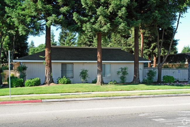
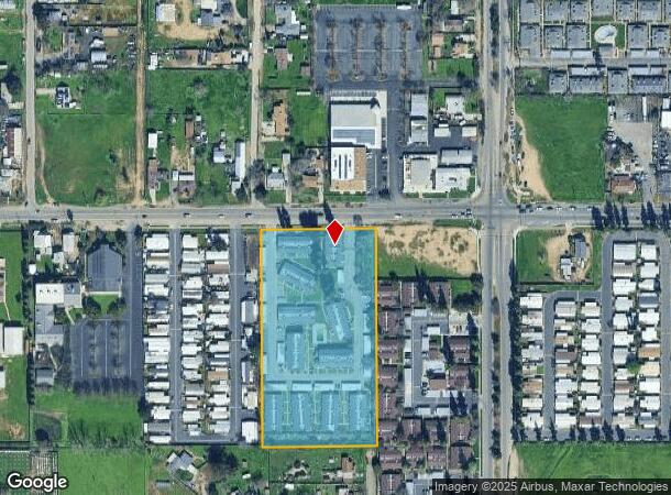
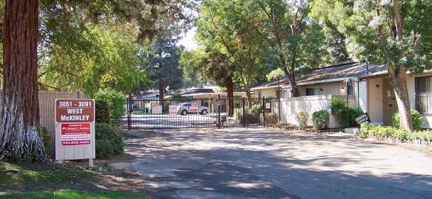
Property Record
3051 W Mckinley Ave, Fresno, CA 93722
NEARBY LISTINGS FOR SALE OR LEASE
Property Detail
3051 W Mckinley Ave
449-040-61
4.64 AC PARCEL A P/M 88-25 BK 49 PG 98
Apartment
Fresno
X
California
06019C1565H
4.64 AC
2025
West Fresno
2025
Fresno
003807
Fresno, CA
55,880 SF
DEMOGRAPHICS near 3051 W Mckinley Ave
1 Mile
3 Mile
5 Mile
2024 Total Population
12,503
117,192
284,780
2029 Population
12,725
119,175
290,537
Pop Growth 2024-2029
+ 1.78%
+ 1.69%
+ 2.02%
Average Age
33
35
35
2024 Total Households
3,811
37,656
92,057
HH Growth 2024-2029
+ 1.73%
+ 1.68%
+ 2.04%
Median Household Inc
$37,547
$53,288
$53,876
Avg Household Size
3.20
3.00
2.90
2024 Avg HH Vehicles
2.00
2.00
2.00
Median Home Value
$183,128
$263,187
$286,269
Median Year Built
1974
1969
1971
Nearby Places
Map Layers
Map Styles
 Street
 Aerial
- Restaurants
- Banks
- Shops
- Fitness
- Groceries
PUBLIC TRANSPORTATION
COMMUTER RAIL
Fresno (San Joaquins - Amtrak)
DRIVE
WALK
Distance
Fresno (San Joaquins - Amtrak)
7 min
5.0 mi
AIRPORT
Fresno Yosemite International
DRIVE
WALK
Distance
Fresno Yosemite International
14 min
7.5 mi
Freight Ports
Port of Stockton
DRIVE
WALK
Distance
Port of Stockton
147 min
124.3 mi
Nearby Properties
Address
Land Use
TOTAL SIZE
Lot Size
Zoning
Address
Land Use
TOTAL SIZE
Lot Size
Zoning
234,370 SF
23 AC
SPLIT
Address
Land Use
TOTAL SIZE
Lot Size
Zoning
232,183 SF
18.32 AC
R2A
Address
Land Use
TOTAL SIZE
Lot Size
Zoning
159,822 SF
9.67 AC
R2
Address
Land Use
TOTAL SIZE
Lot Size
Zoning
51,363 SF
3.14 AC
CG
Address
Land Use
TOTAL SIZE
Lot Size
Zoning
110,341 SF
5.45 AC
R3
Address
Land Use
TOTAL SIZE
Lot Size
Zoning
191,136 SF
12.12 AC
R2
Address
Land Use
TOTAL SIZE
Lot Size
Zoning
145,783 SF
9.22 AC
R2
Address
Land Use
TOTAL SIZE
Lot Size
Zoning
71,384 SF
6.34 AC
IL
Address
Land Use
TOTAL SIZE
Lot Size
Zoning
108,795 SF
7.32 AC
R2
Address
Land Use
TOTAL SIZE
Lot Size
Zoning
106,740 SF
63.59 AC
AE20
Address
Land Use
TOTAL SIZE
Lot Size
Zoning
32,156 SF
2.60 AC
C6
Address
Land Use
TOTAL SIZE
Lot Size
Zoning
103,088 SF
5.41 AC
R3
Address
Land Use
TOTAL SIZE
Lot Size
Zoning
84,050 SF
6.84 AC
R3
Address
Land Use
TOTAL SIZE
Lot Size
Zoning
111,104 SF
7.96 AC
R2A
Address
Land Use
TOTAL SIZE
Lot Size
Zoning
96,760 SF
11.11 AC
SPLIT
Address
Land Use
TOTAL SIZE
Lot Size
Zoning
88,345 SF
5.18 AC
R3
Address
Land Use
TOTAL SIZE
Lot Size
Zoning
95,874 SF
5.46 AC
R3
Address
Land Use
TOTAL SIZE
Lot Size
Zoning
69,428 SF
6.95 AC
C3
Address
Land Use
TOTAL SIZE
Lot Size
Zoning
52,144 SF
4.61 AC
C2
Address
Land Use
TOTAL SIZE
Lot Size
Zoning
98,542 SF
6.94 AC
R4
Address
Land Use
TOTAL SIZE
Lot Size
Zoning
83,348 SF
9.74 AC
SPLIT
Address
Land Use
TOTAL SIZE
Lot Size
Zoning
84,309 SF
3.97 AC
R3
Address
Land Use
TOTAL SIZE
Lot Size
Zoning
75,340 SF
6.15 AC
C3
Address
Land Use
TOTAL SIZE
Lot Size
Zoning
156,108 SF
8.30 AC
R3
Address
Land Use
TOTAL SIZE
Lot Size
Zoning
138,768 SF
9.55 AC
R2A
Address
Land Use
TOTAL SIZE
Lot Size
Zoning
68,933 SF
7.47 AC
CC
Address
Land Use
TOTAL SIZE
Lot Size
Zoning
74,212 SF
4.38 AC
R3
Address
Land Use
TOTAL SIZE
Lot Size
Zoning
63,456 SF
3.31 AC
R3
Address
Land Use
TOTAL SIZE
Lot Size
Zoning
86,559 SF
5.40 AC
R3
Address
Land Use
TOTAL SIZE
Lot Size
Zoning
83,931 SF
5.91 AC
SPLIT
The World's #1 Commercial Real Estate Marketplace
Connect with us
© 2026 CoStar Group
The information above has been obtained from sources believed reliable. While we do not doubt its accuracy we have not verified it and make no guarantee, warranty or representation about it. It is your responsibility to independently confirm its accuracy and completeness. Any projections, opinions, assumptions, or estimates used are for example only and do not represent the current or future performance of the property. The value of this transaction to you depends on tax and other factors which should be evaluated by your tax, financial, and legal advisors. You and your advisors should conduct a careful, independent investigation of the property to determine to your satisfaction the suitability of the property for your needs.