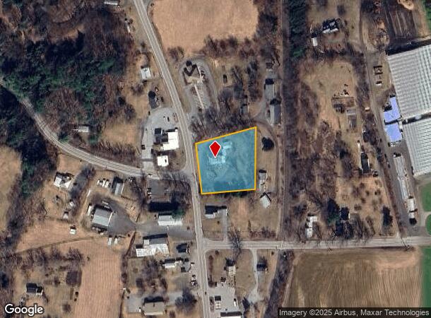
Property Record
3052 Route 5, East Thetford, VT 05043
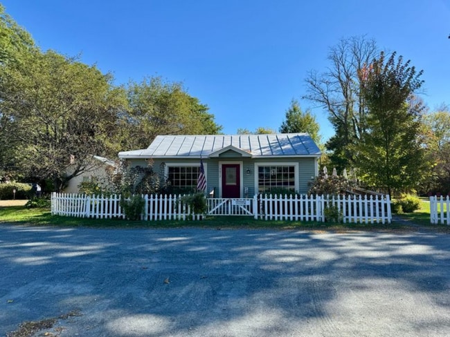
This Property Is For Sale
NEARBY LISTINGS FOR SALE OR LEASE
-
-
View all East Thetford listings for sale on LoopNet.com
Property Detail
3052 Route 5
Claremont-Lebanon, NH-VT
LAND & BUILDING
642-202-10425
Orange
Commercialofficeresidentialmixeduse
Vermont
2024
1.20 AC
2024
Vermont South Area
959600
Other Market Areas
2,868 SF
DEMOGRAPHICS near 3052 Route 5
1 Mile
3 Mile
5 Mile
2024 Total Population
339
1,934
4,506
2029 Population
323
1,872
4,422
Pop Growth 2024-2029
(4.72%)
(3.21%)
(1.86%)
Average Age
45
46
45
2024 Total Households
146
806
1,833
HH Growth 2024-2029
(4.11%)
(3.23%)
(1.85%)
Median Household Inc
$87,500
$95,143
$118,262
Avg Household Size
2.30
2.40
2.40
2024 Avg HH Vehicles
2.00
2.00
2.00
Median Home Value
$430,434
$473,076
$557,785
Median Year Built
1980
1974
1976
Nearby Places
- Restaurants
- Banks
- Shops
- Fitness
- Groceries
Nearby Properties
Address
Land Use
TOTAL SIZE
Lot Size
Zoning
Address
Land Use
TOTAL SIZE
Lot Size
Zoning
294.61 AC
HD
Address
Land Use
TOTAL SIZE
Lot Size
Zoning
1.97 AC
CB
Address
Land Use
TOTAL SIZE
Lot Size
Zoning
Address
Land Use
TOTAL SIZE
Lot Size
Zoning
35,876 SF
6.80 AC
LCD
Address
Land Use
TOTAL SIZE
Lot Size
Zoning
9,335 SF
BD
Address
Land Use
TOTAL SIZE
Lot Size
Zoning
13,094 SF
136 AC
Address
Land Use
TOTAL SIZE
Lot Size
Zoning
16,880 SF
12.60 AC
CB
Address
Land Use
TOTAL SIZE
Lot Size
Zoning
53.91 AC
RR
Address
Land Use
TOTAL SIZE
Lot Size
Zoning
14,114 SF
5.40 AC
LCD
Address
Land Use
TOTAL SIZE
Lot Size
Zoning
900 SF
10.84 AC
VR
Address
Land Use
TOTAL SIZE
Lot Size
Zoning
2,128 SF
3.20 AC
RD
Address
Land Use
TOTAL SIZE
Lot Size
Zoning
3,964 SF
42.50 AC
RD
Address
Land Use
TOTAL SIZE
Lot Size
Zoning
0.66 AC
HD
Address
Land Use
TOTAL SIZE
Lot Size
Zoning
1,522 SF
3.11 AC
LCD
Address
Land Use
TOTAL SIZE
Lot Size
Zoning
13,115 SF
0.96 AC
LCD
Address
Land Use
TOTAL SIZE
Lot Size
Zoning
9,928 SF
0.33 AC
LCD
Address
Land Use
TOTAL SIZE
Lot Size
Zoning
11,327 SF
1.40 AC
LCD
Address
Land Use
TOTAL SIZE
Lot Size
Zoning
0.50 AC
VR
Address
Land Use
TOTAL SIZE
Lot Size
Zoning
3,613 SF
85.15 AC
RD
Address
Land Use
TOTAL SIZE
Lot Size
Zoning
5,253 SF
RR
Address
Land Use
TOTAL SIZE
Lot Size
Zoning
2,534 SF
17 AC
RR
Address
Land Use
TOTAL SIZE
Lot Size
Zoning
44 AC
RD
Address
Land Use
TOTAL SIZE
Lot Size
Zoning
4,762 SF
236.80 AC
RD
Address
Land Use
TOTAL SIZE
Lot Size
Zoning
2,788 SF
29 AC
RD
Address
Land Use
TOTAL SIZE
Lot Size
Zoning
4,299 SF
43.79 AC
RD
Address
Land Use
TOTAL SIZE
Lot Size
Zoning
2.44 AC
RR
Address
Land Use
TOTAL SIZE
Lot Size
Zoning
6,426 SF
1.94 AC
CB
Address
Land Use
TOTAL SIZE
Lot Size
Zoning
1,599 SF
0.92 AC
RD
Address
Land Use
TOTAL SIZE
Lot Size
Zoning
7,281 SF
8.97 AC
RD
Address
Land Use
TOTAL SIZE
Lot Size
Zoning
6,020 SF
5.90 AC
RD
The World's #1 Commercial Real Estate Marketplace
Connect with us
© 2025 CoStar Group
The information above has been obtained from sources believed reliable. While we do not doubt its accuracy we have not verified it and make no guarantee, warranty or representation about it. It is your responsibility to independently confirm its accuracy and completeness. Any projections, opinions, assumptions, or estimates used are for example only and do not represent the current or future performance of the property. The value of this transaction to you depends on tax and other factors which should be evaluated by your tax, financial, and legal advisors. You and your advisors should conduct a careful, independent investigation of the property to determine to your satisfaction the suitability of the property for your needs.