Property Record
3053 Highway 367 N, Austin, AR 72007


Save to a Folder
{{folder.Name}}
{{folder.ListingIds.length}} Properties
{{folder.ListingIds.length}} Property
Create a New Folder
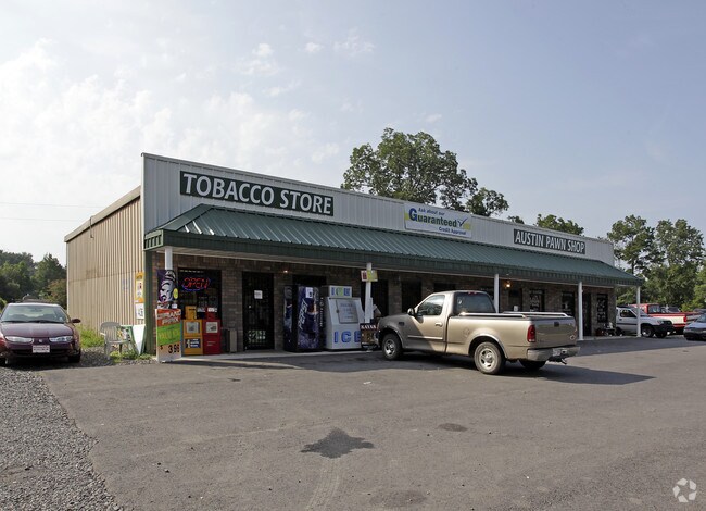
Property Detail
3053 Highway 367 N
Little Rock-North Little Rock-Conway, AR
LOTS 10-12 OF 56 ( LESS S 4FT) & 16FT ALLEY PT MURREL ST ADJ TO LOTS 7, 8, & 9 OF BLK 40
710-05611-000
LONOKE
Publicstorage
Arkansas
AE The base floodplain where base flood elevations are provided. AE Zones are now used on new format FIRMs instead of A1-A30 Zones.
7-12
2023
0.70 AC
2025
Lonoke County
020202
Little Rock/N Little Rock
7,200 SF
NEARBY LISTINGS FOR SALE OR LEASE
-
-
View all Austin listings for sale on LoopNet.com
DEMOGRAPHICS near 3053 Highway 367 N
1 mile
3 mile
5 mile
2025 Total Population
2,061
21,423
43,652
2030 Population
2,117
21,999
44,693
Pop Growth 2025-2030
+ 2.72%
+ 2.69%
+ 2.38%
Average Age
37
38
38
2025 Total Households
741
7,958
16,149
HH Growth 2025-2030
+ 2.83%
+ 2.75%
+ 2.45%
Median Household Inc
$90,075
$81,383
$82,366
Avg Household Size
2.70
2.60
2.70
2025 Avg HH Vehicles
2.00
2.00
2.00
Median Home Value
$227,213
$191,193
$199,032
Median Year Built
2005
2000
2000
Nearby Places
Map Layers
Map Styles
 Street
 Aerial
Layers
 Traffic
 Biking
Places
Listings with unknown addresses are not visible on the map
- Restaurants
- Banks
- Shops
- Fitness
- Groceries
PUBLIC TRANSPORTATION
AIRPORT
Bill and Hillary Clinton Ntl/Adams Field
Drive
Walk
Distance
Bill and Hillary Clinton Ntl/Adams Field
34 min
28.5 mi
Nearby Properties
Address
Land Use
TOTAL SIZE
Lot Size
Zoning
Address
Land Use
TOTAL SIZE
Lot Size
Zoning
44,884 SF
9.65 AC
Address
Land Use
TOTAL SIZE
Lot Size
Zoning
23,603 SF
0.70 AC
Address
Land Use
TOTAL SIZE
Lot Size
Zoning
141,490 SF
9.97 AC
Address
Land Use
TOTAL SIZE
Lot Size
Zoning
13,302 SF
0.71 AC
Address
Land Use
TOTAL SIZE
Lot Size
Zoning
50,550 SF
8.98 AC
Address
Land Use
TOTAL SIZE
Lot Size
Zoning
139,126 SF
10 AC
Address
Land Use
TOTAL SIZE
Lot Size
Zoning
51,992 SF
2.82 AC
Address
Land Use
TOTAL SIZE
Lot Size
Zoning
67,672 SF
5.23 AC
Address
Land Use
TOTAL SIZE
Lot Size
Zoning
91,224 SF
8.39 AC
Address
Land Use
TOTAL SIZE
Lot Size
Zoning
32,438 SF
7.40 AC
Address
Land Use
TOTAL SIZE
Lot Size
Zoning
9,750 SF
1.62 AC
Address
Land Use
TOTAL SIZE
Lot Size
Zoning
41,864 SF
5.22 AC
Address
Land Use
TOTAL SIZE
Lot Size
Zoning
16,426 SF
3.21 AC
Address
Land Use
TOTAL SIZE
Lot Size
Zoning
83,775 SF
2.04 AC
Address
Land Use
TOTAL SIZE
Lot Size
Zoning
39,800 SF
9.94 AC
Address
Land Use
TOTAL SIZE
Lot Size
Zoning
15,900 SF
2.11 AC
Address
Land Use
TOTAL SIZE
Lot Size
Zoning
11,683 SF
0.58 AC
Address
Land Use
TOTAL SIZE
Lot Size
Zoning
8,450 SF
0.62 AC
Address
Land Use
TOTAL SIZE
Lot Size
Zoning
55,587 SF
3 AC
Address
Land Use
TOTAL SIZE
Lot Size
Zoning
31,919 SF
4.15 AC
Address
Land Use
TOTAL SIZE
Lot Size
Zoning
8,700 SF
0.44 AC
Address
Land Use
TOTAL SIZE
Lot Size
Zoning
7,288 SF
3.13 AC
Address
Land Use
TOTAL SIZE
Lot Size
Zoning
23,784 SF
1.01 AC
Address
Land Use
TOTAL SIZE
Lot Size
Zoning
23,874 SF
3.01 AC
Address
Land Use
TOTAL SIZE
Lot Size
Zoning
17,416 SF
2.23 AC
Address
Land Use
TOTAL SIZE
Lot Size
Zoning
26,144 SF
10.09 AC
Address
Land Use
TOTAL SIZE
Lot Size
Zoning
38,223 SF
3.40 AC
Address
Land Use
TOTAL SIZE
Lot Size
Zoning
6,836 SF
1.84 AC
Address
Land Use
TOTAL SIZE
Lot Size
Zoning
4,800 SF
0.12 AC
Address
Land Use
TOTAL SIZE
Lot Size
Zoning
13,995 SF
1.77 AC
The World's #1 Commercial Real Estate Marketplace
Connect with us
© 2026 CoStar Group
The information above has been obtained from sources believed reliable. While we do not doubt its accuracy we have not verified it and make no guarantee, warranty or representation about it. It is your responsibility to independently confirm its accuracy and completeness. Any projections, opinions, assumptions, or estimates used are for example only and do not represent the current or future performance of the property. The value of this transaction to you depends on tax and other factors which should be evaluated by your tax, financial, and legal advisors. You and your advisors should conduct a careful, independent investigation of the property to determine to your satisfaction the suitability of the property for your needs.