Property Record
3055 Shasta View Dr, Redding, CA 96002
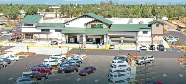

Property Detail
3055 Shasta View Dr
Redding, CA
SHASTA
110-020-089-000
California
Supermarket
3.83 AC
2024
Redding/Chico
2025
Other Market Areas
NEARBY LISTINGS FOR SALE OR LEASE
DEMOGRAPHICS near 3055 Shasta View Dr
1 mile
3 mile
5 mile
2025 Total Population
10,401
45,858
90,879
2030 Population
10,371
45,914
91,056
Pop Growth 2025-2030
(0.29%)
+ 0.12%
+ 0.19%
Average Age
38
40
41
2025 Total Households
3,796
17,578
36,390
HH Growth 2025-2030
(0.29%)
+ 0.11%
+ 0.21%
Median Household Inc
$84,381
$82,810
$75,816
Avg Household Size
2.70
2.50
2.40
2025 Avg HH Vehicles
2.00
2.00
2.00
Median Home Value
$355,928
$380,495
$379,165
Median Year Built
1980
1982
1982
Nearby Places
Map Layers
Map Styles
 Street
 Aerial
Layers
 Traffic
 Biking
Places
Listings with unknown addresses are not visible on the map
- Restaurants
- Banks
- Shops
- Fitness
- Groceries
PUBLIC TRANSPORTATION
COMMUTER RAIL
Redding Amtrak (Coast Starlight - Amtrak)
Drive
Walk
Distance
Redding Amtrak (Coast Starlight - Amtrak)
8 min
5.2 mi
AIRPORT
Redding Regional
Drive
Walk
Distance
Redding Regional
8 min
5.0 mi
Freight Ports
Port of Richmond
Drive
Walk
Distance
Port of Richmond
232 min
203.7 mi
SALE & LEASE HISTORY
LISTING DATE
SALE/LEASE

Aug 13, 2025
For Sale
Nearby Properties
Address
Land Use
TOTAL SIZE
Lot Size
Zoning
Address
Land Use
TOTAL SIZE
Lot Size
Zoning
151,773 SF
17.64 AC
Address
Land Use
TOTAL SIZE
Lot Size
Zoning
1,016 SF
14.35 AC
Address
Land Use
TOTAL SIZE
Lot Size
Zoning
140.36 AC
Address
Land Use
TOTAL SIZE
Lot Size
Zoning
8.22 AC
Address
Land Use
TOTAL SIZE
Lot Size
Zoning
223,579 SF
19.65 AC
Address
Land Use
TOTAL SIZE
Lot Size
Zoning
89,098 SF
7.24 AC
Address
Land Use
TOTAL SIZE
Lot Size
Zoning
21,089 SF
7 AC
Address
Land Use
TOTAL SIZE
Lot Size
Zoning
47,062 SF
4.80 AC
Address
Land Use
TOTAL SIZE
Lot Size
Zoning
73,000 SF
4.40 AC
Address
Land Use
TOTAL SIZE
Lot Size
Zoning
143,164 SF
13.90 AC
Address
Land Use
TOTAL SIZE
Lot Size
Zoning
19,572 SF
5.94 AC
Address
Land Use
TOTAL SIZE
Lot Size
Zoning
81,800 SF
14.81 AC
Address
Land Use
TOTAL SIZE
Lot Size
Zoning
5.44 AC
Address
Land Use
TOTAL SIZE
Lot Size
Zoning
50,251 SF
4.06 AC
Address
Land Use
TOTAL SIZE
Lot Size
Zoning
92,699 SF
5.91 AC
Address
Land Use
TOTAL SIZE
Lot Size
Zoning
10.27 AC
Address
Land Use
TOTAL SIZE
Lot Size
Zoning
11.90 AC
Address
Land Use
TOTAL SIZE
Lot Size
Zoning
95,645 SF
9.55 AC
Address
Land Use
TOTAL SIZE
Lot Size
Zoning
2.42 AC
Address
Land Use
TOTAL SIZE
Lot Size
Zoning
101,683 SF
8.48 AC
Address
Land Use
TOTAL SIZE
Lot Size
Zoning
83,276 SF
3.02 AC
Address
Land Use
TOTAL SIZE
Lot Size
Zoning
16,320 SF
3.76 AC
Address
Land Use
TOTAL SIZE
Lot Size
Zoning
55,351 SF
5.65 AC
Address
Land Use
TOTAL SIZE
Lot Size
Zoning
46,705 SF
2 AC
Address
Land Use
TOTAL SIZE
Lot Size
Zoning
11.80 AC
Address
Land Use
TOTAL SIZE
Lot Size
Zoning
4.10 AC
Address
Land Use
TOTAL SIZE
Lot Size
Zoning
10.28 AC
Address
Land Use
TOTAL SIZE
Lot Size
Zoning
125,402 SF
20.61 AC
Address
Land Use
TOTAL SIZE
Lot Size
Zoning
66,420 SF
4.80 AC
Address
Land Use
TOTAL SIZE
Lot Size
Zoning
2.39 AC
The World's #1 Commercial Real Estate Marketplace
Connect with us
© 2026 CoStar Group
The information above has been obtained from sources believed reliable. While we do not doubt its accuracy we have not verified it and make no guarantee, warranty or representation about it. It is your responsibility to independently confirm its accuracy and completeness. Any projections, opinions, assumptions, or estimates used are for example only and do not represent the current or future performance of the property. The value of this transaction to you depends on tax and other factors which should be evaluated by your tax, financial, and legal advisors. You and your advisors should conduct a careful, independent investigation of the property to determine to your satisfaction the suitability of the property for your needs.