Property Record
30561 Old Us 20, Elkhart, IN 46514

NEARBY LISTINGS FOR SALE OR LEASE
-
-
No Photo
-
View all Elkhart listings for sale on LoopNet.com
Property Detail
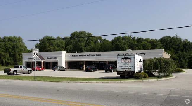
30561 Old Us 20
Elkhart-Goshen, IN
Ahnzu Properties Industrial Sub
20-05-03-176-033.000-005
AHNZU PROPERTIES INDUSTRIAL SUB LOT 1 (TIF 122)
Regionalshoppingcenterormallwithanchorstore
Elkhart
X
Indiana
18039C0108D
1
2024
1.72 AC
2025
Outlying Elkhart County
001501
South Bend/Mishawaka
9,900 SF
DEMOGRAPHICS near 30561 Old Us 20
1 Mile
3 Mile
5 Mile
2024 Total Population
3,052
31,072
87,097
2029 Population
3,042
30,858
86,918
Pop Growth 2024-2029
(0.33%)
(0.69%)
(0.21%)
Average Age
39
39
38
2024 Total Households
1,110
11,280
32,148
HH Growth 2024-2029
(0.27%)
(0.78%)
(0.17%)
Median Household Inc
$66,267
$70,042
$59,229
Avg Household Size
2.70
2.70
2.60
2024 Avg HH Vehicles
2.00
2.00
2.00
Median Home Value
$174,802
$174,155
$171,057
Median Year Built
1980
1977
1973
Nearby Places
Map Layers
Map Styles
 Street
 Aerial
- Restaurants
- Banks
- Shops
- Fitness
- Groceries
PUBLIC TRANSPORTATION
COMMUTER RAIL
Elkhart Amtrak Station (Capitol Limited - Amtrak, Lake Shore Limited - Amtrak)
DRIVE
WALK
Distance
Elkhart Amtrak Station (Capitol Limited - Amtrak, Lake Shore Limited - Amtrak)
8 min
4.6 mi
AIRPORT
South Bend International
DRIVE
WALK
Distance
South Bend International
35 min
16.5 mi
Freight Ports
Port Milwaukee
DRIVE
WALK
Distance
Port Milwaukee
230 min
191.3 mi
Nearby Properties
Address
Land Use
TOTAL SIZE
Lot Size
Zoning
Address
Land Use
TOTAL SIZE
Lot Size
Zoning
300,000 SF
68.80 AC
ZO01
Address
Land Use
TOTAL SIZE
Lot Size
Zoning
377,169 SF
23.85 AC
ZO01
Address
Land Use
TOTAL SIZE
Lot Size
Zoning
36,851 SF
22.72 AC
Address
Land Use
TOTAL SIZE
Lot Size
Zoning
83,856 SF
54.56 AC
ZO01
Address
Land Use
TOTAL SIZE
Lot Size
Zoning
189,262 SF
23.71 AC
ZO01
Address
Land Use
TOTAL SIZE
Lot Size
Zoning
277,504 SF
18.61 AC
ZO01
Address
Land Use
TOTAL SIZE
Lot Size
Zoning
52,155 SF
45.11 AC
ZO01
Address
Land Use
TOTAL SIZE
Lot Size
Zoning
316,658 SF
27.46 AC
Address
Land Use
TOTAL SIZE
Lot Size
Zoning
81,452 SF
33.51 AC
ZO01
Address
Land Use
TOTAL SIZE
Lot Size
Zoning
144,000 SF
18.31 AC
ZO01
Address
Land Use
TOTAL SIZE
Lot Size
Zoning
188,176 SF
12.75 AC
ZO01
Address
Land Use
TOTAL SIZE
Lot Size
Zoning
86,252 SF
9.13 AC
ZO01
Address
Land Use
TOTAL SIZE
Lot Size
Zoning
51,620 SF
30.21 AC
ZO01
Address
Land Use
TOTAL SIZE
Lot Size
Zoning
120,320 SF
8.40 AC
Address
Land Use
TOTAL SIZE
Lot Size
Zoning
181,986 SF
30.91 AC
ZO01
Address
Land Use
TOTAL SIZE
Lot Size
Zoning
115,990 SF
11.91 AC
Address
Land Use
TOTAL SIZE
Lot Size
Zoning
61,877 SF
13.54 AC
Address
Land Use
TOTAL SIZE
Lot Size
Zoning
81,185 SF
23.42 AC
Address
Land Use
TOTAL SIZE
Lot Size
Zoning
159,677 SF
12.76 AC
Address
Land Use
TOTAL SIZE
Lot Size
Zoning
106,084 SF
9.11 AC
ZO01
Address
Land Use
TOTAL SIZE
Lot Size
Zoning
89,650 SF
7.58 AC
Address
Land Use
TOTAL SIZE
Lot Size
Zoning
120,535 SF
14 AC
Address
Land Use
TOTAL SIZE
Lot Size
Zoning
95,250 SF
7 AC
ZO01
Address
Land Use
TOTAL SIZE
Lot Size
Zoning
136,400 SF
6.48 AC
M-1
Address
Land Use
TOTAL SIZE
Lot Size
Zoning
68,750 SF
33.38 AC
ZO01
Address
Land Use
TOTAL SIZE
Lot Size
Zoning
37,735 SF
8.25 AC
Address
Land Use
TOTAL SIZE
Lot Size
Zoning
46,080 SF
2.64 AC
Address
Land Use
TOTAL SIZE
Lot Size
Zoning
49,293 SF
87 SF
Address
Land Use
TOTAL SIZE
Lot Size
Zoning
50,250 SF
16.70 AC
ZO01
Address
Land Use
TOTAL SIZE
Lot Size
Zoning
45,668 SF
5.81 AC
ZO01
The World's #1 Commercial Real Estate Marketplace
Connect with us
© 2026 CoStar Group
The information above has been obtained from sources believed reliable. While we do not doubt its accuracy we have not verified it and make no guarantee, warranty or representation about it. It is your responsibility to independently confirm its accuracy and completeness. Any projections, opinions, assumptions, or estimates used are for example only and do not represent the current or future performance of the property. The value of this transaction to you depends on tax and other factors which should be evaluated by your tax, financial, and legal advisors. You and your advisors should conduct a careful, independent investigation of the property to determine to your satisfaction the suitability of the property for your needs.