Property Record
3059 Highway 71 E, Del Valle, TX 78617
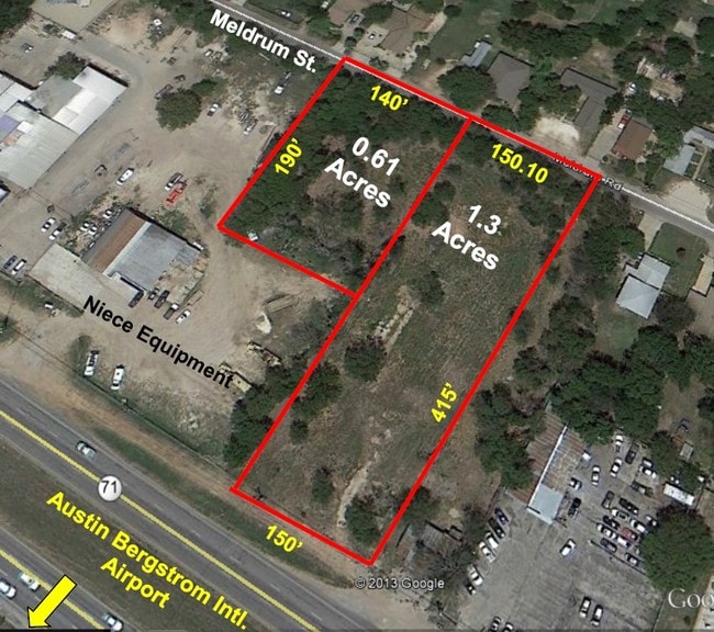

Property Detail
3059 Highway 71 E
Austin-Round Rock-San Marcos, TX
ABS 24 DELVALLE S ACR 1.2922
292645
TRAVIS
Vacantlandnec
Texas
B and X Area of moderate flood hazard, usually the area between the limits of the 100-year and 500-year floods.
1.29 AC
2025
Southeast
2025
Austin
002310
NEARBY LISTINGS FOR SALE OR LEASE
DEMOGRAPHICS near 3059 Highway 71 E
1 mile
3 mile
5 mile
2025 Total Population
2,103
15,615
73,842
2030 Population
2,305
16,759
78,893
Pop Growth 2025-2030
+ 9.61%
+ 7.33%
+ 6.84%
Average Age
36
35
34
2025 Total Households
721
4,567
26,129
HH Growth 2025-2030
+ 10.40%
+ 8.08%
+ 7.53%
Median Household Inc
$74,090
$69,914
$82,979
Avg Household Size
2.90
3.20
2.70
2025 Avg HH Vehicles
3.00
2.00
2.00
Median Home Value
$267,804
$281,912
$363,052
Median Year Built
2010
2009
2008
Nearby Places
Map Layers
Map Styles
 Street
 Aerial
Transit
 Traffic
 Biking
Places
Listings with unknown addresses are not visible on the map
- Restaurants
- Banks
- Shops
- Fitness
- Groceries
PUBLIC TRANSPORTATION
COMMUTER RAIL
Austin (Texas Eagle - Amtrak)
Drive
Walk
Distance
Austin (Texas Eagle - Amtrak)
15 min
9.1 mi
AIRPORT
Austin-Bergstrom International
Drive
Walk
Distance
Austin-Bergstrom International
17 min
6.6 mi
Freight Ports
Calhoun Port
Drive
Walk
Distance
Calhoun Port
179 min
151.0 mi
SALE & LEASE HISTORY
LISTING DATE
SALE/LEASE

Sep 24, 2016
For Sale
Aug 10, 2020
For Sale
Nearby Properties
Address
Land Use
TOTAL SIZE
Lot Size
Zoning
Address
Land Use
TOTAL SIZE
Lot Size
Zoning
942.08 AC
Address
Land Use
TOTAL SIZE
Lot Size
Zoning
801,840 SF
63.90 AC
Address
Land Use
TOTAL SIZE
Lot Size
Zoning
255,483 SF
35 AC
Address
Land Use
TOTAL SIZE
Lot Size
Zoning
354,664 SF
16.80 AC
Address
Land Use
TOTAL SIZE
Lot Size
Zoning
206,608 SF
10.61 AC
Address
Land Use
TOTAL SIZE
Lot Size
Zoning
179,800 SF
442.94 AC
Address
Land Use
TOTAL SIZE
Lot Size
Zoning
241,725 SF
16.76 AC
Address
Land Use
TOTAL SIZE
Lot Size
Zoning
247,500 SF
15.78 AC
Address
Land Use
TOTAL SIZE
Lot Size
Zoning
237,600 SF
10.10 AC
Address
Land Use
TOTAL SIZE
Lot Size
Zoning
7,366 SF
88.64 AC
Address
Land Use
TOTAL SIZE
Lot Size
Zoning
295,980 SF
47.98 AC
Address
Land Use
TOTAL SIZE
Lot Size
Zoning
4,843 SF
150.70 AC
Address
Land Use
TOTAL SIZE
Lot Size
Zoning
139,750 SF
50.37 AC
Address
Land Use
TOTAL SIZE
Lot Size
Zoning
122,836 SF
10.79 AC
Address
Land Use
TOTAL SIZE
Lot Size
Zoning
231,888 SF
11.86 AC
Address
Land Use
TOTAL SIZE
Lot Size
Zoning
138,850 SF
14.09 AC
Address
Land Use
TOTAL SIZE
Lot Size
Zoning
4,098 SF
201.61 AC
Address
Land Use
TOTAL SIZE
Lot Size
Zoning
183,082 SF
Address
Land Use
TOTAL SIZE
Lot Size
Zoning
112,101 SF
5.99 AC
Address
Land Use
TOTAL SIZE
Lot Size
Zoning
2,366 SF
19.82 AC
Address
Land Use
TOTAL SIZE
Lot Size
Zoning
94,952 SF
11.60 AC
Address
Land Use
TOTAL SIZE
Lot Size
Zoning
143,250 SF
17.44 AC
Address
Land Use
TOTAL SIZE
Lot Size
Zoning
79,656 SF
3.28 AC
Address
Land Use
TOTAL SIZE
Lot Size
Zoning
104,420 SF
23.55 AC
Address
Land Use
TOTAL SIZE
Lot Size
Zoning
80,562 SF
3.40 AC
Address
Land Use
TOTAL SIZE
Lot Size
Zoning
93,330 SF
3.34 AC
Address
Land Use
TOTAL SIZE
Lot Size
Zoning
6,032 SF
207.65 AC
Address
Land Use
TOTAL SIZE
Lot Size
Zoning
116.40 AC
Address
Land Use
TOTAL SIZE
Lot Size
Zoning
2,359 SF
Address
Land Use
TOTAL SIZE
Lot Size
Zoning
149.67 AC
The World's #1 Commercial Real Estate Marketplace
Connect with us
© 2026 CoStar Group
The information above has been obtained from sources believed reliable. While we do not doubt its accuracy we have not verified it and make no guarantee, warranty or representation about it. It is your responsibility to independently confirm its accuracy and completeness. Any projections, opinions, assumptions, or estimates used are for example only and do not represent the current or future performance of the property. The value of this transaction to you depends on tax and other factors which should be evaluated by your tax, financial, and legal advisors. You and your advisors should conduct a careful, independent investigation of the property to determine to your satisfaction the suitability of the property for your needs.