Property Record
306 Hackensack St, Wood Ridge, NJ 07075
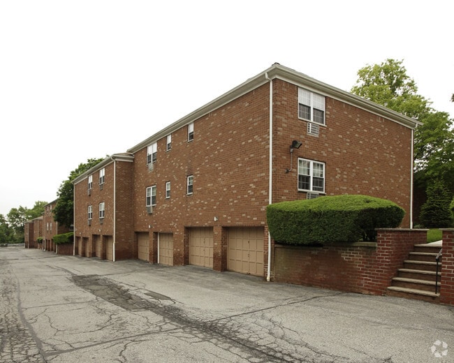

Property Detail
306 Hackensack St
New York-Jersey City-White Plains, NY-NJ
283 X 700
69-00328-0000-00013
Bergen
Apartment
New Jersey
R3
13
B and X Area of moderate flood hazard, usually the area between the limits of the 100-year and 500-year floods.
4.55 AC
2024
Greater Bergen County
2025
Northern New Jersey
060001
NEARBY LISTINGS FOR SALE OR LEASE
DEMOGRAPHICS near 306 Hackensack St
1 mile
3 mile
5 mile
2025 Total Population
21,574
219,280
586,868
2030 Population
22,204
222,368
597,997
Pop Growth 2025-2030
+ 2.92%
+ 1.41%
+ 1.90%
Average Age
41
39
40
2025 Total Households
8,304
79,282
212,840
HH Growth 2025-2030
+ 2.93%
+ 1.46%
+ 2.01%
Median Household Inc
$117,699
$81,506
$92,143
Avg Household Size
2.60
2.70
2.70
2025 Avg HH Vehicles
2.00
1.00
2.00
Median Home Value
$566,801
$494,109
$491,553
Median Year Built
1956
1955
1955
Nearby Places
Map Layers
Map Styles
 Street
 Aerial
Layers
 Traffic
 Biking
Places
Listings with unknown addresses are not visible on the map
- Restaurants
- Banks
- Shops
- Fitness
- Groceries
PUBLIC TRANSPORTATION
COMMUTER RAIL
Wood Ridge (Pascack Valley Line - NJ Transit Commuter Rail (NJ Transit))
Drive
Walk
Distance
Wood Ridge (Pascack Valley Line - NJ Transit Commuter Rail (NJ Transit))
5 min
9 min
0.5 mi
Wesmont (Main/Bergen County Line - NJ TRANSIT RAIL, Port Jervis Line - NJ TRANSIT RAIL)
Drive
Walk
Distance
Wesmont (Main/Bergen County Line - NJ TRANSIT RAIL, Port Jervis Line - NJ TRANSIT RAIL)
5 min
1.3 mi
AIRPORT
Newark Liberty International
Drive
Walk
Distance
Newark Liberty International
19 min
14.2 mi
LaGuardia
Drive
Walk
Distance
LaGuardia
33 min
20.2 mi
John F Kennedy International
Drive
Walk
Distance
John F Kennedy International
44 min
31.3 mi
Freight Ports
Port Newark Container Terminal
Drive
Walk
Distance
Port Newark Container Terminal
26 min
15.9 mi
Nearby Properties
Address
Land Use
TOTAL SIZE
Lot Size
Zoning
Address
Land Use
TOTAL SIZE
Lot Size
Zoning
Address
Land Use
TOTAL SIZE
Lot Size
Zoning
488,779 SF
7.55 AC
HCS
Address
Land Use
TOTAL SIZE
Lot Size
Zoning
Address
Land Use
TOTAL SIZE
Lot Size
Zoning
4,014 SF
21 AC
Address
Land Use
TOTAL SIZE
Lot Size
Zoning
612 AC
SEA
Address
Land Use
TOTAL SIZE
Lot Size
Zoning
335.71 AC
AF
Address
Land Use
TOTAL SIZE
Lot Size
Zoning
Address
Land Use
TOTAL SIZE
Lot Size
Zoning
Address
Land Use
TOTAL SIZE
Lot Size
Zoning
Address
Land Use
TOTAL SIZE
Lot Size
Zoning
Address
Land Use
TOTAL SIZE
Lot Size
Zoning
Address
Land Use
TOTAL SIZE
Lot Size
Zoning
Address
Land Use
TOTAL SIZE
Lot Size
Zoning
9.57 AC
I2
Address
Land Use
TOTAL SIZE
Lot Size
Zoning
4.37 AC
HCS
Address
Land Use
TOTAL SIZE
Lot Size
Zoning
68.93 AC
Address
Land Use
TOTAL SIZE
Lot Size
Zoning
281,720 SF
3.93 AC
R-3
Address
Land Use
TOTAL SIZE
Lot Size
Zoning
7.10 AC
R-3
Address
Land Use
TOTAL SIZE
Lot Size
Zoning
Address
Land Use
TOTAL SIZE
Lot Size
Zoning
602,220 SF
25.91 AC
Address
Land Use
TOTAL SIZE
Lot Size
Zoning
433,716 SF
10.49 AC
Address
Land Use
TOTAL SIZE
Lot Size
Zoning
608,596 SF
27.10 AC
LID
Address
Land Use
TOTAL SIZE
Lot Size
Zoning
30.46 AC
I
Address
Land Use
TOTAL SIZE
Lot Size
Zoning
8.88 AC
ORD
Address
Land Use
TOTAL SIZE
Lot Size
Zoning
1,218 SF
41.30 AC
RB
Address
Land Use
TOTAL SIZE
Lot Size
Zoning
261,303 SF
5.60 AC
O
Address
Land Use
TOTAL SIZE
Lot Size
Zoning
8.79 AC
Address
Land Use
TOTAL SIZE
Lot Size
Zoning
7.29 AC
Address
Land Use
TOTAL SIZE
Lot Size
Zoning
394,046 SF
1.88 AC
R3
Address
Land Use
TOTAL SIZE
Lot Size
Zoning
2,191 SF
1.34 AC
B2
Address
Land Use
TOTAL SIZE
Lot Size
Zoning
13 AC
B-3
The World's #1 Commercial Real Estate Marketplace
Connect with us
© 2026 CoStar Group
The information above has been obtained from sources believed reliable. While we do not doubt its accuracy we have not verified it and make no guarantee, warranty or representation about it. It is your responsibility to independently confirm its accuracy and completeness. Any projections, opinions, assumptions, or estimates used are for example only and do not represent the current or future performance of the property. The value of this transaction to you depends on tax and other factors which should be evaluated by your tax, financial, and legal advisors. You and your advisors should conduct a careful, independent investigation of the property to determine to your satisfaction the suitability of the property for your needs.